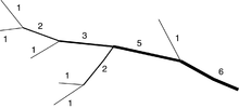
Flux ordinal number
The stream order ( FLOZ ) or waters atomic number is in the geomorphology and Hydrology a positive integer , the degree of branching in a water network indicates.
There are different approaches for the topological order of rivers or river sections according to their distance from the source or from the confluence (confluence of two rivers, see: mouth ) into the sea, and their hierarchical position in the water system.
The classic flow order
The classic river order assigns order one to the river ( stream ) flowing into the sea . Tributaries are each given an order that is one greater than that of the river into which they flow.
This flow order number emanating from the mouth characterizes the position in the river network. It is appropriate for general cartographic purposes, but poses problems because at each confluence it must be decided at which of the branches the river continues, or whether it has its (hydrological) source here as the confluence of two other rivers. In practice, one does not speak of a river, but of a strand, and the strand of order 1 is the one that is the larger, richer in water at each river junction, which largely reflects the traditional, very old naming of most rivers. The search of the geographers of the 19th century for the “true” source should also be understood in connection with this river order system. In the course of this, further criteria were discussed according to which the main strand could be defined. In addition to the flow path with the greatest length (source with maximum distance to the mouth) and the sizes of the respective sub-catchment areas to be compared, the focus was particularly on the greater constancy of direction at the point of confluence, also with regard to merely named main rivers that are subordinate in volume (such as Rhine / Aare or Elbe / Moldau ).
Flux ordinal number after emitter
According to Strahler , rivers of the first order are the outermost tributaries. If two rivers of the same order flow together, the confluence receives an ordinal number that is one higher; if two bodies of water with different FLOZ flow together, the higher one is transferred to the resulting body of water.
The radiator order is designed for the morphology of a flowing water area and is the basis for important hydrographic indicators of its structure, such as branching ratio, flux density and flow frequency. Its base is the watershed line of the catchment area. However, it is scale-dependent, depending on the flow measurement scale , other ordinal numbers arise. A general lower limit results from the definition of a body of water “river” across the mouth width, or the mapping based on a minimum extent. The system itself can also be used for smaller structures.
Shreve flow ordinal number
According to Shreve, the outermost tributaries also receive order one. At the confluence, however, the ordinal numbers add up.
The Shreve system is primarily used in hydrodynamics : It sums up the number of sources in the respective catchment area above a level / outflow, and roughly correlates with the outflow quantities and inputs. Like the radiator method, it depends on the accuracy of the sources recorded, but is less variable on the scale. It can also be made relatively scale-independent through suitable normalization and is then largely independent of a more precise knowledge of the upper and lower reaches of an area.
application
The classic application of the water regulations is general hydrological cartography. In the systematic recording of a water system, river management systems also provide important clues for the clear identification and assignment of water bodies.
The methods of Strahler and Shreve are particularly important for the modeling and morphometric analysis of water systems because they assign a number to a section of the river rather than a strand. In this way, the network can be separated at every level or outflow in the upper and lower water and these points can be classified. This is used as a basis for the representation of the water balance via storage models or time-related precipitation-runoff models and the like.
The latter two models are also used in GIS-based geosciences because they represent the “graphic thickness” of a river object. Fine structures of the tree can be hidden by choosing a lower threshold.
See also
- Water code - an overview
literature
- Arthur N. Strahler: Dynamic basis of geomorphology. In: Geological Society of America Bulletin. Volume 63, No. 9 (1952), ISSN 0016-7606 , pp. 923-938, doi : 10.1130 / 0016-7606 (1952) 63 [923: DBOG] 2.0.CO; 2 .
- Ronald R. Shreve: Statistical Law of Stream Numbers. In: Journal of Geology. Vol. 74, No. 1 (January 1966), ISSN 0022-1376 , pp. 17-37, JSTOR 30075174 .
- Bernd Pfützner: Rivertool. Extension for ArcView, user documentation. (No longer available online.) In: gis-tools.de. Bureau for Applied Hydrology, May 16, 2003, archived from the original on December 8, 2004 (with link to PDF preview).
- International glossary of hydrology (= IHP / OHP reports. Issue 12). 2nd Edition. Ed .: German National Committee for the International Hydrological Program (IHP) of UNESCO and the Operational Hydrological Program (OHP) of WMO. Koblenz 1998, ISSN 0177-9915 ( elise.bafg.de [PDF; 1.2 MB; German / English]).
- Thomas Koschitzki: GIS-based, automatic recording of natural river hierarchies and their mapping in databases, exemplified in the catchment area of the Salza. Dissertation, Martin Luther University Halle-Wittenberg, Halle (Saale) 2004, DNB 972731512 , urn : nbn: de: gbv: 3-000007179 .
Web links
- Water network: River order numbers for the digital water network 1: 25,000 in Switzerland. (No longer available online.) In: Hydrological basics and data - Information systems and methods - Water network - Flow order numbers. Federal Office for the Environment FOEN, archived from the original on November 14, 2014 ; Retrieved March 8, 2008 .
Individual evidence
- ↑ Koschitzki, 2.3, p. 12 ff.


