
Weidbach (Apfelstädt)
| Weidbach | ||
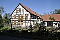
 Fish ladder at the Untermühle in Neudietendorf |
||
| Data | ||
| location | Germany, Thuringia | |
| River system | Elbe | |
| Drain over | Apfelstädt → Gera → Unstrut → Saale → Elbe → North Sea | |
| source | The confluence of the streams from the Saugraben and the Schnepfthal at Mühlberg 50 ° 51 ′ 57 ″ N , 10 ° 49 ′ 14 ″ E |
|
| Source height | 295 m above sea level NN | |
| muzzle | In Neudietendorf in the Apfelstädt left (northern) arm: 50 ° 54 ′ 30 ″ N , 10 ° 54 ′ 36 ″ E right (southern) arm: Coordinates: 50 ° 54 ′ 51 ″ N , 10 ° 55 ′ 5 ″ E 50 ° 54 ′ 51 ″ N , 10 ° 55 ′ 5 ″ E |
|
| Mouth height | 236 m above sea level NN | |
| Height difference | 59 m
|
|
| Right tributaries | Burgbach, Gräfenbrunnen water, Eymersborn spring water, Keltergraben, Schlammgraben ( "salt spring" ) | |
| Communities | Drei Gleichen ( Mühlberg ), Wachsenburg Office ( Sülzenbrücken ), Nesse-Apfelstädt ( Apfelstädt , Neudietendorf ) | |
The Weidbach is an approximately ten kilometer long right tributary of the Apfelstädt in Thuringia .
Geography and course
The brook has two source brooks: The water of the Saugraben , which rises on the edge of the military training area on the Ohrdrufer Platte in the southwest of Mühlberg . The stream then flows through a ravine-like depression in the direction of Mühlberg. Second, the stream of the Schnepfthals , which rises a little further south of the Saugraben headwaters. The two streams join in the Gänseweide near the village . Soon after entering the local area, the combined stream is strengthened by the water of the spring spring and is now called Weidbach. In the center it takes the water from the Burg Bach on which a horse well in Röhrensee rises and flows as trickle north to the foot of the lock Leite, a ridge between Miihlberg and wood Hausen . From there the Burgbach babbles in a northwesterly direction to Mühlberg. Here it crosses under Karl-Marx- and Burgstraße and takes in the Weidbach at the aqueduct . The aqueduct is an artificially created watercourse that used to be used to carry the Weidbach to the Steigmühle. Today the Weidbach water falls through an opening in the aqueduct into the Burgbach. In 1993 the aqueduct was renewed with monument preservation funds from the State of Thuringia. A few meters after the union with the Burgbach, the Weidbach served in the past to operate some of the Mühlberger mills.
Now it flows in a slight right curve in a north-easterly direction, past the Steigmühle , crosses under the Haarhäuser Straße, passes the Öl- und Graupen-Mühle , crosses under the Mühlenstraße and flows in a northerly direction towards the last mill in the Mühlberg area, the Feldmühle . Here at a height of 267.5 m from the left it absorbs the water of an unnamed stream, which has its headwaters on the grounds of Gut Ringhofen west of Mühlberg.
In the further course after about 1200 m, the water of the Eymersborn spring flows in from the right, which can be found on the north slope of the Schlossleite. Before it flows into the Weidbach, this water has crossed two peat cuttings ( flow-through bogs ) and has absorbed the water from the Graefountain . Now the brook leaves the Mühlberger area and the community Drei Gleichen and comes to the area of the district Apfelstädt of the community Nesse-Apfelstädt . Now the brook divides into a northern and southern course, encompassing the Apfelstädter Ried . The southern arm runs about 600 m along the municipal boundary until it reaches the Sülzenbrücken area at the southeast corner of the reed , takes up the Keltergraben and swings to the north.
300 m further, the two arms unite again at a height of 250 m and flow northwest towards the Sülzenbrücken location. Shortly before the development area, the mud ditch , which was previously reinforced by the salt spring , flows into the Weidbach. This touches the northern outskirts of Sülzenbrücken, crosses under the road to Apfelstädt, then the embankment of the Erfurt - Meiningen railway line, the A 4 and the 2147 road between Kornhochheim and the Apfelstädter industrial area.
At the Klemmsmühle the Weidbach meets the Neudietendorfer area. About 300 m further the brook branches out again: the northern arm flows into the Apfelstädt opposite the Gartenstraße immediately before the bridge to the sports field at a height of 239.9 m. The southern arm crosses under Kornhochheimer Strasse after 400 m, branches off again and flows in a north-westerly direction below the Kirchberg towards its mouth. One last benefit was in the past by supplying the lower mill with its water power. The last confluence of the two remaining arms of the stream flows into the Apfelstädt at a height of 236.3 m opposite Gotterstraße.
The mills
In the past, the Weidbach served to operate a number of mills:
- The Gölitzensmühle : The mill, first mentioned in 1528, is the first mill behind the spring. Until 1655 it was known as the Ringhofer Mühle . It was operated by spring water until 1969, and has been electrically powered since then until 1992. It got new mill wheels in 1992/93 and the mill technology is still very well preserved. In 1996 the vertical shaft was renewed.
- Former market mill: It was first mentioned in 1546 and operated as a grain mill until 1922. It has not been in operation since 1928, the grinding mill and water wheel have been removed, and the grinding mill and courtyard are under monument protection. The property was converted into a residential building in 1960.
- The oldest and largest mill in town is the Steigmühle . It was first mentioned in 1249 and operated by a total of 28 owners until 1970. The overshot mill wheel has a diameter of five meters. Gustav Freytag mentions the mill in his novel The Nest of the Wrens.
- The penultimate, formerly operated by the Weidbach mill on Mühlberger Terrain is the oil and pearl mill . The mill, first mentioned in 1528, fell victim to a major fire in 1728. After the technology was rebuilt and repaired with public funds, the mill is now working again and has housed the mill museum since June 9, 2003. The mill has a stamping and pressing plant from the 18th century and is the only functioning one of its kind in Thuringia.
- The Klemmsmühle on (New) Dietendorfer area was built in 1839–1841. It is the penultimate still visible mill of the Weidbach before the
- Untermühle in Neudietendorf.
- There was still a mountain mill in Dietendorf on the southern arm of the Weidbach before crossing under the Kornhochheimer Straße, of which, however, nothing can be seen today.
Pictures at the Weidbach

The Spring, the most important tributary of the Weidbach

Gölitzenmühle in Mühlberg

At the market mill in Mühlberg

"Aqueduct": The water of the Weidbach falls into the Burgbach stream bed

The "travertine staircase" in Mühlberg

At the Steigmühle in Mühlberg
At the oil and pearl barley mill in Mühlberg

The "salt source" at Sülzenbrücken

The pin mill near Neudietendorf

Fish ladder of a Weidbach arm near the Untermühle in Neudietendorf

Shortly before the confluence with the Apfelstädt


swell
- Topographic maps 1: 10000 No.
- 5131-NW, 1st edition 2009, ISBN 978-3-86140-950-2
- 5130-NO, 1st edition 2008, ISBN 978-3-86140-908-3
- 5031-SW, 1st edition 2007, ISBN 978-3-86140-825-3
- 5031-SO, 1st edition 2007, ISBN 978-3-86140-826-0
- Hiking map Drei Gleichen , 1: 15000, mr-kartographie, ISBN 978-3-00-030459-0
Web links
Remarks
- ↑ The brook is sometimes incorrectly written Waidbach on information boards and in hiking maps . The notation used here was taken from the topographic maps. There is, however, a Waidbach that flows into the Apfelstädt as a left tributary at Wandersleben.
- ↑ Neither in current nor in historical field and topographical maps is it proven that the stream above the Spring is / was called Weidbach.