
Roth (Apfelstädt)
|
Roth Red |
||
 Spring version of the Roth |
||
| Data | ||
| Water code | DE : 564266 | |
| location | Thuringia, Germany | |
| River system | Elbe | |
| Drain over | Apfelstädt → Gera → Unstrut → Saale → Elbe → North Sea | |
| River basin district | Elbe | |
| source | in Siebenben 50 ° 56 '19 " N , 10 ° 44' 3" E |
|
| Source height | approx. 284 m above sea level NN | |
| muzzle | Apfelstädt, east of Wandersleben Coordinates: 50 ° 54 '3 " N , 10 ° 51' 40" E 50 ° 54 '3 " N , 10 ° 51' 40" E |
|
| Mouth height | 258.3 m above sea level NN | |
| Height difference | approx. 25.7 m | |
| Bottom slope | approx. 2.1 ‰ | |
| length | approx. 12 km | |
| Left tributaries | Heulachsgraben , Seltengraben , Rettbachsgraben | |
| Right tributaries | Riedgraben | |
| Medium-sized cities | Gotha | |
| Communities | Tüttleben , three equals | |
| Navigable | No | |
The Roth , alternatively also Rot , is a tributary of the Apfelstädt in Thuringia . With its tributary Rettbach it forms the surface water body Roth . The water body ID is DETH_564266_0 + 12. In connection with the place Siebleben and Siebleber pond is Bach often cited.
Water classification
In the classification of flowing waters according to the Water Framework Directive , it is assigned to type VI, carbonate low mountain streams rich in fine material. It is considered an artificially modified body of water, the ecological condition and potential of which is assessed as poor. The chemical status in terms of the Water Framework Directive is good. Despite the deficits in the water structure, no measures are planned for the Roth surface water body in the Elbe River Basin Community's program of measures until 2015. The derogation according to Article 4 of the WFD was used for Roth.
According to § 3 of the Thuringian Water Act , the water has the status of a body of water II. Order and is therefore in the property and in the entertainment load of the communities that are traversed by the waters.
course
The water rises at a height of 284 m above sea level. NN in an allotment garden southwest of Mönchhof Castle . The spring is contained in a simple spring grotto. The source discharge is always the same. After just 300 m, the stream is straightened and accompanies the southern edge of Siebleben in a straight line . Shortly before the Mönchspark, it absorbs the water of a stream coming from the south. The Roth passes the two castle ponds 100 to 30 m away and flows north of the Siebleber sports field in a curve towards the northeast. At the herb garden the brook makes a right bend and flows north of the Siebleber pond in a south-east direction. East of the Siebleber pond, the Roth picks up the overflow from the pond and has a 20 m gradient behind it at this point.
Between Siebleben and Tüttleben , the Roth in Siebleber Ried absorbs water from drainage ditches. So z. B. the water of Schluftergrabens , the Ried trench from the direction Seebergen , the Heulachsgrabens ( Wächs source ) and the rare trench used, all of the drainage of the Ried. In Cobstädt , it unites with its most water-rich tributary, the Rettbach . After crossing under the embankment of the Thuringian main line at Wandersleben station , it flows a few hundred meters at a height of 258 m above sea level. NN in the apple city .
Siebleber Ried
From historical documents it can be seen that the Siebleber Ried with today's pond area represents the remainder of an Ice Age lake. The names of Seeberg and Seebergen are probably to be found here. To create fertile terrain, the area was drained via the Roth Bach. For this purpose, the Gotha city parliament at the end of the 17th century issued an order to the communities of Tüttleben and Cobstädt to open their trenches so that the water can flow out of the reed under threat of a fine of ten Reichstalers for non-compliance. The ducal order for this is dated September 23, 1697. After tough negotiations with the ducal government, the Siebleben community and the neighboring Mönchshof estate were granted the right to trustee the reed on June 22, 1709 . The first draft for the pond construction was only available on May 14, 1717, and in June the excavation began in place of the larger late glacial water surface, which today drains via a ditch to the Roth.
Origin of name
In the absence of documentary evidence, the origin of the name cannot be clearly established. A naming from the Old High German rod or the Middle High German red , based on the red color of the stream water, is possible.
There is a popular assumption that so many soldiers died in a battle between the Romans and Teutons on the Great Seeberg in the 3rd century AD that their blood colored the stream red, which would have led to the name being given.
Trivia
- The streets in Siebleben ( An der Rot ) and Wandersleben ( An der Roth ) are named after the water .
- The river basins of the Nesse and the Roth, which are only a few kilometers away, are separated by a ridge that was probably used as a path in prehistoric times . Today the B 7 runs along the section from Erfurt to Gotha.
Impressions
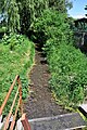
The red seen from the source
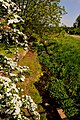
Tributary ditch to the Rot on the southern outskirts of Siebleben
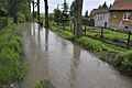
The red in Cobstädt during the flood on June 1st, 2013

Estuary: from the left the Rettbach, from the right the Rot, during the January floods 2011
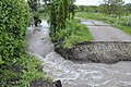
The road breakthrough for the Rot in Wanderslebener Bahnhofstrasse, during the flood on June 1, 2013. The passage under the bridge is too narrow for the water masses.


Web links
Individual evidence
- ↑ a b c d e official topographic maps, DTK25-V combination in color
- ↑ a b Map of river types with OWK boundaries ( memento of the original from June 7, 2013 in the Internet Archive ) Info: The archive link was inserted automatically and has not yet been checked. Please check the original and archive link according to the instructions and then remove this notice. of the Thuringian State Institute for Environment and Geology , accessed on February 5, 2012
- ↑ Thuringian state report on the management plans and programs of measures according to the EU Water Framework Directive. with the official management plans and programs of measures. (No longer available online.) Thuringian Ministry of Agriculture, Forests, Environment and Nature Conservation, December 2, 2009, archived from the original on February 3, 2016 ; Retrieved February 7, 2012 . Info: The archive link was inserted automatically and has not yet been checked. Please check the original and archive link according to the instructions and then remove this notice.
- ↑ WasserBLIcK : Natural, significantly modified and artificial water bodies in Germany
- ↑ EC-WFD action planning 2009-2015 in Thuringia - condition and target achievement of surface waters, published by TMLFUN, 2009
- ↑ EG-WFD action planning 2009-2015 in Thuringia - surface waters - material pollution by NH 4 -N, published by TMLFUN, 2009
- ↑ Management plan and program of measures of the FGG Elbe at www.flussgebiete.thueringen.de, accessed on February 6, 2012
- ↑ WasserBLIcK : Achievement of objectives and utilization of exceptions for surface water bodies in Germany
- ↑ Thuringian Water Act (ThürWG) in the version of the announcement of August 18, 2009, GVBl. Thuringia page 648
- ↑ Elfriede Ulbricht: The river basin of the Thuringian Saale . 1st edition. Max Niemeyer, Halle (Saale) 1957.
- ↑ Notes by Herbert May († 2017) in the Seebergen parish office
- ↑ An der Rot, on strassenkatalog.de
- ↑ An der Roth, on strassenkatalog.de
- ↑ Thuringian castles (their relationship to traffic routes) (PDF; 35 kB)
swell
- Topographic maps 1: 10,000 (TK 10) from the Thuringian Land Survey Office
- 5030-SW Gotha
- 5030-SO Gotha-Siebleben
- 5031-SW Neudietendorf