
Kleinrettbach
|
Kleinrettbach
Rural community of Nesse-Apfelstädt
Coordinates: 50 ° 56 ′ 3 ″ N , 10 ° 53 ′ 9 ″ E
|
|
|---|---|
| Height : | 291 (290-302) m |
| Residents : | 278 (December 1, 2009) |
| Incorporation : | March 14, 1974 |
| Incorporated into: | Gamstädt |
| Postal code : | 99192 |
| Area code : | 036208 |
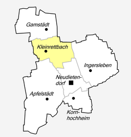  Location of Kleinrettbach in Nesse-Apfelstädt
|
|
Kleinrettbach is a district of the rural community of Nesse-Apfelstädt in the Thuringian district of Gotha . Before the municipality of Nesse-Apfelstädt was founded on December 1, 2009, the village was part of the municipality of Gamstädt , into which it was incorporated on March 14, 1974.
location
The place is on the southern edge of the Thuringian Basin , about 2 km south of Gamstädt. The busy state road L 1044 runs through it between the Gamstädt junction of federal road 7 and the confluence of the road about 2 km further south into the district road K3, which connects the towns of Neudietendorf and Großrettbach . The local area lies at a height of 288 m (at the entrance of the Rettbach on the Großrettbach area) to 302 m (on the Grabslebener Weg near the historic birch). The town center is 290 m above sea level.
A few hundred meters east of the village, the eponymous Rettbach rises in the Siebgen spring .
The highest point of the village boundary at 308 m above sea level. NN is northwest of the locality, a few 100 m north of the historic birch . The Elbe-Weser watershed runs here : the Nesse, flowing to the north, flows into the Hörsel near Gamstädt , which in turn drains into the North Sea via the Werra and Weser; the southern apple city is a tributary of the Saale, which flows into the Elbe.
history
Kleinrettbach was first mentioned between 775 and 802 in a document as a gift to the Hersfeld monastery . However, it has not been proven whether the name Rutibah mentioned in the document actually stands for Kleinbach or Großrettbach or for both places. Other traditional spellings are Rudibach, Retbich or Reedewich . A document in the State Archives Saxony-Anhalt , Magdeburg , contains a text passage in which there is talk of a village called Rythebeche . This document from July 25, 1284 is the oldest evidence of the existence of the place so far. It is a sales confirmation from Landgrave Albert of Thuringia to the St. Martini Monastery in Erfurt. The place thus belonged to the area of the city of Erfurt in the following period .
Around 1500 the place had the name Wenigen Rettbach .
Since the administrative reform of 1706 he belonged to the Alach office . In 1802 the place came with the Erfurt area to Prussia and between 1807 and 1813 to the French Principality of Erfurt .
With the Congress of Vienna the place came back to Prussia in 1815 and in 1816 it was affiliated to the Erfurt district in the Prussian province of Saxony . Kleinrettbach was the only one of the later districts of the municipality of Nesse-Apfelstädt to belong to Prussia (Province of Saxony); only after the end of the Second World War did the place become part of Thuringia.
On March 14, 1974, Kleinrettbach was incorporated into the municipality of Gamstädt and on December 1, 2009, with the re-establishment of the municipality of Nesse-Apfelstädt, it became a district. As part of a referendum on September 14, 2014, the majority of the rural community decided to give Kleinrettbach the status of a locality, which means that it is now possible to appoint an independent local mayor and local council.
coat of arms
In the formerly independent communities of Kleinrettbach and Gamstädt, their own seals were kept until 1952. The seal of the community of Kleinrettbach showed the perspective representation of the Siebgenquelle, which served as a water supply for decades; the name Rettbach was derived from Rieth- or Rutibach and it arises from the Siebgen spring.
economy
The most important branch of business in the place is agriculture . There is an agricultural operation here as a branch of Agrar GmbH from Gamstädt, a successor to the former LPG . In the farm shop at Christmas time geese , ducks and drakes from our own breeding are sold, which can be seen in the surrounding meadows in late summer and autumn.
History of the local agriculture
Kleinrettbach's agriculture has a centuries-old tradition. Since only a few residents were employed outside the town and there were no large craft or industrial businesses in the town, agriculture was the basis of food and the main source of income for the residents. Mainly field forage cultivation was practiced in individual family farms . Meat , milk , butter , eggs , flour , vegetables and other plant products as well as fodder were produced for their own needs . The proceeds from the sale of products not produced for their own use were used to improve the quality of life and to purchase fertilizer , seeds , agricultural equipment and to buy breeding and livestock . Apart from sugar beet and flax, no products were grown for further industrial processing .
That changed after the end of the Second World War , when the Soviet occupying power introduced compulsory deliveries, which induced the farms to grow certain special crops ( tobacco , poppy seeds , flax ). This applied both to field cultivation and to livestock farming. The farms were staggered according to the size of the farm and the presumed soil quality . Since the Kleinrettbach farms had good soil quality, they had to meet a high delivery target. The 46 farms were staggered into classes 1–5 ha (12), 6–10 ha (16), 11–15 ha (13), 16–20 ha (4) and over 20 ha (1). The largest farm cultivated an area of almost 30 hectares. Problems arose on the farms due to the lack of workers, because many people were war victims and because unfavorable weather conditions were not taken into account, but led to shortage of harvests. More and more people went to work in Erfurt or Gotha because they could earn more there and also had various discounts.
In order to achieve a reasonably acceptable standard of living after the war, a machine and tractor count was made in 1946. It resulted u. a. that the farms had a total of eight farm tractors, six of which came from the years 1925–1928 and were still equipped with iron tires. In addition, there was a grinding plant , a seed cleaning and dressing plant and a mobile threshing machine for cross-company use . Then there were various other devices that were necessary for a farm. Equipment was also counted that is no longer relevant today: butter churns and crank-operated milk centrifuges .
The first agricultural production cooperative (LPG) was founded on February 14, 1958. 23 members brought a total of almost 10 hectares into the cooperative. In the next two years, more farmers joined the LPG. Another LPG was founded on March 30, 1960, but it joined the first LPG with its three farmers after just 24 hours. On January 1, 1974, the LPGs from Kleinrettbach, Gamstädt and Frienstedt merged to form a Cooperative Plant Production Department (KAP). Many other measures should lead to bringing the production quality of the companies to the same high level in order to improve the results. Buildings were built to enable animal welfare , silos and cesspools were built, larger sheds, workshop buildings, cowsheds, etc.
At the end of the 1960s and the beginning of the 1970s, the structures of the places at that time and thus also those of the production units were changed. As a result, the construction brigade Kleinrettbach was integrated into the LPG Ermstedt . The new tasks of the construction brigade included the construction of new production facilities and the creation of vacation options such as the vacation centers in Plothen , Schleusingen and Farnroda from 1976 to 1980.
Attractions
Village church

The center of the place is the church of St. Severi .
Stone crosses


Two stone crosses testify to the eventful history of the village: one is to the east of the village ("Erfurt Cross") and one to the west ("Grabslebener Kreuz"). According to a local legend, their origin goes back to an incident during the Thirty Years' War . One day two hostile armies are said to have faced each other on this side and on the other side of the village. After they had prepared for the attack in the night, in the morning thick fog lay over the camps and the landscape, so that the armies did not meet in the village, but missed each other. In gratitude for the sparing of the village from the suffering of war and as a request for the future, the villagers erected a stone cross at each of the camps' sites. The crosses are also called "Swedish crosses" and are made of Seeberg sandstone. However, their diversity suggests that they are not from the same period. However, both are very old, probably from the 15th century, because they were mentioned in the Kleinrettbacher plot descriptions as early as 1691: Farmland was mentioned with the name "on Erffurter strassen ... at the Erffurter Creutz". As early as 1683, both crosses were drawn on the oldest Kleinrettbach floor plan. In the 19th century the route to Grabsleben and Erfurt was changed and with it the location of the crosses. Since then, the Grabsleben cross stood in the middle of a field and was not visible when the grain was high. As a result, there was a risk of the cross being injured by agricultural machines, but also damage to these machines. Therefore, in 2008 it was moved to the new Grabslebener Weg and furnished with a seating area. The Grabsleben cross has a (above-ground) height of 125 cm, is 88 cm wide and, with a thickness of 33–38 cm, appears extremely powerful. The Latin basic form shows bars crossed at right angles. On the underside of the arm and on the side of the shaft, the typical traces of hilt can be seen. In 1866 a treasure was suspected under the cross, but the search was in vain. The Erfurt cross is approx. 15 cm higher than its western counterpart , but with its lower beam height and thickness and its differently shaped arms it appears more elegant and delicate. The head, arms and shaft taper towards the middle, the edges are rounded. The cross stands across the path. A bench nearby invites you to linger. This cross is the older of the two. None of the crosses have any inscriptions or drawings. Both crosses are on the old trade route between Erfurt and southern German areas. They were shown on the map of the escort roads from 1633 as "Landt Stras Von Erfurt Vber den Waldt (= Thuringian Forest ) Vf Schmalkalden Vndt Franckfurt". The map was published by Luise Gerbing in 1894 . The western cross is also still on a Way of St. James .
In the vicinity of the Grabsleber Kreuz there is a historical birch tree (that's the name on a signpost), which shows its age, but not its historical significance. Corresponding information is also not available on information boards. On an old map the place is marked with Die Dornenhecke , of which, however, nothing can be seen today.
Rettbach and Siebgen source

The Siebgen spring is located northeast of the village. The Rettbach rises here .
Individual evidence
- ↑ Kleinrettbach. Story in words and pictures. Publisher: Association for the Preservation of the Village Church “St. Severi ”in Kleinrettbach eV, 2009
- ↑ Information board on the stone crosses