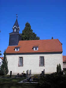
Rohda (Haarberg)
|
Rohda (Haarberg)
State capital Erfurt
Coordinates: 50 ° 56 ′ 44 ″ N , 11 ° 7 ′ 40 ″ E
|
|
|---|---|
| Height : | 276–294 m above sea level NN |
| Area : | 3.6 km² |
| Residents : | 242 (December 31, 2016) |
| Population density : | 67 inhabitants / km² |
| Incorporation : | March 14, 1974 |
| Incorporated into: | Windischholzhausen |
| Postal code : | 99099 |
| Area code : | 0361 |
|
Location of Rohda (Haarberg) in Erfurt
|
|

Rohda (Haarberg) is a district of the Thuringian capital Erfurt . To distinguish it from Rhoda (Steiger) , which also belongs to Erfurt , it has the addition of the name Haarberg , after the mountain at whose foot it lies.
geography
Rohda is located on the upper reaches of the Linderbach about eight kilometers south-east of Erfurt. The district is hilly and consists of three forests: the Wechselholz east of Rohda, the Büßlebener Holz southeast of Rohda and the Klosterholz south of Rohda. The Haarberg colony , a settlement of weekend houses above the village on the state road from Erfurt to Kranichfeld, also belongs to Rohda . Neighboring villages are Niedernissa in the west, Obernissa in the east and Büßleben in the north.
history
Rohda was first mentioned in a document in 1249. It belonged to the county of Vieselbach , which the Counts of Gleichen sold to the city of Erfurt in 1343 . The village remained tied to Erfurt until the Congress of Vienna in 1815 and belonged to Kurmainz . At the Congress of Vienna, the village was assigned to the Grand Duchy of Saxony-Weimar-Eisenach , to which it belonged until 1920. After that it became part of the newly founded state of Thuringia and the district of Weimar . In 1952 it became part of the Erfurt-Land district .
On March 14, 1974, Rohda was incorporated into what was then the municipality of Windischholzhausen . On July 1, 1989, the village was reclassified to the community of Niedernissa and on July 1, 1994 together with her to the city of Erfurt.
Population development
- 1843: 99
- 1910: 125
- 1939: 158
- 1995: 244
- 2000: 291
- 2005: 305
- 2010: 299
- 2015: 254
Economy and Transport
Rohda is almost entirely a residential area. The next industrial areas are in Erfurt-Südost and on federal highway 7 in Linderbach .
Roads connect Rohda with Niedernissa and Obernissa.
Individual evidence
- ↑ Municipalities 1994 and their changes since January 1, 1948 in the new federal states , Metzler-Poeschel publishing house, Stuttgart, 1995, ISBN 3-8246-0321-7 , publisher: Federal Statistical Office
- ^ Johann Friedrich Kratzsch : Lexicon of all localities of the German federal states . Naumburg, 1843.
- ↑ gemeindeververzeichnis.de
- ↑ Michael Rademacher: German administrative history from the unification of the empire in 1871 to the reunification in 1990. (Online material for the dissertation, Osnabrück 2006).
- ↑ Population of the city districts

