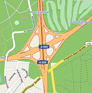
Cologne-Süd motorway junction
| Cologne-Süd motorway junction | |
|---|---|
|
|
|
| map | |
| location | |
| Country: | Germany |
| State : | North Rhine-Westphalia |
| Coordinates: | 50 ° 53 '8 " N , 6 ° 58' 6" E |
| Height: | 40 m above sea level NN |
| Basic data | |
| Design type: | Adapted shamrock |
| Bridges: | 2 (motorway) / 2 (other) |
| Construction year: | 1941 |
| The A4 in the direction of Olpe before the Köln-Süd junction | |
The Köln-Süd motorway junction (abbreviation: AK Köln-Süd ; short form: Kreuz Köln-Süd ) is a motorway junction in North Rhine-Westphalia that is located in the Rhine-Ruhr metropolitan region . This is where the federal highway 4 ( Aachen - Eisenach - Görlitz ) and the federal highway 555 ( Cologne - Bonn ) cross. The Köln-Süd junction is also part of the Cologne motorway ring .
geography
The motorway junction is located in the area of the city of Cologne. The closest districts are Hahnwald , Immendorf , Rodenkirchen , Marienburg , Rondorf and Raderthal . It is located about 20 km north of Bonn and about 6 km south of Cologne city center.
The Köln-Süd motorway junction is number 12 on the A 4 and number 2 on the A 555.
State of development
The A4 has been expanded to six lanes in this area. The A 555 can be driven on 4 lanes in the cross itself; but it is expanded to six lanes in front of the cross and behind the cross (there through to Bonn ). All transitions are single-lane.
The Cologne-Süd motorway junction is also to be rebuilt larger in the future (details are not yet known). As a first measure, an additional (makeshift) bridge structure was built to unbundle the traffic flows (completed in April 2017) to avoid the backlogs on the A4 that can be observed every day (due to the traffic turning off the A4 from the east towards the A 555 to the south towards Bonn) and to avoid or at least reduce the A 555 (due to the traffic turning off the A 555 from the south, direction A 4 to the west, direction Aachen).
particularities
The A 555 has existed in this area since 1932, making it the oldest four-lane, intersection-free motor vehicle in Germany.
The two carriageways of the A 555 are separated here and led over the A 4 via various bridge structures.
Traffic volume
The cross is one of the busiest road junctions in North Rhine-Westphalia.
| From | To | Average daily traffic volume |
|---|---|---|
| AS Containerbahnhof Köln-Eifeltor (A 4) | AK Cologne-South | 125,400 (heavy load share: 14.8%) |
| AK Cologne-South | AS Köln-Poll (A 4) | 134,200 (heavy load share: 13.9%) |
| AS Köln-Bayenthal (A 555) | AK Cologne-South | 57,200 (heavy load share: 4.4%) |
| AK Cologne-South | AS Köln-Rodenkirchen (A 555) | 95,900 (heavy load share: 6.6%) |
Individual evidence
- ^ AK Cologne-South. Motorway junctions and triangles in Germany, 2011, accessed on November 19, 2012 .
- ↑ Information on the A4 / A555 - new bridge construction at the Cologne-Süd motorway junction of the State Office for Road Construction NRW (accessed: October 11, 2016)
- ↑ Manual traffic census BAB 2015. (PDF) BASt Statistics, 2015, accessed on June 21, 2017 . (PDF file)
- ↑ Note: Since in the following section between the Cologne-Poll junction and the Cologne-Gremberg motorway junction "only" an average of 125,000 vehicles (heavy load share: 15.6%) was measured, it seems that between the Cologne-Süd junction and the Cologne-Gremberg junction Poll to give a noticeably strong regional traffic, which presumably mainly uses the Rhine bridge between Cologne-Rodenkirchen .

