
Marienburg (Cologne)
|
district 202 of Cologne |
|
|---|---|
 |
|
| Coordinates | 50 ° 54 '1 " N , 6 ° 58' 12" E |
| surface | 3.05 km² |
| Residents | 7008 (December 31, 2017) |
| Population density | 2298 inhabitants / km² |
| Incorporation | Apr 1, 1888 |
| Post Code | 50968 |
| prefix | 0221 |
| Borough | Rodenkirchen (2) |
| Transport links | |
| Highway |
|
| Federal road |
|
| Light rail lines | 16 17th |
| Bus routes | 106 130 132 134 |
| Source: 2017 residents . (PDF) Cologne district information | |
The Marienburg district is located in the south of the city of Cologne . Politically he belongs to the Rodenkirchen district . Marienburg is one of the preferred and high-priced districts of Cologne when it comes to the real estate market.
location
Marienburg borders the Rhine in the east , Rodenkirchen in the south with the Bundesautobahn 4 , the Raderthal district in the west and Raderberg and Bayenthal in the north . Poll is directly opposite on the right bank of the Rhine .
Territory structure
The Marienburg district, which is actually popularly only known as a noble villa district, is cartographically characterized by a significantly larger area and thus also by a more heterogeneous regional structure than superficially assumed. The cartographic area of the Marienburg district is therefore effectively divided into two separate quarters by the Bonner Straße , which acts as a dividing line, but this is only more noticeable when you take a closer look at the area map.
Marienburg does not only consist of the noble villa district that gives the district its name, which is roughly described between Bonner Strasse and the banks of the Rhine and comprises the significantly larger part, namely around 80% of the entire district area. In addition, other larger areas to the left of Bonner Strasse in the direction of the city center are politically part of the Marienburg district, although they only make up around 20% of the Marienburg area. The latter area, which is almost triangular in total, only begins at today's Arnoldshöhe bus stop on the left side of Bonner Strasse in the direction of the city center (a new tram stop with the same name is currently planned here for the near future) and not at the southern distribution circle, where the rest of the Marienburger The area to the right of Bonner Strasse with the Protestant garrison church begins much earlier. The Marienburger tennis club with the name TC Arnoldshöhe, which is diagonally opposite this church, is not located on the actual Marienburger city plot, but rather belongs to the neighboring district of Cologne-Raderthal .
The Marienburger part of the villa colony to the right of Bonner Straße is largely characterized by a formative historical villa architecture and thus primarily by very noble residential developments. Company buildings that are recognizable from the outside can only be found here in very specific and isolated cases, such as B. the kiosk at Südpark or the pharmacy on Pferdmengesstraße. In the area facing Bonner Strasse, there are also more simply designed residential buildings. Likewise, within the residential area, there are also - albeit only relatively smaller and also higher quality - residential complexes with rental and owner-occupied apartments. In addition to the classic villa architecture, there are also some new modern residential buildings to be found there. In some villas there are also fully or only partially representative offices of companies as well as administrative centers of various institutions, which are hardly visible to the outside as non-residential use due to the accommodation in actual residential buildings or only recognizable as such at second glance are.
The significantly smaller Marienburg urban area to the left of Bonner Strasse in the direction of the city center extends all the way to the Raderberggürtel ring road and then runs along the Raderberggürtels to the current location of the national public radio station Deutschlandfunk . From there, the district boundary runs almost in a straight line back to the Arnoldshöhe bus stop mentioned above , which is then diagonally opposite the confluence with Marienburger Lindenallee in the villa district directly opposite. The area is apparently seen by the city of Cologne as a whole as a separate city quarter or city quarter (in Cologne dialect this is called Veedel ) under the independent name Arnoldshöhe within the Marienburg district, although the name of the bus stop with the name Arnoldshöhe and the name of the TC Arnoldshöhe tennis clubs in the immediate vicinity of this stop , as well as a major construction project just a few meters further into town from the name-bearing bus stop, also with the name Arnoldshöhe , could indicate that at least in the vernacular there is only a medium-sized area around the one here Much quoted bus stop Arnoldshöhe could be meant.
Large parts of the area outlined by the city of Cologne as Arnoldshöhe are currently undergoing major structural structural change. Until around the end of the 2000s, the area was largely crossed by commercial and administrative buildings and therefore only occasionally or in a rather subordinate manner, especially multi-storey residential buildings. Since then, however, the commercial buildings have been gradually disappearing here, mostly in favor of higher-quality and therefore more expensive living space or even more noble large residential complexes. In contrast to the diverse single-family houses in the villa district, the residential development here is characterized exclusively by larger stocks of rental and owner-occupied apartments. With the large residential project Reiterstaffel , z. For example, the former, very spacious area of the Cologne police rider's squadron has been converted into a large residential area for around 1,000 residents including a supermarket, elementary school and daycare center, and into high-quality living space with an independent regional identity. A similar large-scale construction project is currently planned for the former Deutsche Welle area, but this can only begin after the long-planned demolition of the striking Deutsche Welle high-rise.
In the lower part of Bonner Strasse, very close to the Raderberg belt, there are a number of office buildings as well as smaller shops and a small local supply supermarket, although the majority of the small shops have been vacant for some time, as has been noticed elsewhere in Germany . The industrial plants of the traditional company Leybold (manufacture of vacuum pumps), which are also located in the area, with the glass administration building on Bonner Strasse, which has been striking for some time, has apparently been spared from the massive restructuring in the area, so that the striking commercial buildings, and especially that only recently The administration building, architecturally significantly enhanced by a glass façade, will probably continue to shape the cityscape there in the future. The strong connection of the company to the Marienburg villa quarter opposite is clearly visible and unmistakably embodied by the street name Leyboldtstraße there in the immediate vicinity of the company location .
Another major structural change project in the Marienburg district is the redesign of Bonner Strasse, which is planned for the near future, into an attractive and significantly wider avenue. Associated with this is the extension of the Stadtbahn to the southern distribution circle, which is currently also intended to include a larger commuter parking garage under the working title of North-South Stadtbahn , as well as an option to switch from the Stadtbahn to the bus near the current Arnoldshöhe bus stop . Correspondingly, the currently planned relocation of the Cologne wholesale market to the nearby Cologne-Raderberg district is also forecast to reduce traffic congestion on the newly designed Bonner Strasse in the Marienburg district. At the same time, the planned connection of the district with the new tram is likely to drive the ongoing conversion of commercial space into living space on Bonner Straße itself, but also in the Arnoldshöhe area to the left .
history

South of the former city of Colonia Claudia Ara Agrippinensium , the Alteburg naval fort was built around 20 AD at the height of today's street “Im Römerkastell”. On an area of around six to seven hectares, it should have provided space for more than a thousand people. It received a stone fence at the latest in AD 100 and was destroyed by the Franks in 276 . A tombstone of Lucius Valerius Verecundus found here, whose unit served in Germania from 69 AD, probably died here shortly after 70 AD.
According to the "Cöllner Schweid " by Abraham Hogenberg , development did not begin in the area until after 1609. In 1782, the Cologne councilor Johann Wilhelm Joseph Huybens laid out a 20-acre "English park" on the old naval fort. On April 6, 1813, Peter Joseph Prengrulier sold the "Gut Alte Burg" (An der Alteburger Mühle 6) to Ludwig Böcking and defined the 184 Prussian acre area as a windmill - the tower torso of which is still preserved today - residential house, farm building and arable land . Böcking built the first industrial operation here, a lime distillery, but sold the area to manufacturer Paul Josef Hagen in January 1845. This had already acquired the Marienburg manor in 1843 ; The district is named after him. At the end of the 18th century, the Alteburger Mühle (An der Alteburger Mühle 6), which has been preserved to this day, was built on the site of the fort . The only industrial building was the "Rheinische Aktienbrauerei Alteburg" founded in 1873. In 1878/79 the new town hall of the municipality of Rondorf was built on Marienburger Straße (formerly Rathausstraße ), but it lost its function when it was incorporated into Cologne in 1888 and was demolished in 1929. In September 1867 there was a contract with John Moore for the construction of the Alteburg waterworks.


In Marienburg, street names were clearly given with romanticizing intentions, especially in the villa streets Lindenallee, Parkstrasse and Unter den Ulmen. These and other streets developed into villa colonies for wealthy Cologne industrialists and bankers during the founding period . This is due in particular to the initiative of the Cologne businessman Ernst Leybold , who, in addition to his work as a freight forwarder, also acted as a real estate speculator. He had bought the Marienburg estate, built in 1845, together with the manor house and an additional 60 hectares of fields, together with Adolph Davignon (Leipzig), councilor of commerce, from the Sal. Oppenheim bank in February 1868 . Leybold took over Davignon's shares in 1871. While Leybold moved into the manor himself in 1874, he parceled out the free land and sold it to wealthy interested parties. However, his speculative real estate business increasingly strained his economic situation, so that in 1880 he leased the Marienburg estate and had to move into a rented apartment. Together with Rudolf Schulz, he founded the real estate company Leybold & Cie in 1880. He also founded the “Actiengesellschaft Marienburg-Cöln”, which dealt with the “Marienburg” project. At the end of 1891 he transferred his Marienburg property to Leybold & Cie. emerged "Kölnische Immobilien-Gesellschaft AG".
The expansion of the villa suburb accelerated when it was incorporated into Cologne on April 1, 1888, as a result of which the road construction passed into the hands of the city and in 1896 Camillo Sitte suggested a uniform development plan with transport links, which was implemented by city architect Josef Stübben . The development of Marienburg began around 1895 and was largely completed around 1925. This means that over a period of around 30 years in a large number of palatial buildings, the development of architecture from the outgoing historicism to Art Nouveau , Expressionism and modernism can be followed. The architects include numerous renowned personalities, such as Joseph Maria Olbrich , Paul Pott , Paul Bonatz , Bruno Paul , Otto March and Hanns Koerfer . Many Cologne architects such as Dominikus Böhm , Franz Brantzky , Theodor Merrill , Carl Moritz , Wilhelm Riphahn and Schreiterer & Below also built in Marienburg . Pott and Merrill were the most important architects of Marienburg. This concentrated arrangement of outstanding villa architecture resulted in a residential development which, in this compactness, can only be found in the Berlin and Munich suburbs in Germany. The villa area in Marienburg is still today a residential area characterized by magnificent buildings from the turn of the century with extensive gardens, avenues and parks. The Marienburg villas have always been seen as a total work of art, because they were embedded in a large garden, wall paintings inside and often with furniture that was individually designed for the house.
The development with representative villas for the "Cologne nobility" - wealthy families of the upper class - took place in particular in Lindenallee and the adjacent Parkstrasse and has earned Marienburg the nickname "villa suburb" as one of the most exclusive and important villa districts in Germany. Only Berlin-Grunewald or Grünwald are comparable . The district is one of the best preserved areas of the city of Cologne, because it was largely spared from destruction during the war - unlike the other city areas. The settlement was carried out in the open construction method with villas and palatial, stately residences along curved and straight streets. Numerous villas from this period are still preserved today.

At the end of the Bayenthal Belt on the Rhine side, the 27-meter-high Bismarck Tower was built in 1902 based on a design by the Berlin architect Arnold Hartmann . The construction costs were mainly financed by Heinrich Stollwerck , who had a villa built in the immediate vicinity on the Bayenthalgürtel 2 property , which he called "Bismarckburg". Rheinuferstraße and Oberländer Ufer were laid out as a wide promenade between 1895 and 1897, followed by the southern park between 1898 and 1901 .
After the nearby Bonn became the seat of government of the Federal Republic of Germany in 1949, Marienburg was initially the location of some residences of foreign diplomatic missions and embassies , before it was gradually replaced by Bad Godesberg in its capacity as "Bonn's diplomatic quarter" . For senior British members of the Allied High Commission , houses with a living space of up to 400 m² each were built in Marienburg. The Iranian embassy was located at Parkstrasse 5 (later the so-called “Iranhaus”) and moved to Bonn in 1973; Switzerland only moved its embassy from Bayenthalgürtel 15 to Bonn in 1977 . The residences of India ( Rondorfer Strasse 9 ; demolished in 1977), Canada ( Lindenallee 70 ) and Brazil ( Parkstrasse 20 ) also belonged to the more important embassy locations . Some of the large villas now serve as offices.
The British military broadcaster BFBS , which resided there in the Villa Tietz until October 1990, had been in Lindenallee since February 1954 . Even the Germany radio had its former site between January 1962 and February 1979 in Lindenallee 7 - in a converted as radio house villa, the Polish Embassy in the follow-on seat and from 1999/2000 to 2013, Consulate General of the Republic of Poland was home. Some federal institutions and organizations had their headquarters in Marienburg - also because of its proximity to the Bonn government seat. Among them was the German Association of Cities in Lindenallee, which was initially in several rented villas from 1948 and later in one from 1971 to 1973 under demolition new office building erected in three existing buildings (architects: Joachim and Margot Schürmann) resided; Canceled in 2010.
Demographic statistics
Structure of the population of Cologne-Marienburg:
- Share of under 18s: 16.0% (2014)
- Proportion of over 64-year-olds: 20.3% (2014)
- Proportion of foreigners: 16.0% (2015)
- Unemployment rate: 6.2% (2014)
Churches


The Protestant Reformation Church (Goethestrasse) was built between 1903 and 1905 according to the plans of the Berlin architect Otto March . Destroyed in 1943, it was significantly redesigned during the reconstruction. Also in Goethestrasse is the Catholic parish church of St. Maria Königin , which was built from 1952 to 1954 according to plans by Dominikus Böhm . The church rises above a square floor plan. It opens up to the surrounding park along the entire length of the south wall. The tower was built in 1960 based on a design by Gottfried Böhm .
The Evangelical Garrison Church of All Saints of the Evangelical Military Parish Office Cologne I is located in Lindenallee at the corner of Bonner Straße. The Anglican community uses the church as an All Saints Chapel .
Worth seeing
- The plant of a listed putti fountain is the work of an unknown artist from 1910. The fountain is at the end of Parkstrasse.
- The listed sculpture of a panther by Fritz Behn, created around 1920, is in the Südpark .
- The Cologne Fortress Museum is located in the intermediate plant VIII b between the military ring and the A4 motorway.
- List of architectural monuments in the Marienburg district of Cologne
- In the Sinzigerstraße you will find the Fritz-Encke -Volkspark which was named after the Cologne gardening director in the 1930s.
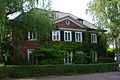
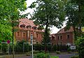
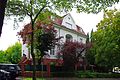
Examples of villa development in Marienburg

Sacrificial Angel House, Bayenthal Belt 4

Schröder House, Bayenthal Belt 15
Goethestrasse 8

Kastanienallee 20
Lindenallee 7
Palestine House, Under the Elms 96


Known residents
- Gottfried Böhm (* 1920), architect and Pritzker Prize winner
- Josef Feinhals (1867–1947), cigar manufacturer and art patron
- Hans Gerling (1915–1991), entrepreneur
- Elke Heidenreich (* 1943), television presenter
- Friedrich Carl Janssen (* 1944), former personally liable partner of Sal. Oppenheim jr. & Cie.
- Hans Katzer (1919–1996), Federal Minister for Labor and Social Affairs
- Ingolf Lück (* 1958), presenter and comedian
- Alfred Freiherr von Oppenheim (1934–2005), banker
- Robert Pferdmenges (1880–1962), banker, former partner of Sal. Oppenheim jr. & Cie.
- Marc, Oliver and Alexander Samwer (* 1970, * 1973 and * 1975), entrepreneurs
- Harald Schmidt (* 1957), German cabaret artist, actor and presenter
- Dieter Schütte (1923–2013), German publisher
- Franz Stollwerck (1815–1876), entrepreneur
- Heinrich Stollwerck (1843–1915), entrepreneur
- Ludwig Stollwerck (1857–1922), entrepreneur
- Leonhard Tietz (1849–1914), entrepreneur
- Alfred Leonhard Tietz (1883–1941), entrepreneur
- Otto Wolff von Amerongen (1918–2007), entrepreneur
- Gerhard Zeiler (* 1955), Executive Board member of the RTL Group
- Klaus Zumwinkel (* 1943), former CEO of Deutsche Post AG
See also
literature
- Wolfram Hagspiel : Cologne. Marienburg. (= Stadtspuren, Monmäler in Köln , Volumes 8.I and 8.II.) JP Bachem Verlag, Cologne 1995, ISBN 3-7616-1147-1 .
- Wolfram Hagspiel: Marienburg. A Cologne villa district and its architectural development. JP Bachem Verlag, Cologne 2007, ISBN 978-3-7616-2012-0 .
- Frank Thomas, Sofie Trümper: Bayenthal - Marienburg. 150 years of living and working on the Rhine. Festschrift published by the Cologne-Bayenthal-Marienburg Citizens' Association. Cologne 1985
- Frank Thomas, Sofie Trümper: Bayenthal - Marienburg. Stories from the history of Bayenthal and Marienburg. Catalog for the exhibition June 7 - July 15, 1988. Published by the Cologne-Bayenthal-Marienburg citizens' association. Cologne 1988
- Tradition and progress. 75 years of the Reformation Church in Cologne-Bayenthal / Marienburg . Festschrift published by Presbytery of the Evang. Local community. Cologne 1980
Web links
Individual evidence
- ^ District Arnoldshöhe (Cologne) in the official koeln.de city map
- ↑ https://www.corpussireo.com/~/media/Files/corpussireo_com/Contentpage%20Downloads/Makler/Koeln/mappe_arnoldshoehe.ashx
- ↑ https://www.sparkasse-koelnbonn.de/pdf/content/PK_BauenWohnen/Cityreports/cityreport2011.pdf
- ↑ Kölnischer Geschichtsverein, Jahrbuch Volume 23 , 1941, p. 7
- ^ Hiltrud Kier / Wolfgang Hagspiel / Dorothea Heiermann / Ulrich Krings: Stadtspuren: Monuments in Cologne. Volume 8, 1996, p. 59
- ^ Marion Werner: From Adolf-Hitler-Platz to Ebertplatz. 2008, p. 275
- ^ City of Bonn, City Archives (ed.); Helmut Vogt : "The Minister lives in a company car on platform 4": The beginnings of the federal government in Bonn 1949/50 , Bonn 1999, ISBN 3-922832-21-0 , p. 224.
- ^ Helmut Vogt: Guardians of the Bonn Republic: The Allied High Commissioners 1949–1955. Verlag Ferdinand Schöningh, Paderborn 2004, ISBN 3-506-70139-8 , p. 99.
- ^ Wolfram Hagspiel : Cologne. Marienburg. Buildings and architects of a villa suburb. In city lanes, monuments in Cologne. Volume 8, JP Bachem Verlag , Cologne 1996, ISBN 3-7616-1147-1 , Volume 2, pp. 680-684
- ^ Wolfram Hagspiel: Cologne. Marienburg. Buildings and architects of a villa suburb. In Stadtspuren, Denkmäler in Köln , Volume 8, JP Bachem Verlag, Cologne 1996, ISBN 3-7616-1147-1 , Volume 1, p. L / LI, p. 387
- ^ The demolition outraged the neighbors , Kölner Stadt-Anzeiger , August 10, 2010
- ↑ Inhabitants according to selected age groups - data source: City of Cologne - offenedaten-koeln.de
- ↑ Inhabitants according to selected age groups - data source: City of Cologne - offenedaten-koeln.de
- ↑ Inhabitants by type of migration background - data source: City of Cologne - offenedaten-koeln.de
- ↑ Employed and unemployed part of the city - data source: City of Cologne - offenedaten-koeln.de
Bayenthal | Godorf | Hahnwald | Immendorf | Marienburg | Meschenich | Raderberg | Raderthal | Rodenkirchen | Rondorf | Sürth | White | Folding rule