
Rodenkirchen (Cologne)
 district 208 of Cologne |
|
|---|---|
 |
|
| Coordinates | 50 ° 53 '29 " N , 6 ° 59' 28" E |
| surface | 7.829 km² |
| Residents | 17,632 (Dec. 31, 2017) |
| Population density | 2252 inhabitants / km² |
| Incorporation | Jan. 1, 1975 |
| Post Code | 50996 |
| prefix | 0221, 02236 (commercial area) |
| Borough | Rodenkirchen (2) |
| Transport links | |
| Highway |
|
| Light rail lines | 16 17th |
| Bus routes | 130 131 134 135 |
| Source: 2017 residents . (PDF) Cologne district information | |
Rodenkirchen is a district of Cologne , which gave the district Rodenkirchen its name.
location
The Rodenkirchen district borders in the east on Weiß , in the south on the districts Sürth and Hahnwald , in the far west on the federal highway 555 for a short distance also on Rondorf , in the northwest along the federal highway 4 on Marienburg and in the north on the Rhine with the adjacent ones Places Poll , Westhoven and Ensen .
history
Maternus legend

According to a legend from the Middle Ages about the Cologne bishop Maternus , Tongern , Cologne and Trier are said to have quarreled when he died about where Maternus should be buried, since all three episcopal seats equally claimed their bishop. In this context, the place Rodenkirchen appears with the name "Ruenkirchen" or "Ruwenkirch".
According to a divine judgment that a boat with the corpse swam up the river, Trier was buried, the people of Cologne are said to have built a chapel at the place where the boat landed, where its entrails are also said to be buried. The place then received the name Ruwenkirch after the word meaning Ruwen, rough equals repentance in the sense of mourning a dead person.
Whether the Cologne Maternus is identical with the historically attested participant in a church synod of (313/314) is historically not certain.
Today's Maternus chapel on the banks of the Rhine in Rodenkirchen probably dates from the 10th century. Memories stones , which were discovered in the walls during renovation work in 1925, date from early Christian times.
As a rule, these stones were only used in churches with burial rights, i.e. parish churches. In this respect, an early Christian predecessor is possible.
middle Ages
Pens and gifts
The forged deed of donation of Archbishop Evergerus in favor of the St. Martin Abbey in Cologne in 989 is used for the first mention of the place Rodenkirchen . In this, the transferred property is indicated as "Rodenkyrchion".
In the 13th century, as documented by Archbishop Konrad von Hochstaden , the current name Rodenkirchen is already in use.
Like many other monasteries that acquired lands outside Cologne through donations or purchases, St. Martin and the St. Severin monastery also acquired important properties in Rodenkirchen at an early stage .
Noble
In the documents of the early Middle Ages , the name of the noble family of the "von Rodenkirchen" is mentioned several times .
Around 1190 Hermann von Rodenkirchen temporarily returned his fiefdom to the St. Martin monastery in exchange for a loan of 36 marks in order to be able to participate in the crusade against Saladin the conqueror of Jerusalem . A Johann von Rodenkirchen was appointed by Archbishop Konrad von Hochstaden 1259 in Cologne alderman .
Löwenburg Office
From the 13th century to the end of the 18th century, Rodenkirchen belonged to the Bergisches Amt Löwenburg , the Vogtei initially belonged to the Counts of Sayn , who also owned the Löwenburg on the right bank of the Rhine. From there, if necessary, the land messenger or, in the case of pending executions, the "bullet shooters" were sent on the court order of the Löwenburg office.
When Count Heinrich III. von Sayn died in 1247, the property together with the bailiwicks of Bonn and Rodenkirchen fell to Count Heinrich von Sponheim , who later called himself Count von Heinsberg . His son, Johann I. von Heinsberg, continues the title "Herr zu Löwenberg".
The village of Rodenkirchen was represented in civil affairs by a headmaster and two lay judges.
Merchants and stacking rights
In a restricted area between Cologne and Rodenkirchen and not beyond foreign allowed merchants with the permission of the Archbishop trade drive ( staple right ). So it was also said in 1259:
"Neque ullus causa mercandi ulterius, quam in Coloniam et non trans Rhenum neque versus partes superiores ultra villam nomine Rodenkirchen procedet".
A leper house lives on alms

In 1582, on the outskirts of Rodenkirchen, the city of Cologne built six “Provener apartments” (beneficiaries of a prebend ), an infirmary and a “Nachenmannshaus” for people suffering from leprosy . Such care was an expression of charity and at the same time served to protect the city population from infection.
The boat man had the right to ask for alms from the passing ships on the river with a boat, the sick man . An infirmary is known for the two infirmaries on the Rhine in Cologne in Riehl and Rodenkirchen and for Wesseling .
These rights were mostly leased to healthy people, for example to the man from the Bayenturm , who had to pay the corresponding fees to the leper house. The facility, equipped with four acres of land, was abolished after the absence of new cases of leprosy by ordinance of the Electoral Palatinate government in Düsseldorf of January 1712 and the buildings were demolished.
17th century
From 1621 it is reported that the wine produced by the Carthusian monks from Rodenkirchen and imported to Cologne was subject to customs duties . The disputes caused by this were settled in 1623 , taking into account the privileges of the convent. In order to protect the vineyards from recurring flood damage, a protective dam made of piles was also built in 1623 with the approval of the Duke of Jülich and Berg .
18th century
According to a tax collection carried out by the Jülich-Berg state government in 1725, the following spiritual goods existed in Rodenkirchen:
- The Frohnhof, since 989 also the seat of the court, belongs to the St. Martin monastery, with 462 acres of fields
- The Jonenhof, also called the little Frohnhof, also belongs to the St Martin Stft, with 161 acres of fields
- The Spitalshof, belonging to the St. Martin Hospital (at the Altermarkte in Cologne), with 115 acres of fields
- The Zehnthof, belonging to the St. Severin Abbey, with 20 acres of fields
- The Rodderhof or Großrott (later Schillingsrott) belongs to the St. Severin Abbey, with 115 acres of fields
- The Röttgen zu Schillingsrott (later Lennartzhof) farm, belonging to the St. Georg monastery , with 320 acres of fields
- The Krussengut (later Kohlshof), part of the St. Georg chapter, with 17 acres of fields
- The Karthäuserhof, belonging to the Carthusians of Cologne, with 6 acres of vineyards (the Hanxlede'sche Gut), from which the property for the new church was later acquired
The sources of income for the Rodenkirchen villagers from time immemorial, fishing , agriculture and viticulture , until the peasant liberation at the beginning of the 19th century, were mostly serfs .
Secularization and 19th century
.jpg)
In 1794, French revolutionary troops took possession of the Left Bank of the Rhine . The rather extensive church property in Roden churches were part of the general secularization which one between the year 1801 on the basis of the French Republic and the Holy See made agreement , which was made Treasury via suitable. The abolition and dissolution of the monasteries, as well as the sale of all their spiritual goods, was only one aspect, however, the political structural change was also reflected in the new allocation and assignment of the administration.
Through the introduction of the administrative structure in France in 1798, Rodenkirchen was assigned to the Mairie (in Prussian then Mayor of Rondorf ) in the Canton de Brühl, which then became the Prussian district of Cologne in 1816 together with the Canton Weiden . The official seat of the mayor changed with his respective residence. And so Rodenkirchen did not become the permanent seat of the mayor's office until the beginning of the 1890s.
With industrialization , the population rose from 464 to 3,015 between 1816 and 1905. Due to the steadily growing population, the neo-Gothic church of St. Maternus was built in 1867 according to the plans of Vincenz Statz , another parish church, St. Joseph , followed in 1955.
20th century


At the beginning of the new century, Rodenkirchen also changed its appearance. Due to its beautiful location on the Rhine, the "village" became a destination for excursions and preferred living space for mostly wealthy Cologne citizens.
Thus arose among many villas , the castle-like in 1904 Jugendstil -Villa of the mayor Steisel, the Villa Antonia , later, from 1974 to the later owners, the Villa Maria Malteser , Villa Malta called, which re-sold the 1985th
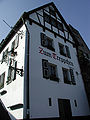
The Zur Schöne Aussicht restaurant , now the Quetsch Brewery, opened around 1907 . Around the old St. Maternus chapel, taverns established themselves in ancient half-timbered houses , such as the Treppchen , which has existed since 1820, or the Fährhaus , the clubhouse of the Cologne yacht club, which was created in 1912 from the three Michelshüschen .
The figures from the census of December 1, 1910 show that there was soon a fairly dense development. At that time, 6,329 Catholics , 2,519 Protestants , 248 Jews and 91 residents lived in the parish who did not belong to any of the major religious communities.
Later on, residential buildings in the Bauhaus style of classic modernism were built in the Rhine location, on Uferstrasse / Im Park .
The Rodenkirchen motorway bridge, built between 1938 and 1941 based on a design by Paul Bonatz for the federal motorway 4 Cologne – Aachen , also changed the appearance of the town.

In the late 20th century, projects that were often large and towering, such as the new district town hall or the “Sommershof” complex, as well as large residential complexes (e.g. Rodenkirchen residential park ) have put an end to the village's formerly more rural character.
The last remaining farm estate from the old days, Gut Schillingsrott, one of the last historical farm complexes in Rodenkirchen, was converted for residential purposes in 1997. Until then, the complex consisted of the manor house, a south wing and the north and east wings. It had a land size of 7,000 square meters.
The mayor's office of Rondorf remained as the municipality of Rondorf until it was renamed the municipality of Rodenkirchen in 1961, as this had developed into the capital. On January 1, 1975 Rodenkirchen was incorporated into Cologne by the Cologne Act .
Mayor of the Rodenkirchen community
|
|
Demographic statistics
Structure of the population of Cologne-Rodenkirchen:
- Share of under 18s: 13.6% (2014)
- Proportion of over 64-year-olds: 28.1% (2014)
- Proportion of foreigners: 12.2% (2015)
- Unemployment rate: 4.3% (2014)
Infrastructure

The business center of the district is formed by the main street from the Rodenkirchen district town hall to the Rodenkirchen motorway bridge as well as the section of Maternusstraße from Maternusplatz to the Rodenkirchen train station on Stadtbahn lines 16 and 17.
The towpath along the Rhine with its serviced boathouses, pubs and beer gardens has a high recreational value in Rodenkirchen . Who does something like quiet, goes in Forest Botanical Garden or the surrounding recreational area walking Friedenwald returning the neighborhood south to Hahnwald way limited. Both attractions are of national importance. The Cologne green belt , which separates the district from the rest of the city, is not far away and invites you to spend your free time with its walking and cycling paths and the nearby punt pond.
Sports
Due to its location on the Rhine, the main sporting focus in Rodenkirchen is on water sports . Numerous boathouses both on land and on water shape the image of the district. With the Cologne rowing club from 1877 , the Cologne rowing society 1891 and the Cologne club for water sports , whose club branches can be found along the banks of the Rhine in the direction of Marienburg, Rodenkirchen forms a stronghold of rowing within the Cologne Bay . In canoeing , the Rhein-Kanu-Club Köln 1923 and the Kanu-Club Grün-Gelb Köln are active, while the Free Watersports Association Cologne is mainly dedicated to swimming .
The largest popular sports club in the district is the Rodenkirchen 1898 gymnastics club , which, in addition to athletics and gymnastics, is also active in team sports such as basketball , football and volleyball .
religion
The three catholic churches in Rodenkirchen are:
- Chapel Alt St. Maternus ("Kapellchen") from the 10th to 12th centuries
- St. Maternus Church (1865)
- Parish Church of St. Joseph (1955)
In addition, Rodenkirchen has two Protestant churches:
- Evangelical Church of the Redeemer (1967)
- Archangel Michael Church in Michaelshoven (1955)
Attractions

- Chapel
- The red and white striped boathouse "Alte Liebe" is a popular floating excursion restaurant. Like the boathouses “Albatros” and “Rodenkirchen”, it is located in front of the “Kölsche Riviera” area on the banks of the Rhine with many groynes protruding into the Rhine, between which small bays with sandy beaches have formed.
- Maternus-wayside shrine: In a niche of the flood protection wall on the Rhine promenade stands a statue of St. Maternus, patron saint of floods and at the same time patron saint of Rodenkirchen. A first statue was erected here by Carthusian monks in 1773. The current statue dates from 1992. A grating protects it from vandalism and debris during floods.
- Gasthaus zum Treppchen
- Villa Malta
- Finken's garden
- Forest botanical garden
- Park of the Diakonie Michaelshoven
- Rhine bridge
- The Church of St. Joseph is a building by the important architects Dominikus Böhm and Gottfried Böhm . With the growth of the population in the period of industrialization, it was expected that Rodenkirchen would spread to Cologne. That is why the new St. Maternus Church was built on a flood-proof hill on the northern edge of Rodenkirchen. The place developed (due to the industrial conditions) more in a southerly direction. The population growth was so rapid that after the end of the Second World War one thought of building a new church.
- In the last year of his life, Professor Dominikus Böhm was commissioned to plan the church and the associated buildings. This church became Böhm's last completed project. The foundation stone for St. Joseph's Church was laid in 1955. The unconventional construction was completed by his son Gottfried. It could already be consecrated in 1956.
- There are two church towers: One serves as the entrance area and houses the bells, the other at the rear of the church rises above the chancel and lets light flow in from above through the numerous small windows. The Way of the Cross was designed by the sculptor Hans Karl Burgeff at the beginning of the 21st century .
To the podium, front side from the bank

Old ferry house

Maternus picture stock on the banks of the Rhine
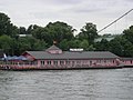
Restaurant ship Alte Liebe

St. Joseph Church


.JPG)

Honorary citizen
- Rudolf Buch, Sparkassenamtmann, since August 22, 1955
- Heinrich Erpenbach, farmer, since August 22, 1955
- Paul Renner, Dean, since November 21, 1961
- Josef Kallscheuer, Mayor, since June 23, 1964
- Everhard Stolz, mayor and council member, since June 23, 1963 (declined)
- Dr. Erwin te Reh, pastor, since December 10, 1974
Literature / sources
- Robert Wilhelm Rosellen: History of the parishes of the deanery Brühl. JP Bachem, Cologne 1887
- Karl Johannes Heyer : Rodenkirchener Impressionen , 1975–1987, with a foreword by Elmar Hillebrand , Schmitzdruck, Hillesheim, 1987
- Theodor Josef Lacomblet: The document of the Archbishop Everger of Cöln for the abbey of St. Martin there from the year 989. In: Archives for the history of the Lower Rhine. Volume 111, Issue 1, 1860, pp. 169-175
- A. Flag: History of the Cologne, Jülichen and Bergisch families. Volume 1. Cologne 1848
- Rolf Biniek: The leprosy in Bonn. In: Die Klapper. Communications from the Society for Leprosy. 9 (2001), pp. 1-7
- Art in Rodenkirchen, Art Places and Art Paths , Introduction: Karl Ruhrberg , Foreword: Eberhard Petschel, Greeting: Peter Nestler , Arbeitskreis Kunst, Cologne 50, on behalf of “1000 Years of Rodenkirchen e. V. “, Cologne, 1989
- Stefan Palm, Helmut Thielen: Rodenkirchen , Wienand Verlag, Cologne 1994. ISBN 3-87909-388-1
- Helmut Thielen (Hrsg.): Brückenbilder, three artists show their work on the Rodenkirchener Brücke , with works by Monika von Starck , Tong Hon Sang and Clemens Hillebrand , KBB Verlag, Cologne, 1994.
- Ralf Reglin: Rodenkirchen and more ... - A journey of discovery through the south of Cologne from B to Z , Ralf Reglin Verlag, Cologne 2017, ISBN 978-3-930620-73-9
Individual evidence
- ↑ Dictionary network .
- ↑ Erich Wisplinghoff (arrangement): Rheinisches Urkundenbuch : older documents up to 1100, Vol. 2, Düsseldorf 1994, No. 288.
- ↑ Martin Uhrmacher : Leprosorien in the Middle Ages and early modern times (= Historical Atlas of the Rhineland , Series VIII: Population and Social History , Supplement 5). Habelt, Bonn 2000, ISBN 3-7927-1821-9 , pp. 7-10 and pp. 15-16.
- ↑ Chronologia Cartusiae Colon
- ^ Cologne Yacht Club, the club house
- ↑ Martin Bünermann, Heinz Köstering: The communities and districts after the municipal territorial reform in North Rhine-Westphalia . Deutscher Gemeindeverlag, Cologne 1975, ISBN 3-555-30092-X .
- ↑ Inhabitants according to selected age groups - data source: City of Cologne - offenedaten-koeln.de
- ↑ Inhabitants according to selected age groups - data source: City of Cologne - offenedaten-koeln.de
- ↑ Inhabitants by type of migration background - data source: City of Cologne - offenedaten-koeln.de
- ↑ Employed and unemployed part of the city - data source: City of Cologne - offenedaten-koeln.de
- ↑ Cologne Forest and Green .
- ↑ Cologne Forest and Green .
Web links
- Official website of the city of Cologne for the Rodenkirchen district
- Information on the document of the first mention from the holdings of the LBA Marburg
- Website of the Rodenkirchen e. V.
Bayenthal | Godorf | Hahnwald | Immendorf | Marienburg | Meschenich | Raderberg | Raderthal | Rodenkirchen | Rondorf | Sürth | White | Folding rule

Berzdorf | Brauweiler | Brühl | Cheeky | Huerth | Lövenich | Pulheim | Rodenkirchen (district of Cologne) | Sinnersdorf | Tumbling | Wesseling