
Kronberg (mountain)
| Kronberg | ||
|---|---|---|
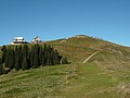
 View from the summit to the mountain station and mountain inn Kronberg |
||
| height | 1662.8 m above sea level M. | |
| location | Appenzell Innerrhoden , Switzerland | |
| Mountains | Appenzell Alps | |
| Dominance | 3.2 km → Höchnideri | |
| Notch height | 350 m ↓ Brugger Forest | |
| Coordinates | 743 005 / 239567 | |
|
||
| rock | Nagelfluh | |

The Kronberg ( 1662.8 m above sea level ) is located south of Jakobsbad in the canton of Appenzell Innerrhoden in Switzerland and is part of the Appenzell Alps . The mountain station of the cable car is in the Gonten district , while the mountain peak is in the Schwende district . The Kronberg is famous for its view of the mountains of the Alpstein , which it is in front of to the north.
Surname
In the local dialect the Kronberg is called [ˈxrobɛg], usually with a short -o-. The mountain is already occupied in the Middle Ages (end of the 9th century Chraunberch , 1071 Chranperche , approx. 1280 Cramberch ).

Cable car to the Kronberg
The summit area of the Kronberg from the south


Development
The Kronberg can be reached from Jakobsbad on several hiking trails and with the Jakobsbad – Kronberg cable car . The Kronberg can also be easily reached from Appenzell on a hike from the northeast, as well as from Schwägalp on the other, southern side of the Kronberg. In winter, a 7 km long, prepared toboggan run leads down to Jakobsbad.
As an easily climbed mountain, the Kronberg is a popular excursion destination and can also be hiked in winter on signposted snowshoe tours or winter hiking trails.
At the valley station of the Kronbergbahn there has been a summer toboggan run from the Alpine-Coaster system , a zipline and a fairytale world since June 28, 1999 . There are also two large playgrounds that are open to the public near the valley station.
Web links
- Official website
- Youtube: Panoramic view from Kronberg (1663 m)
- Interactive spherical panorama from the summit of Kronberg
Individual evidence
- ^ National map of Switzerland 1:25 000, sheet 1115 Säntis, 2004 edition. Publisher: swisstopo
- ^ Helmut Dummler: Appenzeller Land . The most beautiful valley and mountain hikes. 50 tours. 6th edition. Bergverlag Rother, Munich 2008, ISBN 978-3-7633-4086-6 , p. 36 .
- ^ S. Sonderegger: The place and field names of the country of Appenzell, Bd. I: 210, Frauenfeld 1958
- ↑ The longest toboggan run in Eastern Switzerland under "Winter" on kronberg.ch (accessed on June 26, 2012)
- ↑ History on kronberg.ch (accessed on July 19, 2018)