
Frauensee
|
Frauensee
City of Bad Salzungen
|
|
|---|---|
 |
|
| Height : | 280 m |
| Area : | 19.29 km² |
| Residents : | 823 (December 31, 2016) |
| Population density : | 43 inhabitants / km² |
| Incorporation : | 6th July 2018 |
| Postal code : | 36469 |
| Area code : | 036963 |
 Frauensee in the northwest of the urban area
|
|
Frauensee is a district of the town of Bad Salzungen in the Wartburg district in Thuringia .
geography
Naturally, Frauensee lies in a side valley of the central Werra , between the Thuringian Forest and the Rhön on the lake of the same name .
Former parish structure

In addition to Frauensee, the Frauensee district includes the village of Springen and the small settlements of Knottenhof , Möllersgrund and Schergeshof . The two small settlements Knottenhof and Schergeshof are located south of the village in the direction of Kieselbach . On June 30, 2009 there were 10 residents in Knottenhof, 53 in Möllersgrund, 10 in Schergeshof and 134 in Springen.
Townscape


The Frauensee is characteristic of the place. The historical location of Frauensee was created on the north-western bank of the lake around a former monastery site, which was converted into a palace complex after secularization . There are still numerous examples of the original half-timbered architecture of the houses in the town center. In the 20th century, the place then experienced extensive expansions as a result of the emerging tourism. A little away from the main town, several pits for potash mining were built in the valleys around Springen at the beginning of the 20th century .
Neighboring places
Frauensee borders in the west and north on the districts of Vitzeroda , Gospenroda and Wünschensuhl of the city of Werra-Suhl-Tal and in the north-east on the Gerstung district of Marksuhl . To the east follows the Bad Salzunger district Dönges . In the south, the districts of Kieselbach and Dorndorf join the Krayenberg community . Belonging to the city of Vacha is the corridor of the Heiligenroda desert as a south-western neighbor.
Geology and mineral resources
The place is on the northern edge of the Werra potash district ; Potash was extracted in the Springen pits.
From a geological point of view, the place lies in a very active natural subsidence zone with sinkholes . This was also the reason for the emergence of the three large lakes with no outflow, Frauensee, Hautsee and Albertsee . Sandstone quarries were created in several places in the area above ground.
mountains

The landscape around Frauensee is characterized by the Frauenseer forest with peaks, hills and mountains, including: Lehnberg ( 447.7 m above sea level ), Gertenberg ( 338 m above sea level ), Buchenberg ( 366.4 m above sea level ), Schälrück ( 388.1 m above sea level ) and Langer Rück ( 373.9 m above sea level ). The Schafberg ( 308.2 m above sea level ) is located directly on the outskirts of Frauensee. The region is part of the Frauensee hill country and forms the northern part of the Salzunger Werrabergland . It is located to the right (north or east) of the Werra, roughly in the triangle between Bad Salzungen, Philippsthal and Berka. From a larger scale, it is part of the East Hessian mountainous region.
Waters

The water system consists of the Frauensee, which originally had no outflow, but which in 1774 was considerably reduced in size due to the lowering of the water level and the construction of a drainage tunnel. The Kambach is a 7000 meter long right tributary of the Werra , it has its headwaters in the forests around Springen. The Kieselbach is an approximately 6000 meters long right tributary of the Werra, whose headwaters are located south of Frauensee and into which the drainage tunnel of the Frauensee, completed in 1774, flows.
Since 2008 an overflow has been created between the small and large lake, so that the lakes are connected again for the first time since 1774.
To improve the water quality of the Frauensee, a new sewage treatment plant was put into operation south of the locality in 2009 . Since then, for the first time, the majority of the wastewater occurring in Frauensee is no longer fed into the lake.
history
The place goes back to the Frauensee monastery founded in 1189 , a Cistercian nunnery on an island in the Frauensee lake of the same name, which was first mentioned as Lacus sankte Mariae (Lake of St. Mary). In 1202, the Thuringian Landgrave Hermann I appointed a knight from Salzung as guardian of the monastery. With the place Frauensee as well as the places and individual farms Abteroda, Gasteroda, Heiligenroda, Gospenroda, Fülleroda, Vitzeroda, Baueshof, Mölmeshof, Josthof, Mittelhof, Knottenhof, numerous new settlements emerged in the immediate vicinity as part of inland colonization. After the destruction of the monastery in the Peasants' War in 1525 and the accompanying secularization , the monastery property came to the Landgraviate of Hesse , sovereign rights were shared between Hesse and Saxony.
In 1816 the Frauensee office came to the Duchy of Saxony-Weimar-Eisenach , where Frauensee was assigned to the Eisenach district. The main occupation of the residents was agriculture, especially wool production. Frauensee had extensive agricultural land, which is probably due to the equipment in the former monastery. Around 1900 the place became a destination for summer visitors . In 1902 there were 374 inhabitants, in 1955 there were 1422 inhabitants.
During the Second World War there was a subcamp of the Buchenwald concentration camp in the Springen district , where prisoners of war had to work in a Wintershall AG mine .
In 1950 the town, which had previously been in the Eisenach district , became part of the newly formed Bad Salzungen district , and in 1994 it became part of the Wartburg district . On July 6, 2018, Frauensee was incorporated into the city of Bad Salzungen.
politics
Former councilor
The last municipal council from Frauensee consisted of eight councilors and councilors.
- Frauensee citizens' list: 8 seats
(As of: local elections on May 25, 2014 )
Former mayor
The honorary mayor Rudolf Reitzig was re-elected on June 6, 2010.
partnership
There is a partnership with the climatic health resort of Ronshausen in Hessen .
Culture and club life

Frauensee owns a large number of clubs.
The Natur- und Heimatverein Frauensee e. V. was founded in 1991. The approximately 30 members look after the local history museum in the castle and the extensive network of hiking trails around the village. The ecumenical hiking trail St. Jacobus and the Lulluspfad as two supraregional trails touch Frauensee. On the initiative of the association, carnival has been celebrated in Frauensee again since 1992.
The Frauensee Church Choir was founded as a mixed choir in 1983 ; this choir is primarily dedicated to the needs of church life.
The SV 1930 Frauensee sports club was founded in 1930 as a football club and currently has around 150 members.
The Hallalli Frauensee hunting association indulges in hunting - they look after a 1,510 hectare hunting area in the Frauensee district. The Aal club is committed to fishing ; the club was re-established in 1991.
The first fire protection and fire brigade association was established together with the neighboring town of Dönges in the 1880s. Today's fire brigade association Frauensee e. V. was founded in January 1990 and in 2002 had a membership of 49 comrades.
In 1990 the IGBCE interest group was established as a local branch of the trade union and association of active and former potash miners.
A traditional fair takes place in Frauensee every year . This is organized by the young people of the community and held in the hall belonging to the “Zum golden Stern” inn.
Buildings and sights
Monastery complex and castle

The castle in Frauensee

Aerial view of Frauensee Castle


In preparation for the local anniversary, archaeological excavations were carried out in the castle courtyard, traces and remains of walls of the former Frauensee monastery were found . Today's castle, built between 1632 and 1634 by Landgrave Wilhelm von Hessen-Kassel, is the seat of the municipal administration and houses the local history museum.
St. Mary's Church

The St. Mary's Church

Aerial view of St. Mary's Church

St. Mary's Church


The church, built in neo-Gothic style in the years 1855–1857, was built on a new piece of land that was gained by artificially lowering the lake. It was also named "Marien-Kirche". In 1895, the parish donated a new interior painting to embellish the building.
From 1983 to 1987 the church was extensively renovated. Tower, roof, tower head and weather vane were renewed, lightning protection and a new electrical system with bench heating was installed and the pulpit was lowered by 1.20 m, the interior decoration and the lead-glazed windows destroyed in the Second World War were reconstructed.
Frauensee with parks
As early as 1900, the idea of opening up the Frauensee, the nearby Hautsee with the mysterious floating island and other sights in the area for tourism was born. Numerous viewpoints and hiking trails were created in the area, a bathing establishment was built on the lake and numerous villas and summer houses were built on the outskirts.
Old school
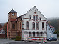
The old school

Aerial view of the old school with Frauensee in the background


Opposite the castle is the old village school, a clinker brick building from 1906.
Historical monuments

- Since 1985, a memorial stone in the Springen district has been commemorating 14 deaths among the 500 forced laborers who had to perform blasting, clearing and concreting work in the potash pit during the Second World War . A memorial stone on the site of mine I has been referring to this event since 1975
Natural monuments
The Dolinen slopes nature reserve is located northwest of the village and has a total area of 75.25 hectares . It was expelled on December 9, 1996.
economy

In Frauensee, the structural change in the economy has led to a reorientation towards tourism. The dairy cattle facility of the former LPG is located on the western outskirts of Frauensee ; the stables, pastures and fields are now used by the Krayenburg agricultural cooperative from Tiefenort. Most of the former potash industry pits near Springen have been dismantled.
traffic
Road traffic
Frauensee is located about 10 kilometers southeast of junction 36 Gerstungen of federal motorway 4 , this can be reached via Gospenroda and Berka / Werra on state road 1022 . The federal road 84 leads about 3 kilometers east of Frauensee to Vacha , to the district town of Bad Salzungen (14 km) or to Eisenach (25 km).
Rail transport
The nearest train stations are in Marksuhl ( South Thuringia Railway Eisenach-Bad Salzungen) and Gerstungen ( Thuringia Railway Eisenach-Bebra). Connection to the ICE network can be found at Eisenach train station .
Public transport
Bus routes operated by the Wartburgmobil transport company connect the town with Vacha , Geisa , Bad Salzungen , Gerstungen and Eisenach .
Web links
Individual evidence
- ↑ a b c Festschrift 800 years of Frauensee . Frauensee 2002.
- ↑ Information .. In: District Office Wartburgkreis (Hrsg.): Official Gazette of the Wartburgkreis from 10 August 2010 . Bad Salzungen 2010, p. 14 .
- ^ Geyer, Jahne, Storch: Geological sights of the Wartburg district and the independent city of Eisenach . In: District Office Wartburgkreis, Lower Nature Conservation Authority (Hrsg.): Nature conservation in the Wartburgkreis . Booklet 8. Printing and publishing house Frisch, Eisenach and Bad Salzungen 1999, ISBN 3-9806811-1-4 , p. 109-112 .
- ↑ Official topographic maps of Thuringia 1: 10,000. Wartburgkreis, district of Gotha, district-free city of Eisenach . In: Thuringian Land Survey Office (Hrsg.): CD-ROM series Top10 . CD 2. Erfurt 1999.
- ↑ New connection to the large lake , local edition Bad Salzungen from August 9, 2008
- ↑ Sewage treatment plant away from living room , local edition Bad Salzungen from October 13, 2009
- ^ Paul Luther: Materials for local history lessons - Bad Salzungen district, Suhl district . Ed .: Council of the Bad Salzungen District, Department of Public Education. Bad Salzungen 1959, structure of the district of Suhl (overview of the places and population of the districts), p. 5-11 .
- ↑ Thuringian Law and Ordinance Gazette No. 7 2018 of July 5, 2018 , accessed on July 6, 2018
- ↑ 2014 municipal council elections in Thuringia - final result. The regional returning officer, accessed on February 12, 2020 .
- ↑ Mayoral election on 06.06.2010 in Thuringia - final result. The regional returning officer, accessed on February 12, 2020 .
- ↑ Festschrift 800 years of Frauensee . Frauensee 2002. pp. 16-39
- ↑ Festschrift 800 years of Frauensee . Frauensee 2002. p. 5
- ↑ Thuringian Association of the Persecuted of the Nazi Regime - Bund der Antifaschisten und Studienkreis deutscher Resistance 1933–1945 (Ed.): Heimatgeschichtlicher Wegweiser to sites of resistance and persecution 1933–1945 . In series: Heimatgeschichtliche Wegweiser Volume 8 Thuringia, Erfurt 2003, p. 322, ISBN 3-88864-343-0
- ^ Klaus Schmidt: The Wartburg district. Nature and landscape . In: Wartburgkreis (Ed.): Nature conservation in the Wartburgkreis . tape 7 . Printing and publishing house Frisch, Eisenach and Bad Salzungen 1999, p. 87 .
Bad Salzungen | Dönges | Allendorf village | Ettenhausen an der Suhl with Hetzeberg | Frauensee with Knottenhof , Möllersgrund and Schergeshof | Hämbach | Hohleborn | Kaltenborn with Sorghöfe | Monastery | Langenfeld | Oberrohn with Hüttenhof and Röhrigshof | Jumping | Tiefenort with Weißendiez | Unterrohn | Wildsprachtroda