
Wildsprachtroda
|
Wildsprachtroda
City of Bad Salzungen
Coordinates: 50 ° 48 ′ 8 ″ N , 10 ° 14 ′ 46 ″ E
|
|
|---|---|
| Height : | 263 m above sea level NN |
| Incorporation : | July 1, 1950 |
| Postal code : | 36433 |
| Area code : | 03695 |
 Wildsprechtroda in the southeast of the urban area
|
|
 Partial view of the place from the northwest (2012)
|
|
Wildsprechtroda is a southern district of Bad Salzungen in the Wartburg district .
geography
Wildsprechtroda is located on the northern edge of the Thuringian Rhön , immediately southeast of the core town of Bad Salzungen. The Schneidersberg, which adjoins it to the south, is part of the district, the spacious area of the Werra Valley barracks lies in the east and the residential and commercial estates of the core city are in the north and west.
The place is located on the Pfitzbach , a left tributary of the Werra , about 300 m east of the town there is the Buchensee , a water-filled sinkhole and the roughly equal oat pond in a swampy meadow. The height of Wildsprechtroda is given as 265 m above sea level . The historical location is around the castle built as a low castle and the church built on a hill.
history
In the 13th century, Wildsprechtroda, located in the soft landscape of the city of Salzungen, was the home of a Fulda ministerial and Salzung family of Burgmanns. It was named after the place Willebrechteode . The well-to-do family donated their entire fortune to founding the Georgenzell Provost (near Rosa) . The place Wildsprechtroda with the Niederungsburg, on the site of today's castle , came first to the dynasts of Frankenstein . In the Frankenstein sales letter, Wildsprechtroda 1330 is recorded, and the next fief owners are Parakeet and Wilhelm Marschalk . They build a permanent house there - the Rudolphshof . From 1432 the Lords of Buttlar also received a share from Wildsprechtroda. Your first castle seat was the old castle - probably the Frankenstein castle. Today's castle was built in the Renaissance style in the 16th century and was the seat of the Buttlar-Wildprechtoda sidelines, which later also owned the neighboring village of Leimbach , five kilometers away . It consists of three buildings that are grouped around a tiny atrium and was once surrounded by a protective moat. The castle is again in the family ownership of the Buttlars and is being restored as far as possible.
After the Thirty Years' War, the Rudolphshof was also the second manor in the hands of the Butlers. As the sole patron saint of Wildsprechtroda, the Buttlars donated the building of today's church in 1683 . It replaces the existing Gothic chapel, which was damaged during the looting and devastation during the Thirty Years' War. (Buttlar was changed to Butler)
At the beginning of the 19th century, a geographical description contains the following information: Wildsprechtroda "- 224 inhabitants 112 males, 112 females. Gender. 190 buildings in total, 42 inhabited houses. Village, ½ hour south of Salzungen, on part of the armach coming from Langenfeld, with 2 manors, which are subject to civil jurisdiction over the place, branch of Salzungen with its own school ”.
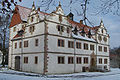
Wildsprechtroda Castle

The church


literature
- Harry Gerlach: Bad Liebenstein, Bad Salzungen (= tourist hiking atlas. ). 3rd, expanded edition. Tourist-Verlag, Berlin et al. 1988, ISBN 3-350-00218-8 , p. 66.
- Thomas Biesel, Ella Fritsch, Margot Wilke: Salzungen. Historical excursion through the Salzunger Land . Frankensteingemeinde, Bad Salzungen 1992, p. 64 .
- City administration Bad Salzungen (Ed.): Festschrift for the city anniversary of 1225 years Bad Salzungen . Bauer & Malsch-Druck Immelborn, Bad Salzungen 2000, p. 64 .
- Hartmut Ruck et al .: Bad Salzungen with a chronological excerpt from the city's history and city center map, important information about the city and company portraits. ETRO-Verlag, Bad Sooden-Saalmünster sa (probably 2000), p. 72.
- Tobias Günther, Hartmut Ruck: Bad Salzungen . Stadt-Bild-Verlag, Leipzig 2005, ISBN 3-937126-13-9 .
Web links
Individual evidence
- ↑ Official topographic maps of Thuringia 1: 10,000. District of Gotha, Wartburg district, district-free city of Eisenach . In: Thuringian Land Survey Office (Hrsg.): CD-ROM series Top10 . CD 2. Erfurt 1999.
- ↑ a b Hans Patze , Peter Aufgebauer (ed.): Handbook of the historical sites of Germany . Volume 9: Thuringia (= Kröner's pocket edition . Volume 313). 2nd, improved and supplemented edition. Kröner, Stuttgart 1989, ISBN 3-520-31302-2 , p. 489.
Bad Salzungen | Dönges | Allendorf village | Ettenhausen an der Suhl with Hetzeberg | Frauensee with Knottenhof , Möllersgrund and Schergeshof | Hämbach | Hohleborn | Kaltenborn with Sorghöfe | Monastery | Langenfeld | Oberrohn with Hüttenhof and Röhrigshof | Jumping | Tiefenort with Weißendiez | Unterrohn | Wildsprachtroda