Gospenroda
|
Gospenroda
City of Werra-Suhl-Tal
Coordinates: 50 ° 54 ′ 27 ″ N , 10 ° 6 ′ 7 ″ E
|
|
|---|---|
| Height : | 256 (250–280) m above sea level NN |
| Area : | 9.29 km² |
| Incorporation : | March 18, 1994 |
| Incorporated into: | Berka / Werra |
| Postal code : | 99837 |
| Area code : | 036922 |
|
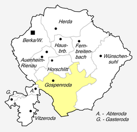
Location of Gospenroda in the Werra-Suhl valley
|
|
|
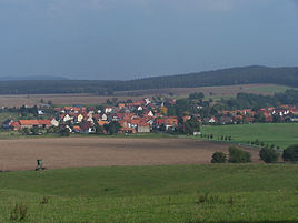
Partial view of the location from the west
|
|
Gospenroda is a district of the town of Werra-Suhl-Tal in the Wartburg district in Thuringia .
geography
Gospenroda is five kilometers southeast of the administrative headquarters Berka / Werra on the southern edge of the Horschlitter Mulde . The highest point in the area is a wooded knoll with the legendary " Juror Oak" ( 403.1 m above sea level ). The total area of the district is 9.29 km². The mountains Landerskopf ( 362.7 m above sea level ), Weinberg ( 355.9 m above sea level ), Salzberg ( 305.6 m above sea level ) and Abterodaer Berg ( 307.7 m above sea level ) form the southern edge this sink. The partly wooded mountains are part of the Frauensee forest . The "main ditch", a left tributary of the Suhl , drains the community corridor.
history
In the Middle Ages, Gospenroda belonged to the area of the Hausbreitenbach office , the clearing settlement was not far from the Hohen Straße, which led west of the village from Vacha via Abteroda to Berka / Werra. The first mention of the place Gospenroda took place in the document book of the Frauensee monastery in 1239.
In 1733 Gospenroda was incorporated into the Hessian office of Frauensee after Landgrave Friedrich von Hessen dropped his claims to the office of Hausbreitenbach, which was administered jointly with Sachsen-Eisenach . a. received the place. As a result of the Congress of Vienna , Gospenroda came to the Grand Duchy of Saxony-Weimar-Eisenach with the Frauensee office in 1816 .
C. Kronfeld published geographic and statistical information about the place in 1879: Gospenroda is a village with 63 houses and 351 inhabitants. The total area of the village is 306.96 ha, of which farms and gardens account for 8.34 ha, meadows 28.41 ha, arable land 217.34 ha, forest 3.76 ha, ponds, streams and rivers 0.29 ha, paths , Drifts and fruit trees 48.8 ha. The livestock consists of 13 horses, 154 cattle, 278 sheep, 68 pigs, 56 goats and 37 bee colonies.
The Thuringian Ordinance of February 16, 1994 dissolved the communities of Fernbreitenbach, Gospenroda, Herda, Horschlitt and Vitzeroda and incorporated them into the city of Berka / Werra with effect from March 18, 1994. This went into the city on January 1, 2019 Werra-Suhl-Tal.
Attractions
- The village church was built in 1784 in half-timbered style.
Individual evidence
- ^ Waldemar Küther : Document book of the Frauensee monastery. 1202–1540 (= Central German Research. 20, ISSN 0544-5957 ). Böhlau, Cologne et al. 1961.
- ^ Constantin Kronfeld: Regional Studies of the Grand Duchy of Saxony-Weimar-Eisenach. Part 2: Topography of the Land. Böhlau, Weimar 1879, p. 362 .
- ^ Thuringian ordinance on the dissolution of the communities Fernbreitenbach, Gospenroda, Herda, Horschlitt and Vitzeroda and their incorporation into the town of Berka / Werra of February 16, 1994 (GVBl p. 288).
- ↑ Thuringian Law and Ordinance Gazette No. 14/2018 p. 795 ff. , Accessed on January 2, 2019
- ↑ The Church . At eisenach.ekmd-online.de, accessed on September 30, 2014.

