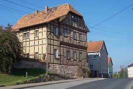
Hausbreitenbach
|
Hausbreitenbach
City of Werra-Suhl-Tal
Coordinates: 50 ° 56 ′ 20 ″ N , 10 ° 6 ′ 12 ″ E
|
|
|---|---|
| Height : | 215 m above sea level NN |
| Incorporation : | July 1, 1946 |
| Incorporated into: | Herda |
| Postal code : | 99837 |
| Area code : | 036922 |
|
Location of Hausbreitenbach in the Werra-Suhl valley
|
|
|
Half-timbered house in the center of the village
|
|
Hausbreitenbach is a district of the city of Werra-Suhl-Tal in the Wartburg district in Thuringia . Hausbreitenbach was incorporated into Herda on July 1, 1946 .
geography
Hausbreitenbach is located 2 km east of the Berka / Werra administrative headquarters on the lower reaches of the Suhl . The geographic height of the place is 215 m above sea level. NN .
history
Archaeological finds from sand and gravel mining on Eichelberg and not far from the Werraaue are evidence of the prehistoric settlement of the corridor. The water castle Breitenbach was the origin of the place Hausbreitenbach and since the high Middle Ages the administrative seat of the office Hausbreitenbach belonging to the monastery Hersfeld . The residences of the Burgmannen were just south of the Hausbreitenbach moated castle on today's main street. From the church chronicle of Fernbreitenbach, a place Oberbreitenbach is known as a desert , which was located on the Fernbreitenbach field boundary.
The Thuringian landgraves concluded a contract with the abbot of Hersfeld in 1354, according to which the house and office of Breitenbach was jointly administered with the village of Berka. The Thuringian, later Saxon bailiff had his seat in Hausbreitenbach, later Gerstungen, the hersfeld resident lived in Berka / Werra.
In the 16th century the region around Herda was a center of the Anabaptist movement . As the leader of this movement, the free farmer Fritz Erbe was captured and first imprisoned in the Hausbreitenbach moated castle, then transferred to Eisenach, where he was tried and later died in the dungeon of the Wartburg . C. Kronfeld published regional and statistical information on the place in 1879: Hausbreitenbach is a village with 16 houses and 88 inhabitants. The total area of the village is 220.63 ha, of which farms and gardens account for 5.94 ha, meadows 21.4 ha, arable land 163.7 ha, forest 3.5 ha, ponds, streams and rivers 1.7 ha, paths , Drifts and fruit trees 24.1 ha. The livestock includes 19 horses, 97 cattle, 367 sheep, 31 pigs and 7 goats.
The manor on the northern outskirts was one of the largest farms in the Berka / Werra area. A few outbuildings have been preserved from the nationalized estate. After the Second World War, Hausbreitenbach was in the border area with Hesse, the district and territorial reform carried out in 1954 led to the merger with the neighboring town of Herda to Herda-Hausbreitenbach . The close connection to Herda still exists today, in the meantime the two districts have moved closer together with new buildings.
The Thuringian ordinance of February 16, 1994 resulted in the dissolution of the communities Fernbreitenbach, Gospenroda, Herda, Horschlitt and Vitzeroda and their incorporation into the city of Berka / Werra. This opened on January 1, 2019 in the city of Werra-Suhl-Tal.
literature
- Elisabeth Ziegler: The territory of the imperial abbey of Hersfeld from its beginnings to 1821 (= writings of the institute for historical regional studies of Hesse and Nassau. Item 7, ZDB -ID 506862-9 ). Kommissionsverlag NG Elwertsche Buchhandlung, Marburg 1939, pp. 135–140.
- Berka (Werra) community, castle site. In: Thomas Bienert: Medieval castles in Thuringia. 430 castles, castle ruins and fortifications. Wartberg-Verlag, Gudensberg-Gleichen 2000, ISBN 3-86134-631-1 , p. 319.
- Hausbreitenbach. In: Michael Köhler: Thuringian castles and fortified prehistoric and early historical living spaces. Jenzig-Verlag Köhler, Jena 2001, ISBN 3-910141-43-9 .
Individual evidence
- ↑ Official topographic maps of Thuringia 1: 10,000. Wartburgkreis, district of Gotha, district-free city of Eisenach . In: Thuringian Land Survey Office (Hrsg.): CD-ROM series Top10 . CD 2. Erfurt 1999.
- ^ Constantin Kronfeld: Regional Studies of the Grand Duchy of Saxony-Weimar-Eisenach. Part 2: Topography of the Land. Böhlau, Weimar 1879, pp. 362–363 .
- ^ Thuringian ordinance on the dissolution of the communities Fernbreitenbach, Gospenroda, Herda, Horschlitt and Vitzeroda and their incorporation into the town of Berka / Werra of February 16, 1994 (GVBl p. 288).
- ↑ Thuringian Law and Ordinance Gazette No. 14/2018 p. 795 ff. , Accessed on January 2, 2019


