Roldisleben
|
Roldisleben
City of Rastenberg
Coordinates: 51 ° 10 ′ 30 ″ N , 11 ° 22 ′ 54 ″ E
|
||
|---|---|---|
| Height : | 210 m above sea level NN | |
| Incorporation : | March 25, 1994 | |
| Postal code : | 99636 | |
| Area code : | 036377 | |
|
Location of Roldisleben in Thuringia |
||
|
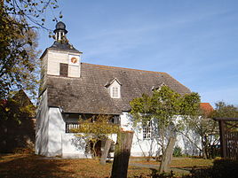
Protestant church
|
||
Roldisleben is a district of the town of Rastenberg in the Sömmerda district in Thuringia .
geography
Roldisleben is located west of Rastenberg and south of Bachra and is surrounded by an agricultural corridor. To the north of Bachra, the Hohe Schrecke borders the corridor and further east there are the foothills of the Finn . Roldisleben can be reached via the state road 1057 and the local connecting road.
history
The village was first mentioned in documents in 1312. Again and again the population had to suffer from the wars. So it is reported in the chronicle of the village that the Thuringian Count War 1342-1346 had devastating effects on the village. From 1445 to 1451 the civil war followed , many people died. In 1450 the village burned down completely. In the course of the Thirty Years' War the place was destroyed several times and was last rebuilt in 1649. In the Napoleonic Wars between 1806 and 1813, Roldisleben again suffered from looting by troops passing through.
Until 1815 Roldisleben belonged to the Electoral Saxon Office Eckartsberga . The decisions of the Congress of Vienna the place to Prussia came only in 1816 the district Eckartsberga in the administrative district of Merseburg of the Province of Saxony assigned to which he belonged until 1944th Ecclesiastically, Roldisleben came to Ephorie Heldrungen in 1815 when the Kingdom of Saxony was divided . In the autumn of 1828, several courtyards in the village were damaged by a major fire. From 1856 to 1859 the farmers separated the corridor. In the First World War, 15 inhabitants lost their lives. American troops marched into the town on April 11, 1945. Then began the era of the GDR and the integration of farmers into agricultural policy . With the political change after 1990, new forms of ownership for work in the countryside were found.
Individual evidence
- ^ Wolfgang Kahl : First mention of Thuringian towns and villages. A manual. 5th, improved and considerably enlarged edition. Rockstuhl, Bad Langensalza 2010, ISBN 978-3-86777-202-0 , p. 237.
- ↑ a b Historical documentations about Roldisleben ( Memento of the original from March 12, 2012 in the Internet Archive ) Info: The archive link was automatically inserted and not yet checked. Please check the original and archive link according to the instructions and then remove this notice. at www.Rastenberg.de, accessed on March 6, 2012
- ↑ Places of the Prussian district Eckartsberga in the municipality register 1900
- ↑ a b City districts of Rastenberg on the city's website ( memento of the original from March 12, 2012 in the Internet Archive ) Info: The archive link has been inserted automatically and has not yet been checked. Please check the original and archive link according to the instructions and then remove this notice. Retrieved March 6, 2012

