
Bachra
|
Bachra
City of Rastenberg
|
||
|---|---|---|
 |
||
| Height : | 210 m above sea level NN | |
| Residents : | 612 (December 21, 2001) | |
| Incorporation : | March 25, 1994 | |
| Postal code : | 99636 | |
| Primaries : | 036378, 036377 | |
Location of Bachra in Thuringia |
||
.JPG) Church of St. Dionysius in Bachra (2010)
|
||

Bachra has belonged to the town of Rastenberg since 1994 and has 612 inhabitants ( as of December 21, 2001 ) in the northeast of the Sömmerda district in northern Thuringia .
location
Bachra is south of the Hohe Schrecke . The Schafau brook flows in the southern part of the village and is dammed up to form the Bachra retention basin .
history
On the northeastern edge of the Thuringian Basin near Bachra on an oval hilltop of the Finn is the castle site of the former Tittelsburg, today a ground monument . Remnants of the building are no longer there, but the land section of 10 × 30 m, which was protected by a wall and a surrounding ditch. Not far from this castle site is the Wallburg Platte . It is believed that both castles controlled and secured the traffic routes in this part of the Finn. There are several ravines in the area and indicate the course of the old traffic routes from Erfurt towards Memleben to the Imperial Palace from the 10th century.
First mention
Before 1157 the place Bachere was first mentioned in a document (located on the creek) (source: Otto Dobencker : Regesta diplomatica necnon epistolaria historiae Thuringiae ). Before 1260, the Bachra monastery was founded by the Cistercian nuns.
Late Middle Ages and Early Modern Times
In the late Middle Ages there was a frequent change of aristocratic rule over the place that belonged to the "Herrschaft Frohndorf ". In 1505 Hans von Werthern bought the village. From 1607 it was owned by the Werthern / Wiehe line. In 1598 and in the Thirty Years' War the plague claimed many victims in the village. Around 1635 the local priest and local researcher Adolar Erich made the first general map of Thuringia, the Tyring map or country table . It was used until the 18th century.
Modern times
Bachra belonged to the Electoral Saxon Office Eckartsberga until 1815 . By the resolutions of the Vienna Congress is the place to come Prussia in 1816 the district Eckartsberga in the administrative district of Merseburg of the Province of Saxony assigned to which he belonged until 1944th In 1834 a conflagration destroyed large parts of the village. In 1864/65 the castle was rebuilt by the Werthern family. In the time of the empire after 1870/71 Bachra experienced a considerable economic boom, also with the construction of several industrial companies connected with agriculture. In 1912 the place was electrified. In 1914 the Finnebahn was opened with a train station in Bachra. The First World War claimed 24 victims among the soldiers in the village. The civil war-like unrest known as the March Fighting in Central Germany had also affected the village of Bachra. On March 30, 1921, a firefight took place in the corridor of Bachra between an approximately 140-strong marching group of armed workers from Leuna and a unit of the mounted security police from Erfurt , who were supposed to thwart the further march of the combat group into the Mansfeld district. Six workers were killed in the battle. In 1928 the community joined the Werthern's drinking water network, which had existed since 1913. The volunteer fire brigade was founded in 1935 . In the Second World War there were 34 dead and missing from the place. During the war, evacuees from the aerial warfare areas and, from 1944 onwards, refugees from the eastern areas.
present
In early April 1945 the US Army occupied Bachra. A Hitler Youth who shot down a US tank with a bazooka was shot after capture, as was a German major. They were buried in the place.
The Americans were replaced by the Red Army in early July . The castle and manor (263 hectares) were expropriated without compensation, the von Werthern family expelled and banned from the district. The castle inventory fell victim to looting. The castle became a quarantine station, a party school of the SED in 1946 and a primary school from 1951. In the course of the land reform in the Soviet occupation zone , the land was divided among new farmers who later formed the LPG "Frohes Schaffen" together with the previous owners . The Hohe Schrecke was a restricted Soviet military area for 46 years . In 1947 the Finne-Bahn had to cease operations, and in 1948 the tracks and facilities were dismantled as a reparation payment for the Soviet Union .
On July 1, 1950, the previously independent community of Schafau was incorporated. In 1952, Bachra and the Sömmerda district were incorporated into the new Erfurt district. In 1964 a polytechnic high school opened its doors in Bachra, which existed until 1991. In 1970 a memorial for those who fell in March was built near the western entrance to the town; the memorial plaque was removed at the turn of 1989.
In 1991, the Soviet military camp located in the Hohe Schrecke was disbanded and the corresponding contaminated sites had to be removed. In 1992 all houses received telephone connections. In 1993, Bachra was incorporated into Rastenberg. In 2001 the kindergarten had to be closed due to the drastic decline in the birth rate and the primary school closed earlier. In 2002, the Kinderland Bachra e. V. , an association founded by a parents' initiative, has reopened the kindergarten.
Population development
Development of the population:
|
Economy and Infrastructure
Bachra is located on the B176 as a feeder road for the A9 and A71 as well as south over the B85 via Weimar to the A4 .
Attractions
- Evangelical Church of St. Dionysius : The single-nave church with a tower over the western half was built in several phases and has a sacristy, which was probably built in 1539. The rectangular windows were used around 1700. Major renovations were made in 1830. Inside the church there are four tombstones belonging to the von Werthern family. Since 1988 two plaques have been commemorating the 34 soldiers who died and went missing in the Second World War. In 1923, a memorial for the 24 fallen soldiers of the First World War was erected in front of the church.
- The so-called castle is a two-wing, three-storey building on an angular floor plan with a neo-Gothic, partly stone-faced facade and tower, it was built in 1864/65. It was owned by the von Werthern family until 1945 , and has been privately owned since 2000. The castle wall was partly laid down in 1970 for the extraction of natural stone for a memorial to the “March fallen” of the Central German uprising. An adjacent green area originally served as a palace park.
- Heimatstube furnished by the Heimat- und Kulturverein in 2001
- Victorious linden tree from 1815: was planted after the victory over Napoleon near Waterloo in 1815
- Graves of six “March fallen” (Leuna workers) of the Central German uprising in 1921 in the cemetery
- Heroes' grove with commemorative linden trees below the tower windmill for those killed in the First World War
- The plaque of a memorial for the “March fallen” erected in the GDR era in 1970 at the western entrance to the town has been in the home parlor since the “fall of the march”
- Several notable courtyards
- Former half-timbered station of the Finnebahn from 1913
- Former tower windmill from 1828, without blades since the 1950s, on the road to Olbersleben
- Retention basin of the Schafau: built from 1969 to 1971, formerly including a pumping station for large-scale field irrigation, today under the management of the water management office only as flood protection and for anglers.
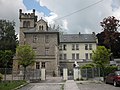
Castle in Bachra

War memorial in Bachra in the churchyard

Memorial stone for 6 fallen insurgent Leuna workers from 1921


Tourism
- Excursions to the neighboring Hohe Schrecke
- Bachra is located on the hiking and cycling path from Ostramondra to Rastenberg on the embankment of the former Finnebahn
- Station on the Mühlen-Wanderweg with the former tower windmill on the road to Olbersleben
- 2009 Inauguration of the approx. 3 km distant Way of the Cross with 14 stations, to be reached via Obertorstraße / Lossaer Straße along the Hirschbach
societies
- Association for Fanfare Music Bachra eV
- Fire Brigade Association Bachra eV
- Heimat- und Kulturverein Bachra-Schafau eV
- Mixed choir Bachra eV
- Kinderland Bachra eV
Personalities
- Georg Cramer (born June 12, 1610 in Bachra; † February 15, 1676 in Leipzig), educator
Web links
- Page about the history of Bachra on the website of the city of Rastenberg
- Private website about Bachra
Individual evidence
- ↑ Michael Köhler : Thuringian castles and fortified prehistoric and early historical living spaces. Jenzig-Verlag Köhler, Jena 2001, ISBN 3-910141-43-9 , pp. 248 and 201.
- ↑ Friedhelm Jürgensmeier , Regina Elisabeth Schwerdtfeger: The monastery and nunnery of the Cistercians in Hesse and Thuringia (= Germania Benedictina . Vol. 4). Volume 1. EOS-Verlag, St. Ottilien 2011, ISBN 978-3-8306-7450-4 , pp. 193-196.
- ↑ Places of the Prussian district Eckartsberga in the municipality register 1900
- ↑ a b Anette Rudolph: A memorial was set up for the Leuna fighters . In: The people . Erfurt April 30, 1983.
- ↑ Jürgen Möller: The fight for northern Thuringia in April 1945. The fighting in the area north of Mühlhausen-Langensalza and the advance of the V. US Corps from the Werra through the districts of Heiligenstadt, Worbis and Sondershausen to Unstrut and on to the Saale (= end of the war in Central Germany 1945. Vol. 1). 2nd, edited edition. Rockstuhl, Bad Langensalza 2010, ISBN 978-3-86777-212-9 , pp. 134-135.
- ↑ Population of the municipality of Bachra
- ↑ a b Stephanie Eißing et al.: Thuringia (= Handbook of German Art Monuments . ). Revision. 2nd, revised and supplemented edition. Deutscher Kunstverlag, Munich 2003, ISBN 3-422-03095-6 .