Scherndorf
|
Scherndorf
City of Weißensee
Coordinates: 51 ° 12 ′ 6 ″ N , 11 ° 7 ′ 19 ″ E
|
|
|---|---|
| Height : | 135 m above sea level NN |
| Residents : | 258 (Dec. 31, 2013) |
| Incorporation : | May 6, 1993 |
| Postal code : | 99631 |
| Area code : | 036374 |
|
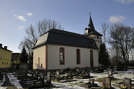
Village church of St. Salvator
|
|
Scherndorf is a district of the town of Weißensee in the Sömmerda district in Thuringia .
geography
The district of Scherndorf is located east of Weißensee on Landesstrasse 2133 in the fertile arable area of the Thuringian Basin and near the Unstrut and its lowland.
history
The village was first mentioned on September 14, 1271. The village once belonged to the Comturei Griefstedt . In 1852 the peasants were given land for free ownership by lease . The place belonged to the Electoral Saxon Office Weißensee until 1815 . The decisions of the Congress of Vienna he came to Prussia and in 1816 the district Weissensee in the administrative district of Erfurt the province of Saxony assigned to which he belonged until 1944th
The church was probably built in the early 18th century.
Web links
Individual evidence
- ^ Wolfgang Kahl : First mention of Thuringian towns and villages. A manual. 5th, improved and considerably enlarged edition. Rockstuhl, Bad Langensalza 2010, ISBN 978-3-86777-202-0 , p. 248.
- ^ The district of Weißensee in the municipality register 1900 .
- ↑ Information about the location on the Weissensee website. ( Page no longer available , search in web archives ) Info: The link was automatically marked as defective. Please check the link according to the instructions and then remove this notice. Retrieved from the Internet on February 13, 2012.

