Dermsdorf
|
Dermsdorf
City of Kölleda
Coordinates: 51 ° 12 ′ 12 ″ N , 11 ° 11 ′ 54 ″ E
|
|
|---|---|
| Height : | 139 m above sea level NN |
| Incorporation : | January 22, 1994 |
| Postal code : | 99625 |
| Area code : | 03635 |
|
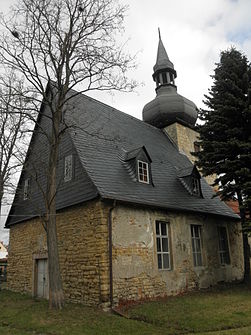
Church of Dermsdorf (2012)
|
|
Dermsdorf is a district of Kölleda in the Sömmerda district in Thuringia . The place is in the Thuringian Basin .
location
Dermsdorf is located about eight kilometers (as the crow flies) east of the district town of Sömmerda and about 4.5 kilometers from the city center of Kölleda. About 1.5 kilometers east of the outdoor pool is a lowland with the Streitsee - a natural body of water and at the same time the headwaters of the Monna stream , which flows close to the south around Dermsdorf.
history
Dermsdorf was incorporated into Kölleda on January 22, 1994 by the Thuringian Reorganization Act of August 27, 1993 . In 2011 there was the archaeologically important hoard from Dermsdorf .
Development of the population in Dermsdorf:
|
politics
District Mayor
On May 25, 2014 Carsten Stange (CDU) was elected mayor of the district.
Culture and sights
- On the southern outskirts of Dermsdorf is the Erfurt-Sömmerda airfield , a former military airfield of the Group of Soviet Armed Forces in Germany (GSSD). In the hangars there, you can see several types of decommissioned combat aircraft. The airfield is now used as a commercial airfield and is used for the training of pilots and parachutists.
- In the center of the village is the listed village church of St. Johannes Baptist . The church is being renovated with the support of the German Foundation for Monument Protection (DSD). So far (2010) it has received a new slate roof.
- South of the village on the Monna brook, you will find the Durholdsche Mühle.
Individual evidence
- ↑ Source: Thuringian State Office for Statistics, accessed on October 11, 2018
- ^ History. In: www.flugservice-soemmerda.de online magazine. Retrieved May 28, 2010 .

