
Noda
| coat of arms | Germany map | |
|---|---|---|

|
Coordinates: 51 ° 4 ′ N , 11 ° 1 ′ E |
|
| Basic data | ||
| State : | Thuringia | |
| County : | Sömmerda | |
| Management Community : | Gramme-Vippach | |
| Height : | 170 m above sea level NHN | |
| Area : | 6.44 km 2 | |
| Residents: | 805 (Dec. 31, 2019) | |
| Population density : | 125 inhabitants per km 2 | |
| Postal code : | 99195 | |
| Area code : | 036204 | |
| License plate : | SÖM | |
| Community key : | 16 0 68 037 | |
| Association administration address: | Erfurter Str. 6 99195 Schloßvippach |
|
| Website : | ||
| Mayor : | Stefan Berth ( CDU ) | |
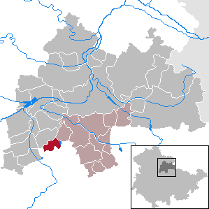
| Location of the municipality of Nöda in the district of Sömmerda | ||
  |
||

Nöda is a municipality in the Sömmerda district in Thuringia . It belongs to the administrative community Gramme-Vippach , which has its administrative seat in the municipality of Schloßvippach .

geography
Nöda is located in the south-eastern part of the Thuringian Basin . At 192 m, the Nödaer Warthe is the highest point in the village. The community has a total area of 640 hectares, of which about 80 hectares are water surface, which was mainly created by gravel mining. The municipalities of Riethnordhausen , Alperstedt and the state capital Erfurt border on Nöda .
history
In 1308 the first documentary mention was made in the church book of " Sankt Severin " in Erfurt . Around 1500, today's Protestant St. Mary's Church was built in the late Gothic style. Until 1815 the place belonged as an exclave to the administrative office of Weißensee . Through the resolutions of the Congress of Vienna he came to the Grand Duchy of Saxony-Weimar-Eisenach and was assigned to the office of Großrudestedt in 1816. With the dissolution of the office, the place came to the Weimar administrative district in 1850 , to which it belonged until 1920.
At the beginning of the Nazi era, a street battle between SA men and communists took place in Nöda , in which one person was injured. As part of the “ euthanasia ” murder program of Operation T4 , four residents were killed. During the Second World War , 51 women and men from Poland , Russia , Yugoslavia and Italy had to do forced labor in agriculture.
Population development
Development of the population:
- 1994-601
- 1995-632
- 1996- 729
- 1997-811
- 1998 - 817
- 1999-857
- 2000-869
- 2001 - 845
- 2002 - 837
- 2003 - 841
- 2004 - 848
- 2005 - 841
- 2006 - 831
- 2007 - 842
- 2008 - 851
- 2009 - 834
- 2010 - 821
- 2011 - 828
- 2012 - 820
- 2013 - 817
- 2014 - 827
- 2015 - 834
- 2016 - 823
- 2017 - 830
- 2018 - 815
Data source: Thuringian State Office for Statistics
politics
Municipal council
The local council from Nöda consists of five members of the CDU and 3 members of the Nöda electoral community (status: local election on May 25, 2014).
mayor
Stefan Berth currently holds the office of mayor.
Sports
Alperstedter See (approx. 66 hectares of water) is located in the municipality of Nöda . A water sports center was built adjacent to this, which offers a variety of opportunities for recreational activities and relaxation.
Individual evidence
- ^ Population of the municipalities from the Thuringian State Office for Statistics ( help on this ).
- ↑ Geographical overview of the Saxon-Ernestine, Schwarzburg, Reussian and adjacent lands. Perthes, Gotha 1826, p. 54 .
- ^ The administrative district of Weimar in the municipal directory 1900 .
- ↑ Gudrun Braune: Memories of the time between 1930 and 1947 (= sources on the history of Thuringia. (1)). State Center for Political Education Thuringia, Erfurt 1996, ISBN 3-931426-10-6 , p. 30.
- ↑ Thuringian Association of the Persecuted of the Nazi Regime - Association of Antifascists and Study Group of German Resistance 1933–1945 (Ed.): Local history guide to sites of resistance and persecution 1933–1945. Volume 8: Thuringia. VAS - Verlag für Akademische Schriften, Frankfurt am Main 2003, ISBN 3-88864-343-0 , p. 280.
Web links
Alperstedt | Andisleben | Büchel | Buttstädt | Eckstedt | Elxleben | Gangloffsommern | Gebesee | Griefstedt | Großmölsen | Großneuhausen | Großrudestedt | Favored | Hatred life | Kindelbrück | Kleinmölsen | Kleinneuhausen | Kölleda | Markvippach | Nöda | Ollendorf | Eastern amondra | Rastenberg | Riethgen | Riethnordhausen | Ring life | Castle Vippach | Schwerstedt | Sömmerda | Sprötau | Straussfurt | Udestedt | Vogelsberg | Whale life | Weissensee | Werningshausen | Witterda | Miraculous life