
Udestedt
| coat of arms | Germany map | |
|---|---|---|

|
Coordinates: 51 ° 3 ' N , 11 ° 8' E |
|
| Basic data | ||
| State : | Thuringia | |
| County : | Sömmerda | |
| Management Community : | Gramme-Vippach | |
| Height : | 174 m above sea level NHN | |
| Area : | 16.32 km 2 | |
| Residents: | 774 (Dec. 31, 2019) | |
| Population density : | 47 inhabitants per km 2 | |
| Postal code : | 99198 | |
| Area code : | 036203 | |
| License plate : | SÖM | |
| Community key : | 16 0 68 055 | |
| Association administration address: | Erfurter Str. 6 99195 Schloßvippach |
|
| Mayor : | Gunnar Dieling | |
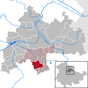
| Location of the municipality of Udestedt in the district of Sömmerda | ||
  |
||

Udestedt is a municipality in the Sömmerda district in Thuringia . It belongs to the administrative community Gramme-Vippach , which has its administrative seat in the municipality of Schloßvippach .
geography
Udestedt is located in the south-eastern part of the Thuringian Basin . The small river Gramme runs east of the village to the north . Udestedt is surrounded by several 200 m high hills.
Village complex
Udestedt is an irregularly laid out street village with several forks in the road, which originally extended to a valley basin. A derivation from the Gramme, the Mühlgraben, was laid as a water supply . It begins south of the village upstream and later returns its water to the Gramme. To the north of the village are very extensive, modernized cattle stables.
history
The area around Udestedt is ancient settlement soil. There were graves of the Neolithic ceramists from the 3rd millennium BC, burials from the Bronze Age around 1000 BC and from the Celtic , then Germanic times from 500 BC to 400 AD. In the 3rd and 4th centuries there was one Settlement east of the current location around Table Mountain. The name of the place Udestedt is derived from a Germanic cult site "Odinstatt" located on the Gramme . In 876 "Odestat" (Latin) was mentioned for the first time in a document as a village subject to the monastery of Fulda . Around 1000 a small castle in the form of a high moth was built in the area of Table Mountain. There were gentlemen from "Utstete". In the High Middle Ages, another settlement center formed, the upper village, with a market settlement along the artificial mill moat. A new, walled castle was built on the southwestern edge of this settlement, which was destroyed in the War of Succession in 1309 and then rebuilt (today only the remains of the moat in the estate area). In 1219 a "Knight of Rudestedt", namely Friedrich von Rudestedt, was named for the first time. Various nobles, churches and monasteries owned properties in Udestedt. In 1345 the city of Erfurt bought the village for 500 marks from "Rudolf von Mellingen".
In the 14th century, the inhabitants of the Barkhausen monastery courtyard to the west of Udestedt and belonging to the Georgenthal monastery gave up the place, which became a desert , and moved to Udestedt. The stones from the buildings were used to build new houses and the Udestedt Church. An interest group from Udestedter citizens, the "trade union", acquired most of the Barkhaus corridor from the Georgenthal monastery. On the surface, only a simple, 6 m high and 4 m thick medieval tower remains of Barkhausen, the so-called Barkhausen Tower . The foundations of the Barkhaus buildings were largely destroyed by agricultural use, and the cellar vaults collapsed when heavy equipment was driven on between 1950 and 1970.
For centuries, the cultivation of the dye plant woad played an important role in Udestedt, and many farmers from the village were recorded in the Erfurt woad register . At the time of the Reformation , the place became Protestant early on. In the Thirty Years' War Udestedt suffered greatly. In 1623 it was plundered, devastated and harassed by 16 executions and deportations by mercenaries of Duke Friedrich von Altenburg after brave resistance from the residents . In 1624 250 buildings burned down. In 1664 Udestedt became Electoral Mainz together with Erfurt .
In 1802 Udestedt came with the Erfurt area to Prussia and between 1807 and 1813 to the French principality of Erfurt . With the Congress of Vienna in 1815 Udestedt came with the Amt Azmannsdorf to the Grand Duchy of Saxony-Weimar-Eisenach ( Amt Vieselbach ), to whose administrative district Weimar it belonged from 1850.
In 1759 there was another extensive fire in the village, which in 1819 was exceeded by the "Great Fire". This destroyed 100 houses and 150 farm buildings. Grand Duke Karl August and his Minister of State Goethe inspected Udestedt after the accident. Under the direction of the Weimar court architect Clemens Wenzeslaus Coudray , the extensive reconstruction was carried out with special attention to the prevention of further conflagrations. The grateful Udestedt named a street "Augustgasse".
In the revolutionary year of 1848 Udestedt also set up a vigilante group. In 1883 the Udestedt volunteer fire brigade was founded . The 19th century brought with it the emigration of a total of 120 Udestedtern overseas. The emigration of "problem people" was financially supported by the community, which was also common in other places. After the establishment of the German Empire in 1871, there was also a general economic boom in Udestedt. In 1913, the community celebrated the 100th anniversary of the victory over Napoleon in the Battle of the Nations near Leipzig and on this occasion inaugurated a war memorial ( Franco-German War 1870/71). After the First World War , a memorial plaque with the names of the 45 fallen from the community was embedded in the church wall.
During the Second World War , Udestedt had to take in families evacuated from the air war zones of the Reich and then hundreds of displaced persons from the eastern regions. The population increased from 855 in 1939 to 1,335 in 1946, despite the losses of 76 fallen and missing soldiers. During the Second World War , 81 women and men from Poland , Russia and Ukraine had to do forced labor in agriculture. A memorial stone in the cemetery commemorates two concentration camp prisoners who were victims of a death march to Buchenwald concentration camp in April 1945 . A local resident hoisted a white flag on April 11th and saved the village from being shot at. Udestedt was occupied by US troops in April 1945 and by the Red Army in early July . So it went along with all social changes in the Soviet Zone and later in the GDR . Particularly depressing for the farmers was the high delivery target , later the compulsion to join the LPG . Not a few escaped this by fleeing to West Germany. In 1985 Udestedt celebrated a 1111 year celebration, strictly speaking two years early.
In November 1989, as part of the Peaceful Revolution in the GDR, there were also devotions in the church in Udestedt - based on the model in Erfurt and Weimar - followed by political speeches in the open air and then demonstrations through the town, including a "round table" ". On October 3, 1990, the official day of German reunification was celebrated. Far-reaching, particularly economic changes followed. In 2000 the "Kreis-Heimattag" was celebrated in Udestedt.
Attractions
- The village has remained structurally intact in both world wars. Various historical farmsteads have been preserved, such as the manor house in front of the upper gate and the "Weimarischer Hof" restaurant. Even if a lot has been lost due to demolition and renovations, the large farm gates in particular give an idea of what a prosperous farming village Udestedt was before collectivization.
- The Protestant St. Kilian's Church (Udestedt) is a stately building that testifies to the former prosperity of the place. The tower has defensive features and was formerly free, it could have been part of a fortification. In 1575 a citizen of Erfurt donated a valuable wood carving "The Adoration of the Magi" to the church. The nave was rebuilt in 1592/94. In 1709 the church received an organ from the famous organ builder Georg Christoph Stertzing . In 1721 Tobias Friedrich Bach (1695–1768, son of Johann Christoph Bach from the famous family of musicians) became cantor and organist. In 1817, citizens of their church donated the painting "Luther at the Reichstag in Worms" by the Weimar painter Ferdinand Jagemann . In 1928 a new organ was installed.
- The churchyard still has a number of historical grave monuments.
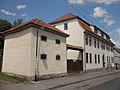
- The neighboring rectory (Schulplatz 7) has been renovated, the cantor's building (Schulplatz 5) and other outbuildings in the large rectory are in decay or demolished.
- Also nearby (Schulplatz 1) is the listed house of the cantor Tobias Friedrich Bach , who worked here from 1695 to 1768. Until 1868 the Kantoratshaus was Udestedt's schoolhouse. The building is currently not in use (2016) and only serves as a storage facility for the school caretaker.
- The current school building (Schulplatz 3) from 1869 in brick construction bears the motto for the students above the gate: "God bless your entrance and exit."
- Barkhäuser Tower of the former Barkhausen monastery courtyard from the late Middle Ages, west of the village
- Table Mountain on the south-eastern outskirts: cult site from the Germanic-pagan times
economy
From 1953 to 1960 (this year under increased pressure as "Socialist Spring") three LPGs were founded. Later, as part of the industrialization of agriculture, two large and successful cooperatives were formed. These played an important role for the village population, also through numerous social institutions. The plant production (KAP) cultivated feedstuffs and various foods typical of the region and operated poultry and sheep breeding on a small scale. The animal production could keep up to 4700 animals at the same time with the bull fattening and was thus one of the large fattening farms. Pig breeding was only carried out to meet the needs of the village population. Economically, the cooperatives worked with Kerspleben in particular , but also with other neighboring communities.
After the reunification, an "Agrargenossenschaft eG Udestedt" was founded in 1991. The number of 4,000 cops at the beginning could not be maintained, so and due to the rationalization, the number of employees decreased drastically. In 1993, a "reinstaller" (winegrower) started work on the 230 hectare estate.
traffic
Udestedt is on a country road between Eckstedt and Kleinmölsen . The federal highway 71 runs to the west from Erfurt to Sömmerda.
Good bike paths connect Udestedt with the neighboring towns, the Barkhäuser Tower and the Schwanseer Forest .

Church (2010)

Church (2016), view from Kirchgasse

Rectory

Rectory

school
Courtyard building

Monument from 1913
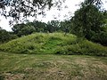
Table Mountain, Germanic place of worship
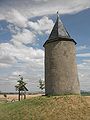
Barkhäuser tower


Population development
Development of the population:
|
|
|
|
|
|
Data sources: Thuringian State Office for Statistics and Ortschronik
politics
Municipal council
The local council from Udestedt consists of 8 councilors.
- Independent citizen list: 8 seats
(As of: local elections on May 25, 2014)
mayor
The honorary mayor has been Gunnar Dieling since July 1, 2016.
Personalities
- Tobias Friedrich Bach (1695–1768) from Ohrdruf , a nephew of Johann Sebastian Bach , worked from 1721 to 1768 as a cantor in Udestedt.
societies
- History Association Udestedt eV
- Bowling Club 1991
- Women's church choir 1994
- Schützenverein Udestedt eV 1994
- Riding and driving association 1998
- Sports club FSV Udestedt 1991 eV
- Traditions- & Kirmesverein eV
Trivia
- In the population of Udestedt there are several large families with the name Steinmann , which is otherwise less often represented in the German-speaking area. While it was originally assumed that this unusual accumulation did not go back to a common ancestry, it has meanwhile been proven that all bearers of this surname in the village are connected to a "Nikolaus Heinrich Steinmann" who married into the village on September 13, 1807 : either through direct descent or through marriage into the families of the namesake.
- In Udestedt, socialist street names were not renamed after reunification , but kept. The main street is called Wilhelm-Pieck- Strasse after the first and only President of the GDR.
- The parish archive of the Udestedt parish has an important collection of music (music manuscripts and prints) from the 17th and 18th centuries, which are now kept in the archive of the Liszt School of Music Weimar .
- In the 19th century, newlyweds moved with the wedding party from the village to Table Mountain with music. There was dancing and partying. In pagan times it was a sacred place where sacrifices were perhaps made especially to the Germanic goddess Freya .
literature
- Wolfgang Stolze: Village music culture in Thuringia and its special position in music history. In: Music and Church. Vol. 61, 1991, ISSN 0027-4771 , pp. 213-226.
- Wolfgang Stolze: Thuringian Adjuvantenmusik in Udestedt and its neighboring towns. In: Sömmerdaer Heimathefte. 12, 2000, ZDB -ID 1170131-6 , p. 21.
- Dagmar Blaha, F. Boblenz, Helga Brück, Th. Hildebrand, D. Walter, W. Zeth: Udestedt. 876-2001. Festschrift for the 1125th anniversary from May 18 to 27, 2001 (= Sömmerdaer Heimatheft. Sonderheft. 2, ZDB -ID 2419870-5 ). Udestedt community and community of local history of the Sömmerda district, Udestedt 2001.
- Steffen Voss : The music collection in the Udestedt parish archive. Studies on the music history of Thuringia in the 17th and 18th centuries (= writings on Central German music history. Vol. 10). Publishing house for music books Karl Dieter Wagner, Schneverdingen 2006, ISBN 978-3-88979-095-8 .
Individual evidence
- ^ Population of the municipalities from the Thuringian State Office for Statistics ( help on this ).
- ^ Locations of the administrative district Weimar in the municipality register 1900 .
- ↑ Thuringian Association of the Persecuted of the Nazi Regime - Association of Antifascists and Study Group of German Resistance 1933–1945 (Ed.): Local history guide to sites of resistance and persecution 1933–1945. Volume 8: Thuringia. VAS - Verlag für Akademische Schriften, Frankfurt am Main 2003, ISBN 3-88864-343-0 , p. 278.
- ↑ Michael Köhler: Thuringian castles and fortified prehistoric and early historical living spaces. 2nd, expanded and revised edition. Jenzig-Verlag Köhler, Jena 2003, ISBN 3-910141-56-0 , p. 286.
- ^ Thuringian State Office for Statistics: Elections in Thuringia. In: www.wahlen.thueringen.de. Retrieved June 22, 2016 .
- ↑ Official Gazette of VG Gramme-Aue No. 5/2013 of May 30, 2013, p. 24, (according to the article, the source for this is the church records of the Udestedt parish)
Web links
Alperstedt | Andisleben | Büchel | Buttstädt | Eckstedt | Elxleben | Gangloffsommern | Gebesee | Griefstedt | Großmölsen | Großneuhausen | Großrudestedt | Favored | Hatred life | Kindelbrück | Kleinmölsen | Kleinneuhausen | Kölleda | Markvippach | Nöda | Ollendorf | Eastern amondra | Rastenberg | Riethgen | Riethnordhausen | Ring life | Castle Vippach | Schwerstedt | Sömmerda | Sprötau | Straussfurt | Udestedt | Vogelsberg | Whale life | Weissensee | Werningshausen | Witterda | Miraculous life