
Ostramondra
| coat of arms | Germany map | |
|---|---|---|

|
Coordinates: 51 ° 12 ' N , 11 ° 20' E |
|
| Basic data | ||
| State : | Thuringia | |
| County : | Sömmerda | |
| Management Community : | Koelleda | |
| Height : | 187 m above sea level NHN | |
| Area : | 18.44 km 2 | |
| Residents: | 476 (Dec. 31, 2019) | |
| Population density : | 26 inhabitants per km 2 | |
| Postal code : | 99636 | |
| Area code : | 036378 | |
| License plate : | SÖM | |
| Community key : | 16 0 68 041 | |
| Association administration address: | Markt 1 99625 Kölleda |
|
| Website : | ||
| Mayor : | Axel Thomas (independent) | |
| Location of the municipality of Ostramondra in the district of Sömmerda | ||
  |
||

Ostramondra is a municipality in the Sömmerda district in Thuringia . It belongs to the administrative community Kölleda , which has its administrative headquarters in the city of Kölleda .
geography
Ostramondra is located on the southern edge of the Finn between Thuringian Gate and the northernmost wine-growing region Freyburg (Unstrut) . The district of Rettgenstedt belongs to Ostramondra . The Schafau brook runs through Ostramondra , into which the Litterbach flows from the north.
history
Ostramondra was first mentioned in 876. The place belonged to the county of Stolberg in fiefdom of the dukes of Saxony. The Counts of Stolberg enfeoffed Hans Knauth in 1461 with Ostramondra Castle including the manor, location and jurisdiction. The noble Knauth family owned Ostramondra until 1596/1612. It followed as the owner of the castle and manor which Tangels , 1708 Heinrich von Bünau , 1770 by Sperling , 1829 Schubert and last of Krosigk .
In April 1945 the US Army occupied the place. The castle was also occupied and Karl-Dedo von Krosigk and his sister Elisabeth were evacuated. After the Americans were replaced by the Soviet occupying power in early July 1945 , the Krosigks were expropriated without compensation.
The moated castle dates from the 18th century and was expanded after 1829. The manor covered 438 hectares and consists of very large and solid farm buildings. At the time of the GDR it housed a large sheep farm. In 2010 the buildings were largely empty. The castle has been restored and is privately owned with the park.
During the Second World War 245 prisoners of war as well as women and men from Russia , Poland , Ukraine , France and Italy had to do forced labor on the manor and with peasants.
Population development
Development of the population:
|
|
|
|
|
Data source: Thuringian State Office for Statistics
politics
Municipal council
The parish council from Ostramondra consists of 6 councilors and councilors.
- HV 1 seat
- FFW 2 seats
- Protect 1 seat
- Dance group 1 seat
- Sports club 1 seat
(As of: local election on May 26, 2019)
coat of arms
Blazon : "An overturned golden sword and a golden palm branch crossed diagonally in green , above a silver lily, below a silver flax blossom."
traffic
The federal highway 176 leads through the place. The Finnebahn Laucha – Kölleda railway to the north , which had a stop on the Ostramondra, is no longer in operation. Today the Finne hiking trail runs along the disused route.
Culture and sights
Buildings
- Ostramondra moated castle with park
- Evangelical Castle Church of St. Mary
- Farm building of the former manor
- Evangelical parish church St. Bonifacius in the district of Rettgenstedt
- Courtyard systems and portals
museum
- Home parlor
Monuments
- Tomb of the squire and Prussian major general Dedo von Krosigk (1856–1924) under a group of trees to the east of the estate park

Evangelical Church of St. Bonifatius in Rettgenstedt

Evangelical Castle Church of St Mary in Ostramondra
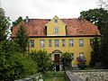
Ostramondra moated castle

Ostramondra Castle around 1860

Manor building in Ostramondra

Grave of the squire Dedo von Krosigk


Personalities
- Georg Friedrich Kauffmann (1679–1735), organist and composer of the Baroque
- Hans Rudolf von Bischoffwerder (1741–1803), advisor to Friedrich Wilhelm II of Prussia
- Johann Wilhelm Fuhrmann (1750–1780), Protestant theologian and professor at the University of Kiel
- Dedo von Krosigk (1856–1924), landlord, Prussian major general, legal knight of the Order of St. John
- Kurt Ritter (1909–1944), communist and resistance fighter
Individual evidence
- ^ Population of the municipalities from the Thuringian State Office for Statistics ( help on this ).
- ↑ Thuringian Association of the Persecuted of the Nazi Regime - Association of Antifascists and Study Group of German Resistance 1933–1945 (Ed.): Local history guide to sites of resistance and persecution 1933–1945. Volume 8: Thuringia. VAS - Verlag für Akademische Schriften, Frankfurt am Main 2003, ISBN 3-88864-343-0 , p. 272.
Web links
Alperstedt | Andisleben | Büchel | Buttstädt | Eckstedt | Elxleben | Gangloffsommern | Gebesee | Griefstedt | Großmölsen | Großneuhausen | Großrudestedt | Favored | Hatred life | Kindelbrück | Kleinmölsen | Kleinneuhausen | Kölleda | Markvippach | Nöda | Ollendorf | Eastern amondra | Rastenberg | Riethgen | Riethnordhausen | Ring life | Castle Vippach | Schwerstedt | Sömmerda | Sprötau | Straussfurt | Udestedt | Vogelsberg | Whale life | Weissensee | Werningshausen | Witterda | Miraculous life