
Whale life
| coat of arms | Germany map | |
|---|---|---|

|
Coordinates: 51 ° 4 ′ N , 10 ° 56 ′ E |
|
| Basic data | ||
| State : | Thuringia | |
| County : | Sömmerda | |
| Management Community : | Gera-Aue | |
| Height : | 160 m above sea level NHN | |
| Area : | 16.87 km 2 | |
| Residents: | 1825 (Dec. 31, 2019) | |
| Population density : | 108 inhabitants per km 2 | |
| Postal code : | 99189 | |
| Area code : | 036201 | |
| License plate : | SÖM | |
| Community key : | 16 0 68 057 | |
| Association administration address: | Marktplatz 13 99189 Gebesee |
|
| Website : | ||
| Mayor : | Marcel Bube ( SPD ) | |
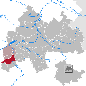
| Location of the municipality of Walschleben in the district of Sömmerda | ||
  |
||

Walschleben is a municipality in the Thuringian district of Sömmerda . It belongs to the administrative community Gera-Aue .
geography
Walschleben is nestled between the Gera and the Walschberg, about ten kilometers from the city center of the state capital Erfurt .


history
A monk Walo is said to have settled here around 300 AD . Walschleben was first mentioned in a document in 973. In 1322 the place was ravaged by the plague . In 1370 the Count von Gleichen sold the village to the city of Erfurt . At the end of the 15th century, a bailiwick of Walschleben with 16 villages, including Elxleben, Andisleben and Dachwig, is mentioned. At the time of the Reformation , the place became Protestant. After the Thirty Years War there were 44 of 305 houses in the village. In 1653 483 vineyards were counted, hemp , flax , anise and woad were grown. In 1683 there was another "great plague". Since 1706 the place belonged to the Erfurtischen Amt Gispersleben. In 1790 Walschleben had 800 inhabitants.
In 1802/03 Walschleben and the Erfurt area came to Prussia and between 1807 and 1813 to the French Principality of Erfurt . With the Congress of Vienna the place came back to Prussia and in 1816 it was incorporated into the Erfurt district in the Prussian province of Saxony . In 1869 the construction of the Erfurt-Nordhausen railway line began with the train station in Walschleben. In April 1945 American troops occupied the place, in July they were replaced by the Red Army . Walschleben was thus in the Soviet occupation zone (SBZ), and from 1949 in the GDR .
Population development
|
|
|
|
|
Data source: Thuringian State Office for Statistics
Attractions
The St. Crucis Church in Walschleben, built in 1495, is an important architectural monument. It is a unified hall church built in quarry stone with a polygonal closed choir and west tower. It was renewed in 1701. In 1888 the interior was redesigned and the northern stair tower was built.
In front of the church there is a war memorial for the fallen of both world wars.
Numerous historical farmsteads shape the townscape.
Economy and Infrastructure
There was a sugar factory in Walschleben from 1873 to 1990 . After a disaster on the sugar boiler (evaporative crystallizer) in November 1990, production at the plant, which was taken over from Südzucker AG after the fall of the Wall, was not restarted. As a result of the accident, the production plant was shut down. After the total demolition, the site was cleared and largely lay fallow until 2015. The areas are currently being used for the construction of the arterial road to Riethnorthausen. The old road was in need of renovation and will be located in the Gera floodplain in the future. This measure is part of a large-scale flood protection concept that affects numerous communities along the Gera.
education
Walschleben has a state primary school and a library . In the GDR, the school in Walschleben served as a polytechnic high school (POS) and was called " Hans Beimler ". It could be kept as a primary school and was renovated and expanded in 2004 and 2005 and equipped with a sports hall to accommodate the students from the surrounding communities. The primary school now bears the name of the Danish writer " Hans Christian Andersen ". Walschleben also has a very spacious kindergarten.
Transport links
Because it was part of the Erfurt-Land district and is close to the city, Walschleben has good transport links and is easy to reach. The Walschleben stop is on the Wolkramshausen – Erfurt railway line . Erfurt can be reached in 17 minutes with the Regional Express . In addition, the place is located directly on the federal highway 4 and via the federal highway 71 , the nearest junction is about six kilometers away, Walschleben has a direct connection to long-distance traffic. There is also a regular bus service between Erfurt and Walschleben and between Walschleben and Sömmerda .
In August 2013 the very unsightly station building was demolished on behalf of the owner Deutsche Bahn , for which no buyer could be found. The breakpoint remains.
The Gera cycle path runs east of Walschleben .
Personalities
Sons and Daughters of the Church:
- Johannes Baron von Watteville (1718–1788), Moravian missionary
- Arthur Böttner (1887–1947), internist
- Klaus Taubert (1940–2019), journalist and author
- Daniel Bärwolf (* 1973), soccer player and coach
Others
Polish slave laborers were used in Walschleben during the Second World War . The exact number is not yet known.
Individual evidence
- ^ Population of the municipalities from the Thuringian State Office for Statistics ( help on this ).
- ↑ Jakob Dominikus: Erfurt and the Erfurt area. According to geographical, physical, statistical, political and historical conditions. An award typeface co-crowned by the Academy of Useful Sciences in Erfurt. Part 2. Carl Wilhelm Ettinger, Gotha 1793, p. 15 .
- ↑ Stephanie Eißing and others: Thuringia (= Handbook of German Art Monuments . ). Revision. 2nd, revised and supplemented edition. Deutscher Kunstverlag, Munich 2003, ISBN 3-422-03095-6 , p. 1281 .
- ↑ Katrin Müller: The train station in Walschleben is being demolished. In: Thüringische Landeszeitung , August 9, 2013.
- ↑ Thuringian Association of the Persecuted of the Nazi Regime - Association of Antifascists and Study Group of German Resistance 1933–1945 (Ed.): Local history guide to sites of resistance and persecution 1933–1945. Thuringia . tape 8 . VAS - Publishing House for Academic Writings, Frankfurt am Main 2003, ISBN 3-88864-343-0 , p. 280 .
Web links
Alperstedt | Andisleben | Büchel | Buttstädt | Eckstedt | Elxleben | Gangloffsommern | Gebesee | Griefstedt | Großmölsen | Großneuhausen | Großrudestedt | Favored | Hatred life | Kindelbrück | Kleinmölsen | Kleinneuhausen | Kölleda | Markvippach | Nöda | Ollendorf | Eastern amondra | Rastenberg | Riethgen | Riethnordhausen | Ring life | Castle Vippach | Schwerstedt | Sömmerda | Sprötau | Straussfurt | Udestedt | Vogelsberg | Whale life | Weissensee | Werningshausen | Witterda | Miraculous life