
District of Greiz
| coat of arms | Germany map |
|---|---|

|

Coordinates: 50 ° 45 ' N , 12 ° 4' E |
| Basic data | |
| State : | Thuringia |
| Administrative headquarters : | Greiz |
| Area : | 845.97 km 2 |
| Residents: | 97,398 (Dec. 31, 2019) |
| Population density : | 115 inhabitants per km 2 |
| License plate : | GRZ, ZR |
| Circle key : | 16 0 76 |
| NUTS : | DEG0L |
| Circle structure: | 45 parishes |
| Address of the district administration: |
Dr.-Rathenau-Platz 11 07973 Greiz |
| Website : | |
| District Administrator : | Martina Schweinsburg ( CDU ) |
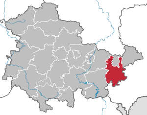
| Location of the district of Greiz in Thuringia | |
  |
|

The district of Greiz is a district in the east of the Free State of Thuringia with the district town of Greiz . In terms of spatial planning , the district belongs to the Eastern Thuringia planning region and is a member of the Eastern Thuringia planning community .
geography
Neighboring districts in the north are the Burgenlandkreis , which belongs to Saxony-Anhalt, and the independent city of Gera , in the northeast the district Altenburger Land , in the east the Saxon district Zwickau , in the south the Saxon Vogtlandkreis and in the west the Saale-Orla-Kreis and the Saale- Holzland circle . The south of the district belongs to the Thuringian Slate Mountains , while the north slopes down to the Leipzig lowland bay (Saale-Elster sandstone slab). The most important rivers are the White Elster , which flows in the east of the district, and its left tributary Weida , which is dammed up several times to form drinking water reservoirs. 213 km² of the district are covered with forest, 13.3 km² are water surfaces. The highest point is at 535.5 m above sea level. HNH the Allrichberg near Bernsgrün.
history
Historically, the district is part of the Vogtland and consists of four former principalities. There has been a district of Greiz continuously since the state of Thuringia was founded in 1920 (see also district of Greiz (1922–1952) ). In its present form, the district was created on July 1, 1994 by merging the districts of Gera , Zeulenroda and Greiz . Until March 31, 1992, the town of Elsterberg , the municipality of Görschnitz and until July 31, 1994 the municipality of Cunsdorf belonged to the old district of Greiz . They fell to Saxony through a referendum , to which they had also belonged until 1952.
Population development
Development of the population:
|
|
|
|
|
- Data source: from 1994 Thuringian State Office for Statistics - values from December 31st
politics
District Administrator
Martina Schweinsburg (CDU) has been the district administrator of the district since it was formed in 1994 . Before that, she was district administrator for the Zeulenroda district .
In the elections in April 2018 , Schweinsburg was confirmed in office for a further six years, after having achieved an absolute majority with 65.9 percent of the votes in the first ballot.
District council
The 46 seats in the district council have been distributed among the individual parties as follows since the local elections on May 26, 2019 :
| Political party | Seats | |
| CDU | 17 (-3) | |
| AfD | 9 (+9) | |
| The left | 5 (-4) | |
| SPD | 4 (–2) | |
| IWA | 4 (+1) | |
| Per municipality - FWG | 2 (± 0) | |
| Green | 2 (+1) | |
| FDP | 2 (+1) | |
| BIZ | 1 (-1) | |
| NPD | 0 (–2) |
The abbreviation IWA stands for Interest Group for Business and Work e. V. , BIZ stands for citizens' initiative for socially acceptable taxes and fair performance in Zeulenroda and the surrounding area .
coat of arms
Blazon : "Above a black-and-gold divided shield base covered with a curved, diagonal green diamond wreath, divided by black and silver, it shows an upright golden, red-crowned and armored lion at the front and a golden crane at the back."
The golden lion and the crane were derived from the coats of arms of the princes of Reuss , who owned most of this area for many centuries. A small part of the district belonged to the Duchy of Saxony-Weimar-Eisenach . Consequently, the simplified form of the Saxon coat of arms can be seen in the underside of the coat of arms.
An overview of the coats of arms of the towns and communities in the district can be found in the list of coats of arms in the district of Greiz .
economy

Around 8,000 companies - mainly in the small and medium-sized sector - are based in the district of Greiz. Important branches in manufacturing are the chemical industry, especially rubber and plastic goods, the textile industry, the food and luxury goods industry, wood processing and the metal processing industry. The Köstritzer Schwarzbierbrauerei and the Chemiewerk Bad Köstritz , the Bauerfeind Group ( Zeulenroda-Triebes ), the Breckle Matratzenwerk Weida GmbH ( Weida ) and the Wismut GmbH are among the major employers in the district. An area of around 520 km² is used for agriculture. The gross domestic product in 2007 was 1,864 million euros. Together with the city of Gera, the district of Greiz is responsible for the Sparkasse Gera-Greiz .
In the future atlas 2016 , the district of Greiz was ranked 349 out of 402 districts and independent cities in Germany, making it one of the regions with “high future risks”.
traffic
Road traffic
The district of Greiz is crossed by the federal highways 4 (Dreieck Kirchheim / A 7 - Eisenach - Gera - Dresden - Görlitz - border crossing PL) and 9 ( Berlin - Leipzig - Nuremberg - Munich ). In addition, the federal motorway 72 ( Hof - Chemnitz ) runs not far .
Other important roads are the federal highways, which run largely parallel to the A 9 in a north-south direction
- 2 ( Berlin - Leipzig - Gera - Schleiz - Nuremberg - Munich ) and
- 92 (Gera - Greiz - Plauen - border crossing CZ).
The federal highways run in an east-west direction
- 7 (border crossing NL - Düsseldorf - Kassel - Eisenach - Erfurt - Jena - Gera - Altenburg - Rochlitz ),
- 175 ( Harth-Pöllnitz - Weida - Zwickau - Nossen ) and
- 94 ( Schleiz - Zeulenroda - Greiz - Reichenbach - Rodewisch ).
Public transport
The local public transport (ÖPNV) is largely provided by the Verkehrsgemeinschaft des Landkreis Greiz . This includes four companies, two of which are in municipal hands: Personen- und Reiseverkehrsgesellschaft Greiz mbH (PRG) and RVG Regionalverkehr Gera / Land GmbH, which are merged under the umbrella of the Greiz Service and Management Company (SVG GRZ). The companies "Omnibusbetrieb Dipl.-Ing. (FH) Günter Herzum" and "Omnibusbetrieb Hartmut Piehler" also operate regular services in the north-eastern district.
Rail transport
Several railway lines, including the Central-Germany connection , complement the district's infrastructure. While the Werdau – Weida – Mehltheuer railway is still partially used, the Neumark – Greiz and Zeulenroda and Bf - Zeulenroda ob Bf lines are completely closed.
air traffic
Leipzig-Altenburg Airport is located in the neighboring district of Altenburger Land . The Gera-Leumnitz airfield is located in the city of Gera .
Waterways
There are no rivers that can be used to transport goods.
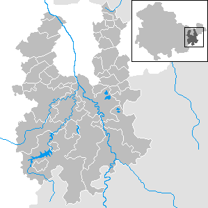
Communities
Greiz and Zeulenroda-Triebes are designated as medium-sized centers according to the regional plan.
The basic centers are the cities of Auma-Weidatal , Berga / Elster , Münchenbernsdorf , Ronneburg , Weida as well as, functional and cross-district, Bad Köstritz / Crossen an der Elster .
(Residents on December 31, 2019)
|
community-free municipalities
|
|
  |
Administrative communities
* Seat of the administrative community
|
|
|
For the terms "administrative community" and "fulfilling community" see administrative community and fulfilling community (Thuringia) .
Protected areas
There are five designated nature reserves in the district (as of January 2017).
Territorial changes
Communities
- Dissolution of the municipality of Neumühle / Elster - incorporation into the city of Greiz (December 31, 2019)
- Dissolution of the communities Hohenölsen , Steinsdorf and Schömberg - incorporation into the city of Weida (December 31, 2013)
- Dissolution of the communities of Hain , Lunzig , Neugernsdorf and Wildenaube - incorporation into Langenwetzendorf (December 31, 2013)
- Dissolution of the unitary community Vogtländisches Oberland - incorporation of the districts of Cossengrün , Hohndorf , Schönbach and the Eubenberg area (district of Arnsgrün) into the city of Greiz and the districts of Arnsgrün (without Eubenberg), Bernsgrün and Pöllwitz into the city of Zeulenroda-Triebes (December 31, 2012)
- Dissolution of the municipalities of Mohlsdorf and Teichwolframsdorf - merger to form the new municipality of Mohlsdorf-Teichwolframsdorf (January 1, 2012)
- Dissolution of the city of Auma and the communities of Braunsdorf , Göhren-Döhlen , Staitz and Wiebelsdorf - merger to form the new city of Auma-Weidatal (December 1, 2011)
- Dissolution of the municipalities of Merkendorf , Silberfeld and Zadelsdorf - incorporation into the city of Zeulenroda-Triebes (December 1, 2011)
- Dissolution of the city of Triebes - incorporation into the city of Zeulenroda , which is renamed Zeulenroda-Triebes (February 1, 2006)
- Dissolution of the municipalities of Arnsgrün , Bernsgrün , Cossengrün , Hohndorf , Pöllwitz and Schönbach - merger to form the new municipality of the Vogtländisches Oberland (July 1, 1999)
- Dissolution of the municipality of Dörtendorf - incorporation into the city of Triebes (April 1, 1999)
- Dissolution of the Friedmannsdorf community - incorporation into the Seelingstädt community (January 1, 1997)
- Dissolution of the communities of Kleinreinsdorf and Waltersdorf - integration into the community of Teichwolframsdorf (January 1, 1997)
- Dissolution of the community of Kraftsdorf, Niederndorf , Rüdersdorf and Töppeln - new formation of the community of Kraftsdorf (January 1, 1997)
- Dissolution of the communities of Daßlitz and Nitschareuth - incorporation into the community of Langenwetzendorf (January 1, 1996)
- Dissolution of the municipalities of Harth and Pöllnitz - merger to form the new municipality of Harth-Pöllnitz (December 21, 1995)
- Dissolution of the community of Mosen - incorporation into the community of Wünschendorf / Elster (September 2, 1995)
- Outsourcing of the Cunsdorf district from Schönbach to Saxony (August 1, 1994)
Administrative communities and fulfilling community
- The city of Greiz is no longer a fulfilling municipality for Neumühle / Elster (December 31, 2019)
- Dissolution of the administrative community Leubatal - division into the city of Weida , the community Langenwetzendorf and the administrative community Wünschendorf / Elster , Langenwetzendorf becomes a fulfilling community for Hohenleuben and Kühdorf (December 31, 2013)
- The city of Berga / Elster is no longer a fulfilling municipality for Mohlsdorf and Teichwolframsdorf (January 1, 2012)
- Expansion of the administrative community Ländereck to include the municipality of Wünschendorf / Elster (January 1, 2012)
- Dissolution of the administrative community Auma-Weidatal - split between the cities of Auma-Weidatal and Zeulenroda-Triebes (December 1, 2011)
- The city of Berga / Elster becomes a fulfilling municipality for Mohlsdorf and Teichwolframsdorf (January 1st, 2008)
- The city of Triebes is no longer a fulfilling municipality for Weißendorf - The newly formed town of Zeulenroda-Triebes remains a fulfilling municipality for Langenwolschendorf and becomes a fulfilling municipality for Weißendorf (February 1, 2006)
- Dissolution of the administrative community Vogtland Oberland - formation of a new municipality Vogtland Oberland (July 1, 1999)
- The city of Triebes is no longer a fulfilling municipality for Dörtendorf (March 31, 1999)
- The city of Zeulenroda becomes a fulfilling municipality for Langenwolschendorf (January 1, 1997)
- The city of Bad Köstritz becomes a fulfilling municipality for Hartmannsdorf (March 15, 1996)
- Dissolution of the Erlbach-Stübnitzthal administrative community - new formation of the Kraftsdorf community , Bad Köstritz becomes a fulfilling community for Hartmannsdorf (March 14, 1996)
- Dissolution of the administrative communities Auma and Weidatal - new formation of the administrative community Auma-Weidatal (January 2, 1996)
- Dissolution of the administrative community Neumühle / Elster - distribution of the communities to the communities Langenwetzendorf and Teichwolframsdorf ; the city of Greiz becomes a fulfilling municipality for Neumühle / Elster (December 31, 1995)
- The city of Triebes becomes a fulfilling municipality for Dörtendorf (December 31, 1995)
- The city of Bad Köstritz becomes a fulfilling municipality for Caaschwitz (December 30, 1995)
- Dissolution of the administrative community Harth - Harth becomes part of the newly founded municipality Harth-Pöllnitz ; the city of Weida becomes a fulfilling parish for Crimla (December 20, 1995)
- Expansion of the administrative community in Münchenbernsdorf to include the municipality of Zedlitz (July 28, 1995)
- Extension of the administrative community Ländereck to include the communities of Endschütz and Kauern (July 1, 1995)
- Dissolution of the administrative community Triebes - Triebes becomes a fulfilling municipality for Weißendorf (March 30, 1995)
- Expansion of the administrative community of Upper Sprottetal to include the communities of Bethenhausen , Brahmenau , Hirschfeld , Korbußen , Pölzig and Schwaara (February 3, 1995)
- Extension of the administrative community Ländereck to include the municipality of Hilbersdorf (July 1, 1994)
Name changes
- from administrative community Ländereck to administrative community Wünschendorf / Elster (February 7, 2013)
- from Verwaltungsgemeinschaft Oberes Sprottetal to Verwaltungsgemeinschaft Am Brahmetal (February 3, 1995)


License Plate
At the beginning of 1991 the district received the distinctive sign GRZ . It is still issued today. From July 1, 1994 to January 31, 1995 the abbreviation ZR was distributed in the old district of Zeulenroda . It has been available again since November 24, 2012.
Until about the year 2000, vehicles from the sub-circles were given special identification numbers:
| area | Letters | numbers |
|---|---|---|
| Part of Greiz | A to Z | 1 to 999 |
| AA to ZZ | 1 to 99 | |
| Part circle Gera | AA to ZZ | 100 to 999 |
Others
The district of Greiz organized the Federal Horticultural Show 2007 with the cities of Ronneburg and Gera and the Central Horticultural Association . The exhibition grounds in the district of Greiz in particular have long been characterized by uranium mining ( SDAG Wismut ). The reclamation was the focus of the work on Buga terrain.
literature
- Manfred Reiser: The place names of the Greiz and Zeulenroda districts . Leipzig 1967.
Web links
Individual evidence
- ^ Population of the municipalities from the Thuringian State Office for Statistics ( help on this ).
- ^ Greiz district: Geographical location. (No longer available online.) Archived from the original on December 9, 2014 ; Retrieved December 7, 2014 .
- ↑ Elmar Otto: Territorial reform: "If two poor people get married, they don't get richer". In: Ostthüringer Zeitung. March 15, 2013, accessed March 15, 2013 .
- ↑ a b District election in Greiz 2019 In: wahlen.thueringen.de .
- ↑ Future Atlas 2016. (No longer available online.) Archived from the original on October 2, 2017 ; accessed on March 23, 2018 .
- ^ Regional plan East Thuringia of October 28, 2011 , accessed on October 16, 2016
- ^ Population of the municipalities from the Thuringian State Office for Statistics ( help on this ).
Cities : Eisenach | Erfurt | Gera | Jena | Suhl | Weimar
Districts : Altenburger Land | Eichsfeld | Gotha | Greiz | Hildburghausen | Ilm district | Kyffhäuserkreis | Nordhausen | Saale-Holzland district | Saale-Orla district | Saalfeld-Rudolstadt | Schmalkalden-Meiningen | Sömmerda | Sonneberg | Unstrut-Hainich Circle | Wartburg district | Weimar Country