
Elsterberg
| coat of arms | Germany map | |
|---|---|---|

|
Coordinates: 50 ° 37 ' N , 12 ° 10' E |
|
| Basic data | ||
| State : | Saxony | |
| County : | Vogtland district | |
| Height : | 290 m above sea level NHN | |
| Area : | 25.1 km 2 | |
| Residents: | 3925 (Dec. 31, 2019) | |
| Population density : | 156 inhabitants per km 2 | |
| Postal code : | 07985 | |
| Area code : | 036621 | |
| License plate : | V, AE, OVL, PL, RC | |
| Community key : | 14 5 23 100 | |
| LOCODE : | DE ETB | |
| City structure: | 8 districts | |
| Website : | ||
| Mayor : | Sandro Bauroth | |
| Location of the city of Elsterberg in the Vogtland district | ||
  |
||


_-_gelaufen_1903.jpg)
The town of Elsterberg is located in the Vogtland on the White Elster . On July 25, 1952, the city was moved from Saxony to Thuringia and the Gera district as part of the territorial reform of the GDR . By referendum on April 1, 1992, the reorganization to Saxony in the Vogtlandkreis took place .
geography
Geographical location
Elsterberg is located in a valley starting from Greiz, surrounded by dense forests. The valley continues from the district of Gippe to Steinicht , a nature reserve in the Elstertal in the direction of Plauen, to Rentzschmühle and to the Elstertal bridge on the Weißen Elster . The B 92 from Plauen to Greiz runs through the small town. Greiz is about 6 km and Plauen about 13 km away.
Neighboring communities
Adjacent cities and municipalities are the cities of Netzschkau , Limbach and Pöhl in the Vogtlandkreis and the city of Greiz in the Free State of Thuringia .
City structure
Districts of Elsterberg are the incorporated
- Coschütz with back table
- Kleingera with Reuth settlement and Pfannenstiel
- Losa with Wipplas
- Scholas
- Cunsdorf
- Gorschnitz
- Noßwitz
- Gippe outskirts
history
Origin and foundation of the city
Elsterberg was first mentioned in a document in 1198. This mention is based on authenticated information and a roll of parchment that was probably burned in 1840. It mentions a small knight's seat, the Altes Haus Elsterberg castle complex, which stood 38 meters above the Elster on the Weßnitz rock, belonged to the knight Rayer von Elsterberg and was called Elsterburg. The name of the city is derived from the name of the castle - after its location on the Elster.
Years later, the lords of Lobdeburg colonized the area and built a second castle before 1225, which was later called Elsterberg Castle . They had a church built below the castle and settled subjects brought in from Franconia and Thuringia .
A town was not originally planned, but when 36 surrounding villages parish to Elsterberg in the 13th century and trade there, market rights were introduced. Elsterberg first appeared as a town in a document in 1354. Until 1700 it was a typical country town in which it was only allowed to produce and trade for personal use and within a certain banned mile .
After the Reformation in 1519, Thomas Müntzer stayed several times in Elsterberg. After the Schmalkaldic War , Elsterberg passed from the Ernestines to the bailiffs of Plauen as part of the Plauen office in 1547 , until it finally fell to Electoral Saxony in 1569 .

Statue of the knight Rayer von Elsterberg in front of the town hall

Lobdaburg ruins in Elsterberg, postcard from 1895

Lithograph by Elsterberg with Vogtland Switzerland, postcard 1895
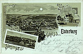
Moonlight lithograph by Elsterberg, postcard 1896

Lithograph by Elsterberg, postcard 1897
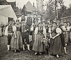
Elsterberg costumes 1897

_-_gelaufen_1899.jpg)
_-_gelaufen_1897.jpg)
_-_gelaufen_1896.jpg)
_-_gelaufen_1898.jpg)

City fires
Elsterberg was destroyed by three devastating city fires. In 1492 most of the city center was in flames and in 1702 the city center fell victim to the flames, except for the parish and the Frankenhof manor on the other side of the Elster. In 1840 the whole town with the church and town hall burned down. All town history files and documents - with the exception of the church registers (births, marriages, deaths) from 1658 - were irretrievably lost. It was only after the reconstruction in 1840 that today's cityscape emerged.
Industrialization into a staple fiber city
The first mechanical weaving mill opened in Elsterberg in 1882, and in 1908/09 the artificial silk factory was founded as "Sächsische Kunstseidenwerke AG", from which, after a few initial difficulties, the Elsterberg spinning fiber stock company was successfully established in 1919 , one of the most important relevant companies in Germany before the Second World War. The leather industry was also booming. In 1875 Elsterberg was connected to the railway network (between Gera and Plauen), which was very beneficial to the industrialization of the city.
Second World War
Except for a few duds, the small town of Elsterberg was spared from bombing raids during World War II. The occupation by American troops took place on April 16, 1945. In July of that year, the city was occupied by the Soviet military. Numerous resettlers who were expelled from Bohemia, Moravia and Silesia have found accommodation in the city since 1945. Supply bottlenecks made the situation complicated for all residents.
The time from 1945 to 1989
All Elsterberg companies were expropriated in 1946 and transferred to public property, industrial plants and large estates were in some cases forcibly confiscated. Many machines were dismantled from Yalta in accordance with the Allied Agreement and brought to the Soviet Union . Nevertheless, staple fiber production, like leather and stove manufacture, started up again with difficulties.
On July 25, 1952, the Saxon Elsterberg , which had previously belonged to the Plauen district , was incorporated into the new Gera district, Greiz district, as part of the administrative reform in the GDR and the associated repeal of the federal system .

In the years of the GDR, Elsterberg developed into an important industrial location in the Gera district. With the VEB Kunstseidenwerk Clara Zetkin , in which artificial silk and from the 1970s also viscose sponge cloths and sponges were produced, Elsterberg developed into a modern industrial city. Around 1,600 employees worked here, including numerous foreign contract workers in 1989 , including 66 Cubans and 125 Vietnamese. The companies in Elsterberg also included the VEB Linen Union, which primarily manufactured bed linen, the VEB Warming Device, in which the coveted Glutos ovens were manufactured, and the leather factory.
The period since 1989
.jpg)
The political change brought the collapse of the stove and leather industry in Elsterberg and the textile industry was not spared either. After 1990 only parts of staple fiber production survived. The production, which was brought up to date , only employed a fraction of the original workforce at Enka GmbH , but Elsterberger artificial silk continued to be in international demand. This remained so until 2009, despite full order books, the International Chemical Investors Group closed the Elsterberg site in favor of maintaining the plant in Obernburg , Bavaria , the only remaining glossy material plant next to the main administration in Wuppertal, and thus the last Elsterberg industrial company was lost. The city developed despite high unemployment. The old town was renovated, the forest pool was modernized, a bypass was built, historical building fabric was renewed with attention to detail, the castle cellar was redesigned and a lot was done in the incorporated districts.
On April 1, 1992, the city moved back to Saxony , together with 8 other Thuringian communities , to the Plauen district . The basis for this was the state treaty between the Free State of Saxony and the State of Thuringia on the change to the joint state border of February 11, 1992.
Incorporations
| Former parish | date | annotation |
|---|---|---|
| Coschütz | January 1, 1994 | |
| Cunsdorf | January 1, 1995 | |
| Kleingera | January 1, 1994 | |
| Losa | April 1, 1974 | Incorporation after Coschütz |
| Gippe | 1868 | |
| Gorschnitz | October 1, 1993 | |
| Field meadow | before 1880 | Incorporation after Coschütz |
| Noßwitz | May 1, 1972 | |
| Pan handle | before 1880 | Incorporation to Kleingera |
| Reuth | before 1880 | Incorporation to Kleingera |
| Rückisch | before 1880 | Incorporation after Coschütz |
| Scholas | 1st January 1979 | Incorporation after Coschütz |
| Thürnhof, manor district | April 1, 1921 | Incorporation after Coschütz |
| Wipplas | before 1880 | Incorporation to Losa |
Population development
In 1557 89 possessed citizens, 19 cottagers and 25 residents were counted, in 1748 there were 80 houses in the wall, 84 houses in the suburbs and 10 hooves per 30 bushels.
Population numbers and incorporations ( from 1998 December 31 ):
| year | 1834 | 1840 | 1895 | 1910 | 1960 | 1965 | 1971 | 1982 | 1990 | 1994 | 1998 | 2000 | 2002 | 2004 | 2006 | 2008 | 2010 | 2012 | 2013 | 2014 | 2015 | 2016 | 2017 | 2018 | 2019 |
| Residents | 2,320 | 2,081 | 4,814 a | 5,196 | 5,762 | 5,673 | 5,502 b | 5,156 | 4,766 | 5,735 c | 5,502 | 5,448 | 5,280 | 5,139 | 4,991 | 4,803 | 4,627 | 4,354 | 4.263 | 4,229 | 4,188 | 4.119 | 4,004 | 3,937 | 3,925 |

|
Sources: Elsterberg City Administration; from 1998: State Statistical Office of Saxony |
||||||||||||||||||||||||
politics
|
A total of 14 seats
|
City council
The incumbent city council was last elected on May 26, 2019 and is currently composed as follows:
| Party / list | Seats | + / - |
| AHL (alternative home list) | 9 | ± 0 |
| GfE (together for Elsterberg) | 4th | + 2 |
| SPD | 2 | ± 0 |
| AFL (General Fire Brigade List) | 1 | +1 |
| Ev. Parish | 0 | - 1 |
| The left | 0 | - 1 |
| CDU | 0 | - 1 |
mayor
| Mayor since 1887 | ||||
|---|---|---|---|---|
| 1887-1903 | Heinrich Haueisen | 1955-1960 | Albert Biering | |
| 1903-1922 | Emil Gebauer | 1960-1974 | Anton Landgrave | |
| 1922-1945 | Otto Lieske | 1974-1975 | Heinz Maier | |
| 1945-1947 | Otto Geiler | 1975-1986 | Gerhard Braun | |
| 1947-1950 | Walter Ritter | Oct./Nov. 1986 | Werner Fischer | |
| 1950-1954 | Paul Rudorian | Dec 1986-July 2015 | Volker Jenennchen | |
| 1954-1955 | Heinrich Fischer | since Aug. 1, 2015 | Sandro Bauroth | |
coat of arms
Blazon : “In blue a silver castle with two round towers; in between on the wall a magpie. ”The two-tower castle is depicted on a town seal from 1460. The current coat of arms has been used since 1896.
Culture and sights
Buildings


The landmark of the city, the ruins of the late Romanesque castle Elsterberg , is the largest ruined castle complex in Saxony with 1.5 hectares . Parts of the palas with the vaulted cellar and the wall with round towers have been preserved. The Laurentius Church and the town hall, built in neo-Gothic style, are also worth seeing.
Green spaces and recreation
From the Kriebelstein, enthroned 407 m above sea level, you can see Elsterberg and the surrounding area. The conservation area Steinicht, a river scenery, extends from the district Gippe of up Rentzschmühle at the Elstertalbrücke and is a popular hiking.
Sports


The Elsterberger Ballspielclub is the largest sports club in the city. The club was founded in 1912 from a merger of the clubs SC 1910 Elsterberg and Sportfreunde Elsterberg , and before 1945 played as a pure football club in the highest German Gauliga. Home is the Elsterberg Stadium , which was built in 1977 as the Red October Stadium .
In 1951 the association was reorganized as BSG Chemie Elsterberg . In addition to soccer, there were also swimming, chess and table tennis sections. In football, chemistry was a founding member of the Gera District League, founded in 1952 . In 1957, Chemie Elsterberg was promoted to the third-class GDR League II for one year. After relegation, Chemie Elsterberg merged with Progress Elsterberg to form the Elsterberg BSG unit .
Until 1990 unit shuttled between the Gera district league and district class. In 1990 the club started under the name SV Einheit first in Thuringia's district class, then after the referendum and incorporation of the city of Elsterberg from 1992 in Saxony and started again from 1996 under the historical name Elsterberger BC . After starting in the Chemnitz district league, the team slipped into the Vogtland district class area.
Economy and Infrastructure
.jpg)
traffic
Because the federal highway 92 runs through Elsterberg, the inner-city streets were heavily frequented. A bypass road already laid out before the Second World War was not continued during the GDR era. Only after 1990 was the road network renewed and expanded. At the turn of the millennium, the bypass road was completely put into operation and since 2010 a new road bridge south of the railway tunnel has been directing traffic coming from Plauen to this bypass road.
Local public transport is mainly covered by the Greiz passenger and travel company . Buses on line 1 run between Elsterberg and Greiz every half hour. This route was electrified from 1946 to 1969 and was used by a trolleybus . Line 2 connects the districts to the south and east. Line 84 of the Vogtland transport association runs every two hours to Reichenbach and the school bus line 401 to Plauen.
In addition, the Elstertalbahn runs through Elsterberg and connects the Thuringian Vogtland with Plauen and Gera. Until 2018, Elsterberg was also the end point of the RE 3 from Göttingen via Erfurt , Jena and Gera .
Personalities
Others

Due to the location on the border with Thuringia, there are some curiosities:
Together with the districts of Noßwitz, Görschnitz and Cunsdorf, the core city forms a part of Saxony that cannot be reached from the rest of the area by road or rail without crossing Thuringia. The usual (road) route from the districts of Kleingera and Coschütz to Elsterberg leads through the district of Sachswitz in the Thuringian city of Greiz . The federal road 92 runs twice on short sections through Thuringia between Elsterberg and the district town of Plauen : at the restaurant Zur Landes Grenz (to Hohndorf ) and in the area of the branches to Schönbach and Cossengrün .
The last houses on Sachswitzer Straße already belong to the Sachswitz district of the city of Greiz, but can only be reached from there via a dirt road.
A settlement belonging to the Kleingera district borders directly on the Dölau district of the city of Greiz. In the street between the sand pits , the plots on the northwest side belong to Dölau, those of the southeast to Kleingera.
literature
- Paul Reinhard Beierlein : History of the city and Elsterberg Castle i. V. Verlag Theo Krumm, four volumes, 1928–1934.
- Complete volume history of the city and castle Elsterberg i. V. 1934.
- Volume 1: Document book. 283 pages, 10 plates and 10 accompanying plates, 1928.
- Volume 2: History of the Church and School. 291 pages with 8 picture ax panels, 1929.
- Volume 3. History of the castle and the city. 503 pages, 14 plates and 14 picture plates, 1934.
- Dieter Scheffel: The city of Elsterberg in German history from 1871 to 1945. 2010. This volume continues the 3-volume chronicle by PR Beierlein. Two more volumes are published (1945 to the present).
- Paul Reinhard Beierlein: Historical hiking trips . No. 28 - Elsterberg and Vogtland Switzerland. Verlag Heinrich, Dresden, 1932.
- Heinz Mocker : Register, in alphabetical order by families, of the Elsterberg church books from 1638 to 1799. Copy of the manuscript. Plauen 1995. 2 volumes, 3682 families, according to the inventory, part IV of the German Central Office for Genealogy , p. 283
- Richard Steche : Elsterberg. In: Descriptive representation of the older architectural and art monuments of the Kingdom of Saxony. 11th booklet: Amtshauptmannschaft Plauen . CC Meinhold, Dresden 1888, p. 9.
Web links
- City of Elsterberg
- History of the industrialization of Elsterberg
- Elsterberg castle ruins - symbol of the city
- Elsterberg in the Digital Historical Directory of Saxony
Individual evidence
- ↑ Population of the Free State of Saxony by municipalities on December 31, 2019 ( help on this ).
- ^ Ernst Eichler and Hans Walther : Saxony. All city names and their history , Faber and Faber Verlag, Leipzig 2007, ISBN 978-3-86730-038-4 , p. 58
- ^ Paul Reinhard Beierlein: History of the city and Elsterberg Castle i. V. Verlag Theo Krumm, four volumes, 1928–1934
- ↑ Karlheinz Zierdt: The history of the city Elsterberg. In: Greizer Heimatbote. 1977.
- ↑ Siegfried R. Krebs, in: RotFuchs January 2015, extra supplement pp. III – IV
- ↑ (GrÄndStVtr SN / TH)
- ↑ a b c d State Statistical Office of the Free State of Saxony: Area changes
- ↑ a b c municipalities 1994 and their changes since 01.01.1948 in the new federal states , Metzler-Poeschel publishing house, Stuttgart, 1995, ISBN 3-8246-0321-7 , publisher: Federal Statistical Office
- ^ Gippe in the Digital Historical Directory of Saxony
- ↑ a b c d e The Saxony Book, Kommunal-Verlag Sachsen KG, Dresden, 1943
- ↑ Finance Ministerial Gazette for the Free State of Saxony, No. 8, 1921
- ↑ Digital historical place directory of Saxony. Retrieved September 14, 2012 .
- ↑ statistik.sachsen.de: Local election results 2019 - Elsterberg
- ^ Manfred Bensing, Karlheinz Blaschke, Karl Czok, Gerhard Kehrer, Heinz Machatscheck: Lexicon cities and coats of arms of the GDR . Ed .: Heinz Göschel. 2. rework. and exp. Edition. Bibliographisches Institut, Leipzig July 1984, p. 115 .
Adorf / Vogtl. | Auerbach / Vogtl. | Bad Brambach | Bad Elster | Mountains | Bösenbrunn | Eichigt | Ellefeld | Elsterberg | Falkenstein / Vogtl. | Grünbach | Heinsdorfergrund | Klingenthal | Lengenfeld | Limbach | Markneukirchen | Mill Valley | Hollow hammer | Netzschkau | Neuensalz | Neumark | Neustadt / Vogtl. | Oelsnitz / Vogtl. | Pausa-Mühltroff | Plauen | Pöhl | Reichenbach im Vogtland | Rodewisch | Rosenbach / Vogtl. | Schöneck / Vogtl. | Steinberg | Theuma | Tirpersdorf | Faithful | Triebel / Vogtl. | Weischlitz | Who's there
Coschütz | Cunsdorf | Elsterberg | Field meadow | Gippe | Görschnitz | Kleingera | Losa | Noßwitz | Pan handle | Reuth | Rückisch | Scholas | Thürnhof | Wipplas