
Obernburg am Main
| coat of arms | Germany map | |
|---|---|---|

|
Coordinates: 49 ° 50 ' N , 9 ° 8' E |
|
| Basic data | ||
| State : | Bavaria | |
| Administrative region : | Lower Franconia | |
| County : | Miltenberg | |
| Height : | 127 m above sea level NHN | |
| Area : | 24.83 km 2 | |
| Residents: | 8659 (Dec. 31, 2019) | |
| Population density : | 349 inhabitants per km 2 | |
| Postal code : | 63785 | |
| Area code : | 06022 | |
| License plate : | MIL, OBB | |
| Community key : | 09 6 76 145 | |
| LOCODE : | DE OBG | |
| City structure: | 2 districts | |
City administration address : |
Römerstrasse 62–64 63785 Obernburg |
|
| Website : | ||
| Mayor : | Dietmar Fieger ( CSU ) | |
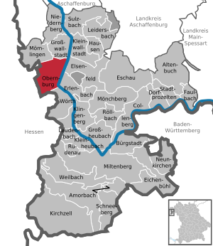
| Location of the city of Obernburg am Main in the Miltenberg district | ||
  |
||

Obernburg (officially: Obernburg a.Main , local : Omborsch ) is a town in the Lower Franconian district of Miltenberg and is located at the mouth of the Mümling , which is also called Mömling in the lower course, into the Main at the eastern foot of the Odenwald .
geography
terrain
Obernburg is bounded by two ridges in the south and north-west of the urban area. The southern ridge, the so-called "Obernburger Stadtwald" is used for forestry. In the direction of the Eisenbach district, the use - with the topography slowly becoming flatter - changes to agricultural land. The banks of the Mümling and the Main are mainly used as settlement areas. The north-western ridge is only partially forested. Agricultural use has established itself on this ridge.
The topographically highest point in the urban area is the so-called Querberg at 345 m above sea level. NN , the lowest is on the Main at 116.5 m above sea level. NN .
Location of the city
Obernburg is on the left side of the Main, at the confluence of the Mümling in the Main , roughly halfway between the district town of Miltenberg and the independent town of Aschaffenburg .
The city borders on the municipality of Großwallstadt in the north . In the south of the city is the city of Wörth a. Main . In the southwest and west, the Hessian communities in the eastern Odenwaldkreis - Lützelbach and Breuberg - border the municipality. The north-western neighboring community Mömlingen describes itself as "the gateway to the Odenwald". Above the Main, in the east, lies the Elsenfeld market and south of it the town of Erlenbach a. Main .
City structure
The political municipality of Obernburg has four officially named parts of the municipality in two districts.
- Obernburg (town and capital)
-
Eisenbach ( parish village )
- Lauterhof ( wasteland )
- Neustädterhof (wasteland)
The parts of the municipality are located in the districts of the formerly independent municipalities of Obernburg and Eisenbach.
Surname
etymology
The name Obernburg is composed of the Old High German words oboro , within the meaning of higher or further located above and burc for a fortified place . As an explanation, this results in a fortified place further up the valley (as Niedernburg, today Niedernberg ) .
Earlier spellings
Earlier spellings of the place from various historical maps and documents:
- 1183 Ouerenburch
- 1184 Obirinburc
- 1259 Oberenburg
- 1279 Obernburg
- 1964 Obernburg am Main
population
Population development

Obernburg's population was at the first official record, the census of December 1, 1840, at 2534 inhabitants. In the course of the 19th century, the number of inhabitants stagnated at this level - despite the city's status as a royal Bavarian district court . Only at the beginning of the 20th century did the population increase steadily. In 1900 the city had 2568 inhabitants, in 1925 it was 2992 and in 1939 there were already 3651 people in Obernburg. After the end of the Second World War , the population rose again. This happened in particular because war displaced persons were settled in Obernburg. The naming of two streets in what was then the new development area in Sudetenstrasse and Schlesierstrasse prove this increase in the number of inhabitants to 4899 inhabitants in 1950. The baby boom of the 1950s and 60s brought Obernburg a further increase in population, so that on May 27, 1970 - the last census before the incorporation of Eisenbach - 6124 people lived in Obernburg. At the next census in 1987, the combined population was 7,405.
The 2011 census found a population of 8,571. Since then, the city has only grown slightly to 8,647 inhabitants in 2016.
Religions
The population of the city of Obernburg is traditionally Christian . This is confirmed by the numbers on religious affiliation in 2011. There, of 8,571 inhabitants, 5,124 people or 59.8 percent of the population stated that they belong to the Catholic denomination and a further 1158 people, corresponding to 13.5 percent of the inhabitants, declared themselves to be part of the Evangelical Lutheran church community. It is worth mentioning, however, that the proportion of the Catholic population has decreased both in percentage and nominally and the proportion of Protestant Christians has increased in nominal terms. In 1987 there were still 5757 people (at that time corresponding to 77.7 percent of the population) members of the Catholic Church and only 992 (corresponding to 13.4 percent of the population) were members of the Protestant community.
Population structure
In the last census in 2011, Obernburger recorded a proportion of foreigners (population without German citizenship ) of 7.9 percent or 676 inhabitants. This corresponds with the national German average in the same year, which was also 7.9 percent of the population and was thus slightly below the Bavarian national average of 8.5 percent of the population.
Obernburg can boast a high purchasing power compared to its surroundings. The population of Obernburg has a purchasing power index that is around 15 index points higher than the two neighboring towns of Elsenfeld and Erlenbach, which are roughly the same size . The purchasing power of Obernburg is also higher than that of the entire district of Miltenberg and is even slightly higher than the purchasing power of the city of Aschaffenburg and is around the level of the state average in Bavaria.
history

Roman settlement
Around 107/110 AD the Romans built the Obernburg fort as an outpost and to secure the border of the Nassen Limes . In local parlance, the fortification was also called Nemaninga . The most important camp roads of the fort can still be seen today in the soft landscape of Obernburg's old town . The Roman troops stayed until around AD 260/275. Subsequently, Germanic tribes settled the place during the migration of peoples .
Middle Ages and elevation to the city
There are no records from the early Middle Ages, only from 1183 onward writings about the village of Ouerenburch appear again . In that year a certain pastor Heinrich donated revenues to Obernburg vineyards to the Aschaffenburg Abbey . In particular through a dispute between the Lords of Klingenberg and the Collegiatsstift Aschaffenburg, both of whom had large estates in Obernburg, in 1282 , the otherwise rather insignificant place found its way into history.
On March 25, 1313 Oberburg was the Mainz Archbishop Peter von Aspelt a town. The city charter was confirmed by King Ludwig of Bavaria on July 27, 1317 in a document issued in Aschaffenburg . The archbishop of Mainz raised the city to the rank of town because of tactical considerations in order to secure the holdings of the people of Kurmain on the Lower Main and to expand their power and wealth.
Obernburg comes to Bavaria
Up until the Reichsdeputationshauptschluss in 1803, Obernburg belonged to the Mainz Electorate , then to the newly founded Principality of Aschaffenburg , which became part of the Grand Duchy of Frankfurt in 1810 . In 1814 Obernburg became part of the Kingdom of Bavaria . In 1861 the city becomes the seat of the district office and the district court of Obernburg.
20th century
During the 1918 revolution , a workers 'and peasants' council was formed in Obernburg . Its chairman is the innkeeper Johann Elbert ( USPD ). From February to March 1919 a revolutionary action committee under Elbert's leadership took over power in the district office. Elbert's attempt to proclaim the Soviet republic in Obernburg in early April 1919 failed.
In 1939, the Bavarian districts were renamed Landkreis and the district offices were renamed Landratsamt. Obernburg was now the administrative seat of the district of the same name Obernburg . At the end of the Second World War Obernburg was occupied by American troops in 1945 and now belonged to the American zone of occupation . The Americans set up their military government for the district in Obernburg, with Captain BH Logan as chief.
The district of Obernburg was dissolved in the course of the regional reform in Bavaria on June 30, 1972 and went over to the newly formed district of Miltenberg .
Incorporations
On May 1, 1978, the previously independent community of Eisenbach was incorporated.
politics
European elections
In the 2019 European elections , the CSU won 37.71%, the SPD 10.61%, the Greens 20.48%, AfD 8.6% and other parties 22.59%. The turnout was 60.74%.
In the 2014 European elections , the CSU received 42.11%, the SPD 21.17%, The Greens 11.35%, AfD 7.95% and others 17.42%. The turnout was 40.64%.
City council
- The local elections on March 16, 2014 led to the following result:
Party / List: CSU SPD / Greens Active list Free voters total Seats: 9 4th 4th 3 20 seats Share of votes: 44.2% 22.1% 17.6% 16.1% 100%
- After a few changes of faction, the situation in Obernburg's city council (as of November 2018) is as follows:
fraction CSU SPD Active list Free voters total Seats: 8th 4th 4th 4th 20 seats Percentage 40% 20% 20% 20% 100%
- The local elections on March 15, 2020 resulted in the following distribution of seats in the city council:
Party / List: CSU Green SPD Active list Free voters total Seats: 7th 4th 1 3 5 20 seats Share of votes: 37.3% 18.6% 6.4% 13.6% 24.1 100%
Mayor of the city
|
|
Town twinning
Obernburg is twin town of Aszód in Hungary .
coat of arms
The first Obernburg coat of arms has been documented by the seal guide since 1465. In this the city still used the Mainz bike . In the course of joining the Kingdom of Bavaria, this connection with the former sovereigns had to be cut. That is why the city has had the current coat of arms since 1819.
The coat of arms shows a red stag in silver on a green shield base , carrying a golden grape with a green vine in its mouth. There is a cut green tree on the edge of the shield. The deer symbolizes the hunting license , the deciduous tree the forest and the vine branch the viticulture .
Economy and Infrastructure
economy
Agricultural and craft character
Up to the beginning of the 20th century, Obernburg's economy was mainly characterized by agriculture and craftsmanship. The red sandstone or red sandstone , which occurs around Obernburg , has been a sought-after raw material since Roman times . The Romans used it for the construction of fortifications or the production of consecration and gravestones, which is regularly documented by finds in Obernburg. However, the red sandstone and its beautiful color were also valued and dismantled after this time - for example when the Aschaffenburg Castle was built . The tradition of mining red sandstone lasted until the beginning of the 20th century, when this branch of industry was given up due to the use of modern building materials. However, sandstone houses can still be admired on a tour of Obernburg's old town. In addition, many of the typical vaulted cellars in Obernburg are clad with red sandstone.
Viticulture has played a major role in agriculture since the Middle Ages, but this eventually changed in favor of fruit growing. In the course of this, the Obernburg fruit processing cooperative (OVGO) was founded in 1890, which was to develop into an important center for fruit processing and the fruit trade on the Lower Main and shaped the entrance to the city for decades.
Late industrialization
With the establishment of Bayerische Glanzstoff-Fabrik AG in 1919 on the opposite bank of the Main, the city slowly industrialized. Today this industrial site bears the name Industrie Center Obernburg (ICO). Various types of man-made fibers are traditionally produced on the site. In addition, numerous small companies from various industries can be found at the location. These use the advantages of the location with the optimal transport connections to the Frankfurt economic area, which is secured by the historic industrial railway connection, the ship landing stage on the Main and the four-lane B469 motorway slip road . Although the industrial center bears the name Obernburg and this is also the place of the postal address, it is only located in the districts of the municipalities of Erlenbach am Main and Elsenfeld .
today
The only industrial area in Obernburg is located near the Eisenbach district in the south of the city and can be reached directly via federal highway 469 and federal highway 426. Diverse medium-sized industrial and service companies have settled there. The largest and internationally known company here is Reis Robotics, which was taken over by KUKA in 2014 .
Infrastructure
Federal highways
Obernburg is located with three junctions on the federal highway 469 . At the junction Obernburg-Süd the federal highway 426 begins , which crosses the northern Odenwald and ends in Gernsheim am Rhein.
railroad
The station Obernburg-Elsenfeld is located on the railway line Aschaffenburg-Miltenberg . It is given particular importance as a stop for the regional express. The Obernburg-Elsenfeld-Heimbuchenthal railway branched off here and has been closed since 1968.
Main bridges
The Main Bridge Obernburg / Elsenfeld ( Staatsstrasse 2308 ) for vehicles, bicycles and pedestrians and an additional pedestrian bridge (also approved for cyclists) span the Main and connect Obernburg with the Elsenfeld opposite .
Public facilities
Agencies and public authorities
For historical reasons there are a large number of offices and authorities in Obernburg.
- District court Obernburg
- Police station in Obernburg
- Branch of the employment agency
- Obernburg tax office with a branch in Amorbach
- Office of the District Office Miltenberg
- Vehicle registration office
The district court of Obernburg is the competent jurisdiction for the district of Miltenberg. The Obernburg police station is responsible for the former district of Obernburg, excluding Pflaumheim and Wenigumstadt - i.e. today's north of the district of Miltenberg. The employment agency also has a branch in the city. The Obernburg tax office with its Amorbach branch is the responsible tax office for the Miltenberg district. The Miltenberg district office also maintains an office in the former district town for historical reasons - which is why there is still a vehicle registration office in Obernburg. As the old district town, Obernburg used to be the seat of the Obernburg Regional Court .
Educational institutions
Obernburg also presents itself as an important location for educational institutions.
- Johannes Obernburger Primary School
- Middle School Obernburg a. Main
- Main-Limes-Realschule
- Vocational high school Obernburg - technical high school and vocational high school
- State vocational school Miltenberg-Obernburg
- Dr.-Albert-Liebmann-Schule - School for language training
- Music School Obernburg
The general education schools in Obernburg include the Johannes-Obernburger-Grundschule, the Mittelschule Obernburg a. Main and the Main-Limes Realschule . Vocational schools are the Miltenberg-Obernburg State Vocational School , the Vocational School for Commercial Assistants and the Obernburg Vocational School . Otherwise there is the Dr.-Albert-Liebmann - School for language training and a music school in Obernburg.
Other facilities
There are three day-care centers in Obernburg - the day-care center “Adventure House”, the day-care center “Altstadt” and the day-care center “Sonnenhügel”. In addition, there is a municipal library , two fire stations , two Catholic and one Evangelical Lutheran churches and two cemeteries in Obernburg .
tourism
Attractions


Obernburg's eventful history is visible through the remaining parts of the city fortifications . The looped fortifications and the preserved towers can be viewed on a circular route. What have been preserved - clockwise - are the Upper Gate, the Bag Tower, the Round Tower, the Hexenturm, the Lower Gate, the Gump Tower and the Almosenturm. The town hall in the center of the old town and the Anna chapel on the former Mühlbach are also worth seeing . An insider tip is the view from the Mittlere Höhenweg - popularly known as the " Franzosenweg" - of the old town and the central Main valley.
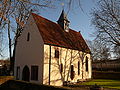
The Baroque church in the Eisenbach district is worth a detour.
The remains of the medieval Bacheburg are also close to the Neustädterhof .
Culture
Cabaret
In Obernburg is the nationally known cabaret Kochsmühle , where cabaret artists such as Urban Priol , Ottfried Fischer and Django Asül have performed.
Museums
The Römermuseum Obernburg is dedicated to the traces of Roman settlement in Obernburg and the surrounding area. The Eisenbacher Heimatmuseum is housed in the former new town hall of the district.
Regular events
- Since 1517, the Anna festival has been celebrated annually in Obernburg on the Sunday before or after St. Anna's Day (July 26th).
- Every year on the third weekend in July, the Mirabelle Festival is celebrated in the Eisenbach district.
- Since 1989 the Obernburger Mühlstein has been awarded regularly in Obernburg , a cabaret award for young cabarets.
- July: Obernburger Jazznight
Hiking trails
Bike trails
The following cycle paths lead through the urban area along the Main :
- The German Limes Cycle Route leads from Bad Hönningen through Westerwald , Taunus and Odenwald to Regensburg, 818 kilometers away, and is based on the historical course of the Upper German-Raetian Limes .
- The Main Cycle Path leads from the two sources of the Main along the river to its confluence with the Rhine near Mainz . It has a total length of about 600 kilometers.
- The D-Route D5 (Saar-Mosel-Main) . It leads over 1,021 kilometers from Saarbrücken via Trier, Koblenz, Mainz, Frankfurt am Main, Würzburg and Bayreuth to the Czech border.
- The 225 km long 3-country cycle path continues along the Mümling as a circular route through the triangle of Hesse, Baden-Württemberg and Bavaria. The route explores the Odenwald along the Mümling, Neckar and Main rivers. Part of this route is the 75-kilometer Mümling cycle path that connects Obernburg with Hirschhorn am Neckar .
- There have been two attractive mountain bike routes since 2012.
Hiking trails
- The Franconian Red Wine Trail has been leading through Obernburg's old town since 1990 .
- The European hiking trail E8 , which runs from Dursey Head in Ireland to Istanbul in Turkey , leads through Obernburg .
- Numerous signposted hiking trails also lead through the city forest.
Sports
There are a number of sports facilities in Obernburg. In the city of Obernburg these are the Valentin-Ballmann-Halle with the attached sports center at the elementary school. The tennis hall and courts on Salztrögweg, the bowling alley of the Salztrögstuben and the skate and course park at the Wendelinus chapel. In Eisenbach you will find the sports and culture hall, which is located in the immediate vicinity of the sports fields of TSV Olympia Eisenbach in Wiesentalstraße. There are also two shooting sports facilities in Obernburg - that of the Eisenbach shooting club and that of the Wilhelm Tell shooting club - and a riding facility at Neustädter Hof. Since 2006, on the Sunday after Ascension Day (May / June), the so-called “Roman Run” has been taking place in Obernburg with over 1000 participants.
Handball
The sports club Turn- und Sportgemeinde Obernburg 1879 e. V. (TUSPO) is best known for its handball department, whose first men's team played temporarily in the second Bundesliga.
Wrestling
In addition to TUSPO, some active members of the Stemm- und Ringclub Jugendkraft 1904 Obernburg (SRC Obernburg), which had existed since 1904, came to German and international championship titles.
Soccer
Originally two soccer teams competed for local supremacy in Obernburg - TSV Olympia from the Eisenbach district and the soccer department of TUSPO Obernburg. After the last men's team from TUSPO, football has only been played in Eisenbach since 2015. They are particularly proud of the successful regional youth work which resulted in a cooperation with Kickers Offenbach in 2016 .
Personalities
sons and daughters of the town

- Johannes Obernburger (around 1486 - 1552), chief secretary of the office of Emperor Charles V.
- Peter Obernburger (around 1530 - 1588) nephew of Johannes Obernburger, Imperial Court Secretary of Emperor Maximilian II , Imperial Court Councilor of Emperor Rudolf II.
- Adam Lux (1765–1793), revolutionary at the time of the French Revolution
- Johann Philipp Neumann, emigrated to Bohemia ( Prachatice ), father of St. Bishop Johann Nepomuk Neumann
- August Schnatz (1872–1973), master builder, honorary citizen of the city of Obernburg
- Josef Knecht (1897–1980), publisher
- Charlotte Marian (* 1937), pop singer
- Wolfgang Zöller (* 1942), Deputy Chairman of the CDU / CSU parliamentary group
- Thomas Aretz (* 1948), swimmer and Olympic participant
- Gitti and Erika (* 1958 and * 1956), singing duo
- Ulrich Eichhorn (* 1961), Car Manager and Head of Research and Development at Volkswagen AG
Other personalities
- Urban Priol (* 1961), cabaret artist
- Eva-Maria Grein von Friedl (* 1980), actress
- Sabine Englert (* 1981), professional handball player, national player
- Dominik Klein (* 1983), professional handball player, national player
Anna Chapel

Alms Tower

Round tower

City center


Oddities
The Obernburger were called town farmers by the rural environment . But they were also called handumme . As elsewhere a Johann Adam became a handam, so in the Obernburg dialect a Hans Thomas became a handumme. Johann Thomas used to be very often a naming in Upper Castle, the famous son of the city Johann Thomas Schmid, who is John Obernburger (1500-1552) called and as a doctor of law , private secretary Emperor Charles V was.
literature
- Ruth Weitz: Obernburg with long eyelashes. City-guide. Edition Fin Gadar, 2015, ISBN 978-3-945433-04-1 .
Web links
- Official website of the city of Obernburg am Main
- Entry on the coat of arms of Obernburg am Main in the database of the House of Bavarian History
References and comments
- ↑ "Data 2" sheet, Statistical Report A1200C 202041 Population of the municipalities, districts and administrative districts 1st quarter 2020 (population based on the 2011 census) ( help ).
- ↑ Obernburg dialect. Retrieved March 1, 2019 .
- ^ BayernAtlas. Retrieved November 9, 2018 .
- ^ BayernAtlas. Retrieved November 9, 2018 .
- ^ Bavarian State Library Online (BLO). In: www.bayerische-landesbibliothek-online.de. Retrieved December 13, 2016 .
- ↑ a b Wolf-Armin von Reitzenstein : Lexicon of Franconian place names. Origin and meaning . Upper Franconia, Middle Franconia, Lower Franconia. CH Beck, Munich 2009, ISBN 978-3-406-59131-0 , p. 169 ( limited preview in Google Book search).
- ↑ a b c d Statistics Obernburg a. Main. (PDF file) Bavarian State Office for Statistics, February 2018, accessed on December 28, 2018 .
- ↑ Bavarian parishes by predominantly Catholic or Protestant population. (No longer available online.) Bavarian State Office for Statistics, archived from the original on May 20, 2011 ; accessed on November 10, 2018 . Info: The archive link was inserted automatically and has not yet been checked. Please check the original and archive link according to the instructions and then remove this notice.
- ↑ Share of the foreign population in the total population in Germany from 1991 to 2017. Statista , accessed on November 10, 2018 .
- ↑ Share of the foreign population in the total population in Bavaria from 2002 to 2017. Statista, accessed on November 10, 2018 .
- ↑ Comparison of purchasing power in Obernburg. (PDF file) City of Obernburg, accessed on November 10, 2018 .
- ↑ Bernd Steidl: Limes World Heritage: Rome's border on the Main. Logo, Obernburg am Main 2008, ISBN 978-3-939462-06-4 , p. 109.
- ↑ That the name of the fort was Nemaninga is a speculation of local research. The assumption is based only on the fact that in the Obernburg area, in addition to the occupation of the cohort fort, a Numerus Brittonum Nemaningensium is suspected. The Nemaningensium refers to the Mömling brook but was probably misinterpreted as a fort name. Nothing is known about the actual ancient name of the fort.
- ↑ Egon Schallmayer: The Odenwald Limes. Along the Roman border between the Main and Neckar. Theiss, Stuttgart 2010, ISBN 978-3-8062-2309-5 , p. 70.
- ^ Johann Wilhelm Christian Steiner: History and topography of the old county and Cent Ostheim and the city of Obernburg am Main: 1 . Wailandt, 1821 ( google.de [accessed July 15, 2017]).
- ^ Johann Wilhelm Christian Steiner: History and topography of the old county and Cent Ostheim and the city of Obernburg am Main: 1 . Wailandt, 1821 ( google.de [accessed July 15, 2017]).
- ↑ Hubert Zöller: Church bells ringing for the Soviet Republic , in: Main-Echo , November 1, 2018 (accessed November 3, 2018)
- ↑ Christoph Weisz (ed.): OMGUS manual. The American military government in Germany 1945-1949 . Munich 1994. pp. 162-165. ISBN 3-486-55821-8 ( google.de , accessed November 3, 2018)
- ^ Federal Statistical Office (ed.): Historical municipality directory for the Federal Republic of Germany. Name, border and key number changes in municipalities, counties and administrative districts from May 27, 1970 to December 31, 1982 . W. Kohlhammer, Stuttgart / Mainz 1983, ISBN 3-17-003263-1 , p. 751 .
- ↑ European elections - European elections 2019 in the city of Obernburg a.Main - overall result. Retrieved June 3, 2019 .
- ↑ 2014 European elections. Accessed June 3, 2019 .
- ↑ 2014 European elections. Accessed June 3, 2019 .
- ↑ www.wahlen.bayern.de
- ↑ SessionNet | City council. Retrieved November 14, 2018 .
- ^ Stitch in the Greens and in the FW parliamentary group . In: main-echo.de . May 9, 2018 ( main-echo.de [accessed November 14, 2018]).
- ↑ Election of the Obernburg a.Main City Council 2020, overall result , accessed on June 14, 2020
- ↑ History | City of Obernburg. In: www.obernburg.de. Retrieved December 15, 2016 .
- ↑ Windows User: Obernburg Years. In: www.hvv-obernburg.de. Retrieved December 15, 2016 .
- ↑ Windows User: Obernburg Years. In: www.hvv-obernburg.de. Retrieved December 15, 2016 .
- ↑ History | City of Obernburg. In: www.obernburg.de. Retrieved December 15, 2016 .
- ^ House of Bavarian History - Bavaria's municipalities. Retrieved November 8, 2018 .
- ↑ hvv-obernburg.de
- ↑ Obernburg finds | Förderkreis Mainlimes-Museum eV Accessed on November 9, 2018 (German).
- ↑ Windows User: Buntsandstein component. Retrieved November 9, 2018 .
- ↑ Windows User: Obernburg Years. In: www.hvv-obernburg.de. Retrieved December 14, 2016 .
- ↑ Windows User: Obernburg Years. In: www.hvv-obernburg.de. Retrieved December 14, 2016 .
- ↑ Windows User: Obernburg Years. In: www.hvv-obernburg.de. Retrieved December 14, 2016 .
- ^ The ICO - Industrie Center Obernburg in the Rhine-Main area - Mainsite GmbH & Co.KG - Obernburg / Main. In: www.mainsite.de. Retrieved December 13, 2016 .
- ↑ KUKA Industries | KUKA AG. In: www.kuka.com. Retrieved December 13, 2016 .
- ^ Transport community on the Bavarian Lower Main. In: www.vab-info.de. Retrieved December 14, 2016 .
- ↑ Agencies & Authorities | City of Obernburg. In: www.obernburg.de. Retrieved December 15, 2016 .
- ^ Bavarian State Ministry of Justice: Justice in Bavaria - District Court Obernburg a. Main - home page. In: www.justiz.bayern.de. Retrieved December 15, 2016 .
- ↑ Bavarian Police - Police Inspection Obernburg a.Main. In: www.polizei.bayern.de. Retrieved December 15, 2016 .
- ↑ Employment Agency Obernburg - www.arbeitsagentur.de. In: www3.arbeitsagentur.de. Retrieved December 15, 2016 .
- ^ Obernburg tax office: About us - District. In: www.finanzamt.bayern.de. Retrieved December 15, 2016 .
- ↑ Miltenberg district - Directions / parking. In: www.landkreis-miltenberg.de. Retrieved December 15, 2016 .
- ^ Miltenberg district - vehicle registrations> vehicle registration office. In: www.landkreis-miltenberg.de. Retrieved December 15, 2016 .
- ↑ Home. In: www.vsobernburg.de. Retrieved December 15, 2016 .
- ^ Main-Limes-Realschule Obernburg. In: www.homepage.main-limes-realschule-obernburg.de. Retrieved December 15, 2016 .
- ↑ Home. In: www.fos-obernburg.de. Retrieved December 15, 2016 .
- ↑ Mil / Obb vocational school. In: www.bs-mil-obb.de. Retrieved December 15, 2016 .
- ↑ Home. In: www.liebmannschule.de. Retrieved December 15, 2016 .
- ↑ Musikschule Obernburg eV In: www.musikschule-obernburg.info. Retrieved December 15, 2016 .
- ↑ day care centers. In: www.obernburg.de. Retrieved December 15, 2016 .
- ↑ City library | City of Obernburg. In: www.obernburg.de. Retrieved December 15, 2016 .
- ↑ Fire departments | City of Obernburg. In: www.obernburg.de. Retrieved December 15, 2016 .
- ↑ Churches | City of Obernburg. In: www.obernburg.de. Retrieved December 15, 2016 .
- ↑ Windows User: City fortifications. In: www.hvv-obernburg.de. Retrieved December 15, 2016 .
- ↑ Anna Day | City of Obernburg. In: www.obernburg.de. Retrieved December 13, 2016 .
- ↑ Sports facilities. In: www.obernburg.de. Retrieved December 13, 2016 .
- ^ SG-Eisenbach. In: www.sg-eisenbach.de. Retrieved December 13, 2016 .
- ↑ Start. In: www.sg-obernburg.de. Retrieved December 13, 2016 .
- ↑ - Home. In: www.rufv-obernburg.de. Retrieved December 13, 2016 .
- ↑ www.roemerlauf.de - home page. In: www.roemerlauf.de. Retrieved December 15, 2016 .
- ↑ Stemm- und Ringclub Jugendkraft 1904 Obernburg eV (Obernburg), updated information, extracts from the commercial register - compaly. (No longer available online.) In: compaly.com. Archived from the original on December 13, 2016 ; accessed on December 13, 2016 . Info: The archive link was inserted automatically and has not yet been checked. Please check the original and archive link according to the instructions and then remove this notice.
- ^ Clubs / Offenbacher Kickers. In: www.kickersjugend.de. Retrieved December 13, 2016 .
- ^ Werner Trost: Stampes, Worzelköpp and Staffelbrunzer. Miltenberg district 2003.

Altenbuch | Amorbach | Bürgstadt | Collenberg | Dorfprozelten | Eichenbühl | Elsenfeld | Erlenbach am Main | Eschau | Faulbach | Großheubach | Großwallstadt | Hausen | Kirchzell | Kleinheubach | Kleinwallstadt | Klingenberg am Main | Laudenbach | Leidersbach | Miltenberg | Mömlingen | Mönchberg | Neunkirchen | Niedernberg | Obernburg am Main | Röllbach | Rüdenau | Schneeberg | Stadtprozelten | Sulzbach am Main | Weilbach | Wörth a.Main
Unregulated areas: forest forest | High maintenance