
3-country cycle route
| 3-country cycle route | |
|---|---|

|
|
| overall length | 225 km (circular route) |
| location |
|
| Places along the way | Michelstadt ( Bf ), Erbach ( Bf ), Beerfelden ( Bf ), Hirschhorn ( Bf ), Eberbach ( Bf ), Zwingenberg ( Bf ), Neckargerach ( Bf ), Mosbach ( Bf ), Limbach , Langenelz , Buchen ( Bf ), Walldürn ( Bf ), Amorbach ( Bf ), Miltenberg ( Bf ), Kleinheubach , Klingenberg ( Bf ), Wörth ( Bf ), Obernburg , Mömlingen , Breuberg , Höchst im Odenwald ( Bf ), Bad König ( Bf ) |
| Flooring | mostly paved |
| Height difference | approx. 110 m to approx. 470 m / approx. 1958 m ascent altitude profile |
| difficulty | approx. 42% easy, 55% medium, 3% difficult (according to ADFC classification) |
| Traffic volume | mostly car-free |
| Connection to | D-Route 4, Hessian long-distance cycle paths R4 , R9 , German Limes cycle path , Neckar valley cycle path |
| Website URL | radfahren.tg-odenwald.de |
The 225 km long 3-country cycle path leads through the triangle of Hesse, Baden-Württemberg and Bavaria. Along the Mümling , Neckar and Main, the route explores the Odenwald and passes numerous half-timbered historic cities, natural and cultural monuments as well as extensive forests. Since the tour also runs over inclines and steep slopes, which can only be partially avoided by rail, the route is only partially suitable for families. About 50% of the route is recommended by the ADFC for racing bikes.
Characteristic
The route is mostly flat along the rivers Main , Neckar and Mümling . In the transitions between these, however, considerable gradients have to be overcome. The greatest inclines between Erbach and Eberbach can be avoided with the Odenwaldbahn . The route is well developed and mostly asphalted, but there are also water-bound ceilings and gravel and forest paths. There is continuous signage in both directions and the route is almost completely car-free. In some cases, there are also little to moderately traveled through towns. For the tour, a touring bike with gearshift suitable for mountains is recommended.
Route description
The distance and altitude information was taken from the Hessian cycle route planner. A three-day tour was chosen as the stage division. All distance information and height differences HM are to be understood as "approximate" information.
Michelstadt – Hirschhorn
The 46 km long section starts near the Michelstadt train station and ends in Hirschhorn am Neckar. It contains 762 meters of ascent and 837 meters of descent. This stage can alternatively be covered with the Odenwaldbahn. The stage starts along the railway line to Erbach with its castle and the ivory museum before the first serious climb has to be overcome. This leads mainly through the forest and is 6.5 km long, has 205 meters of altitude. Shortly afterwards, the route leads past the Lindlbrunnen. Like the Siegfried Fountain near Grasellenbach , which is only five kilometers away, this fits the description from the Nibelungenlied , where Siegfried von Hagen von Tronje is said to have been murdered. From here a 6 km long descent leads through mostly open terrain to the village of Ebersberg , a district of Erbach. Then another ascent begins, which leads via Hetzbach to Beerfelden. There are another 200 m ascent to be mastered over 8 km. Beerfelden is the designed as art history for Twelve tube wells Mümlingquelle . The next 10 km are very hilly, almost exclusively through the forest to Rothenberg . The route is hilly for another 3 km before the descent into the Neckar Valley begins, which loses 280 meters above sea level at 4 km. The stage destination Hirschhorn is now reached. The medieval city offers a castle and a monastery.
Hirschhorn beeches
The 74 km long section starts on the Neckar and follows it to Mosbach-Neckarelz before turning north again into the Odenwald. From Neckarelz to Buchen you can change to the train, which reaches Buchen every hour after a one-hour journey. The section contains 780 meters of ascent and 470 meters of descent. On the 40 km long section through the Neckar valley, the 3-country cycle path uses the Neckar valley cycle path . The Neckar is crossed in Hirschhorn, as the Neckar Valley Cycle Path is now on the left bank of the Neckar. With the Neckar crossing, the route reaches the Baden-Württemberg area and shortly afterwards the Ersheim Chapel , which is well worth seeing . The path leads along the wooded shore and after 10 km reaches Eberbach am Neckar. A detour to the historic old town on the opposite bank is worthwhile. After another 9 km, the route reaches Zwingenberg am Neckar. Zwingenberg Castle can already be seen on the opposite bank of the Neckar. The cycle route now continues on the right bank and after a further 3 km reaches the town of Neckargerach with its historic town center, which is on the heights of the Odenwald. After another change to the south bank, the route continues close to the bank to Obrigheim, 11 km away, with its decommissioned nuclear power plant . Here the 3-country cycle path leaves the Neckar valley cycle path and changes the Neckar side to Mosbach-Neckarelz and with the Elz river , the route leads into the ridges of the Odenwald. The historic center of Mosbach offers a market place that is well worth seeing. Behind Mosbach, the route leaves the Enz to follow the Hasbach 8 km after crossing the Neckar. For the ascent, the route largely uses the route of the disused narrow-gauge railway from Mosbach to Mudau , so the incline is moderate. In a wooded area and through the village of Lohrbach , the route climbs over 6 km and 140 m ascent. This is followed by another ascent through meadows and fields and the village of Fahrenbach, 3 km in length and 55 m. The next 16 km are a little flatter but lead up another 85 m through varied terrain and several small hamlets as well as the village of Limbach . This is followed by the 6 km long descent, on the edge of a small meadow valley that follows a small stream, to the stage destination Buchen.
Buchen – Michelstadt
This section has a length of 82 km with 500 m ascent and 626 m descent. On the first 6 km behind Buchen there is another gradual ascent of 60 m. Then it goes comfortably downhill into the Main Valley, which is 33 km after Buchen near Miltenberg. The route follows the varied Marsbach valley through forests, fields and meadows and the villages of Walldürn with its pilgrimage basilica St. Georg , through Schneeberg , through the baroque town of Amorbach with its abbey church and Weilbach . With Schneeberg the route reaches the Bavarian part of the Odenwald and thus “Land Three” of the tour. When you arrive on the Main in the outskirts of Miltenberg, it is worth taking a short detour to the historic old town. In the Main Valley, the route leads 27 km along the left bank of the Main through Kleinheubach , Laudenbach , Trennfurt and Wörth am Main until shortly before Obernburg am Main, without any significant gradients . From here the route follows the course of the Mümling back to the starting point in Michelstadt. With the exception of a knoll near Breuberg, these last 34 km are also without any significant inclines. The route leads almost exclusively through open meadows, often near the river and on the edge of the villages in the Mümling valley. Behind the municipality of Mömlingen , Hessian territory is reached again. Behind Hainstadt , the route allows a beautiful view of Breuberg Castle from the banks of the Mümling. The route then passes through the outskirts of Hochst and its district Mümling-Grumbach , past Bad König and through the village cell belongs to Bad-king before the starting point Michel city famous Einhardsbasilika , Castle Fuerstenau and the famous medieval town hall reached becomes.
Connecting cycle paths
- Between Höchst in the Odenwald, past the Michelstadt starting point described above, to Hirschhorn am Neckar, the three-country cycle path and the Hessian long -distance cycle path R4 run together for more than 60 km . The Hessian R4 begins in Hirschhorn am Neckar and runs with a total length of 385 kilometers from south to north through Hesse, along from Mümling, Nidda and Schwalm to Bad Karlshafen an der Weser.
- The Mümlingtalradweg R1 is part of the three-country cycle path and connects Hirschhorn am Neckar with Obernburg am Main for over 75 kilometers.
- Between Hirschhorn and Obrigheim, the three-country cycle path uses the Neckar valley cycle path for 33 kilometers . This leads over 410 kilometers from the source of the Neckar in Villingen-Schwenningen along the Neckar to its confluence with the Rhine near Mannheim .
- Between Miltenberg and Obernburg, the three-country cycle path uses the Main cycle path for 17.5 kilometers . This leads from the two sources of the Main along the river to its confluence with the Rhine near Mainz . It has a total length of about 600 kilometers. The D-Route D5 (Saar-Mosel-Main) also runs on the same section . It leads over 1,021 kilometers from Saarbrücken via Trier, Koblenz, Mainz, Frankfurt am Main, Würzburg and Bayreuth to the Czech border.
- The German Limes Cycle Route also runs along the Main stretch of the Three-Country Cycle Route, but already encounters it in Walldürn and accompanies it for 40 kilometers. The German Limes Cycle Route leads from Bad Hönningen through Westerwald , Taunus and Odenwald to Regensburg, 818 kilometers away, and is based on the historical course of the Upper German-Raetian Limes .
- At Höchst in the Odenwald, the Hessian long -distance cycle route R9 meets the 3-country cycle route and follows this eastwards to the Hessian-Bavarian border where the R4 ends. The Hessian R9 starts in Worms and leads over 82 kilometers through the Odenwald to the Mümling and from there to the Bavarian border. The Main can then be reached after 8.5 kilometers along the Mümling.
Train and bus connections
On the Mümling, there is a connection to the Odenwaldbahn at five stops between Höchst im Odenwald and Erbach. This is connected to the long-distance network of Deutsche Bahn via Darmstadt Hbf or Hanau Hbf . The next entry point with RIT is where between Hirschhorn and Mosbach in the Neckar Neckar Valley Railway runs. This has a connection to the long-distance network in Mannheim Hbf or via Bad Friedrichshall Hbf and the Frankenbahn to Stuttgart Hbf , Würzburg Hbf and Heilbronn Hbf . The three-country cycle path between Buchen and Miltenberg is accompanied by the Seckach – Miltenberg railway line with four stops on the section. In Seckach there is a connection to Mosbach on the Neckar Railway. Between Miltenberg and Obernburg, the Aschaffenburg – Miltenberg railway accompanies the three-country cycle path. However, at Wörth am Main this changes to the right bank of the Main while the cycle path continues on the left bank.
- see also infobox
Lines of NaTour bus run from Easter to the end of October on weekends and public holidays from Michelstadt about Amorbach Miltenberg and between Michelstadt about Beerfelden to Erbach am Neckar. The NaTour Bus is an offer from the Odenwald Regional Society .
Landscape and culture
The three-state cycle path forms a loop through the Odenwald and touches all three federal states that have a share in the Odenwald, namely Hesse, Baden-Württemberg and Bavaria. It follows the Mömling river, which rises in Beerfelden and flows into the Main at Obernburg, as well as the two rivers Neckar and Main that border the Odenwald. The route leads through many historic town centers and past castles and palaces. But it also offers a lot of nature with extensive forests, river and stream valleys. A large part of the round tour leads through the Geo-Nature Park Bergstrasse-Odenwald and the Neckartal-Odenwald Nature Park . On the Neckar it follows the Burgenstraße and with Walldürn and Amorbach it crosses the Madonnenländchen .
Attractions

Breuberg Castle

Michelstädter Town Hall from 1484

Michelstadt Castle

Fürstenau Castle with a magnificent arch

Einhardsbasilika near Michelstadt
The Mümling in Erbach

Franz I of Erbach-Erbach

Mümling spring in Beerfelden


On the Mümling to the Neckar
- The city of Breuberg is best known for its Breuberg Castle . It is easily recognizable from the bike path. It is one of the most impressive castles in the Odenwald and southern Hesse. You can reach route 7a along the Rhine-Main-pleasure route via an ascent of 2.8 kilometers in length with 150 m . At the castle there is a museum that focuses on the history of the Breuberger Land and the castle. The ascent leads past the small old town with the market square, market fountain and market cross.
- In the spa town of Bad König , the sights are concentrated around the Schlossplatz with the Bad König Castle , consisting of the old and new castle, rent master's shop, Protestant church, baroque open staircase and pleasure garden. There is also a local museum for documentation of local handicrafts.
- The city of Michelstadt offers in the historic city center with its many half-timbered houses, above all, the famous historic town hall from 1484 . Other attractions are:
- The castle Michel city from the 14th century on the southern edge of the old town;
- The Michelstädter Stadtkirche near the historic town hall;
- The Castle Fürstenau near the cycling route. The castle was built in the 14th century by Kurmainz as a castle to protect the nearby monastery and is now inhabited by descendants of the Counts of Erbach, the von Erbach-Fürstenau family.
- The Einhard basilica from the 9th century , located directly on the bike path . The well-preserved basilica is an extraordinary building and, because of the Carolingian masonry that is still largely preserved, it is one of the few examples of Carolingian architecture in Germany. Its name refers to its builder Einhard , the advisor to Charlemagne and Ludwig the Pious .
- The district town of the Odenwaldkreis , Erbach , located on the Mümling, offers:
- The German Ivory Museum . It contains the collection of Count Franz I. zu Erbach-Erbach . In the last quarter of the 18th century he established the processing of the exotic material ivory . In the period that followed, Erbach developed into the German "ivory town" and was one of the most important European centers of ivory carving . Ivory workshops are still active in Erbach today, which switched to fossil ivory and alternative materials after the world trade ban for elephant tusks of 1989.
- Many half-timbered houses have been preserved along the Mümling, and the market square is also located on it.
- Erbach Castle is directly adjacent to the market square . The castle developed out of a castle and in its current form dates from the first half of the 18th century. The castle houses the count's collections of Count Franz I of Erbach-Erbach (1754–1823). The antiquity lover's extensive collection of antiquities is preserved almost unchanged in the way he arranged it according to his understanding of the time. In 2005, the state of Hesse bought most of the collections and a considerable part of the palace from the counts of the Erbach-Erbach family for 13 million euros . The castle was legally divided according to the Condominium Act . The second floor still serves the family of the Counts of Erbach-Erbach as an apartment.
- The city of Beerfelden is located in the Bergstrasse-Odenwald Geo-Nature Park and forms the center of the “Beerfelder Land” tourist region. In Beerfelden there are:
- A little off the route towards Airlenbach, about 500 m west of Beerfelden, is the only completely preserved gallows in Germany. The last execution took place in 1804, it is said to have been a gypsy woman who died here because she is said to have stolen a chicken and two loaves of bread.
- The Mümling spring fountain in the middle of the city . It was redesigned as a twelve-tube fountain after the great fire of 1810 and was of central importance for the supply of drinking water to the population until the water pipeline was built between 1895 and 1898. The well system was used solely for the drinking water supply, cattle troughs and washing area were located on the opposite side of the street.
At the Neckar


Hirschhorm Castle

Hirschhorn monastery church

Ersheim Chapel
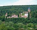
Zwingenberg Castle


-
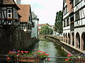
Hirschhorn am Neckar offers a picturesque view of the old town, the monastery and the castle, especially from the opposite bank of the Neckar. Several points in the city invite you to visit:
- The Hirschhorn Museum houses the remarkable "Natural History and Antiquities Collection" of the Hirschhorn innkeeper Carl Langbein and the environmental education center of the UNESCO Geopark.
- the medieval Hirschhorn Castle extends on a mountain spur above the town. It received its current form in the 16th century through a castle-like reconstruction in the Renaissance style . After that it was used as Kurmainzer's official residence. The castle has been spared major damage to this day and is therefore in a very good state of preservation. Only the inner courtyard and the tower are open to the public.
- Below the castle is the former Carmelite monastery church of the Annunciation , consecrated in 1406, with St. Anne's chapel from 1513. The church is rich in medieval epitaphs by von Hirschhorn and has a Gothic sandstone rood screen . The former monastery building has been preserved to the right of the church.
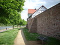
- Within the old town, which is surrounded by the almost completely preserved city defense system from the 13th and 15th centuries, there are other buildings worth seeing, including:
- Half-timbered houses from the 15th to 17th centuries Century, especially in the main street,
- the "old town hall", built in 1594 with rich ornamental framework,
- the market church, which uses the old central gate of the former city fortifications as a bell tower.
- In the Ersheim district on the opposite side of the Neckar is the Ersheimer Chapel , which was mentioned in a document in 773 in the Lorsch Codex and is considered the oldest church in the Neckar Valley .
- The bike path on the opposite bank of the Neckar offers a beautiful overview of the city of Eberbach . It is located in a widening of the Neckar Valley and like Hirschhorn on the romantic Castle Road that leads from Mannheim to Prague. Worth seeing in Eberbach:
- The historic old town has four well-preserved towers of the medieval city fortifications.
- The old town hall from 1823 on the market square is one of the most successful works of the Weinbrenner style ( classicism in Baden ).
- The oldest stone building is the Thalheimsche Haus , formerly the Electoral Palatinate cellars, hunting lodge and town hall, today the information center of the Neckartal-Odenwald Nature Park .
- Outstanding half-timbered houses are the former city palace Eberbacher Hof from the 16th century, the old bath house and the neighboring Spohr house .
- In Zwingenberg am Neckar there is the inhabited and well-preserved castle - today Schloss - Zwingenberg , originally from the 13th century. This was razed in the 14th century and rebuilt in 1403 by the Lords of Hirschhorn . Every year in August the castle festival has been held in the open air since 1983.
From the Neckar to the Main

Mosbach town hall

Mosbach market square

Eberstadt stalactite cave
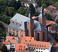
Pilgrimage church in Walldürn
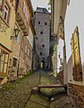
Schnatterlochtor in Miltenberg

Market in Miltenberg

Gasthof '' Zum Riesen '' in Miltenberg
City wall in Wörth as flood protection


- The market square is particularly worth seeing in Mosbach . In addition to the Mosbach town hall, there is also the Palm'sche Haus , a half-timbered house built in 1610, which is a symbol of the city and one of the most beautiful half-timbered houses in southern Germany. The oldest half-timbered house is the salt house. Next to it is the Gothic collegiate church of St. Juliana, whose beginnings go back to the 13th century, where it was part of the Mosbach monastery .
- The Eberstadt stalactite cave is located about seven kilometers south of Buchen . It can be reached via the sculpture cycle path.
- Walldürn is located in the so-called Madonnenländchen and is primarily known as a place of pilgrimage, in the center of which is the pilgrimage basilica of St. Georg . The pilgrimage developed around the blood miracle of Walldürn , which is said to have occurred around 1330. There are also numerous historical buildings in the old town area, including the town hall from 1448.
- Amorbach evolved from the former Benedictine - monastery Amorbach its baroque monastery church with rococo plasterwork still dominates the landscape of old town. Not far from the monastery church is the Fürstlich-Leiningen Palace , which is still the family seat of the Princes of Leiningen today.
On the Main river
- The old town of Miltenberg is about three kilometers off the three-country cycle path, but is worth a detour on the Main cycle path. In the historic old town there are among others:
- The Mildenburg above the old town.
- The Miltenberg City Museum . It shows the historical and cultural development of the city and in 1999 received the Bavarian Museum Prize for its conception and presentation .
- The "Schnatterloch" on the historic market square. The Schnatterlochturm offers a passage from the market square directly into the forest. Underneath this passage is the actual Schnatterloch: This is a hole that opens into a drainage channel that leads to the market square. The name Schnatter is derived from the old term "Snade", which was used to designate a border, because the rainwater ditch was originally the city boundary.
- The Hotel Zum Riesen , one of the oldest or possibly the oldest inn in Germany.
- The old town hall from 1379.
- The well-preserved city gates: the Würzburg and Mainz gates .
- In the immediate vicinity of the Mainzer Tor the Laurentius Chapel with the adjoining Laurentius Cemetery (approx. 14th century).
-
Klingenberg am Main has a small historic old town with half-timbered buildings from the 16th century.
- Probably the most beautiful half-timbered house in Klingenberg is the old town hall from 1561.
- The Klingenberg City Palace, a Renaissance building from 1560, is also located in the old town.
- The old town used to be surrounded by a city wall with three city gates, some of which have been preserved. Today the walls between the castle and the old town and a section of wall at the castle courtyard are still standing; The southern of the three city gates, the Brunntorturm, is also intact.
- In Wörth am Main there are:
- The Maritime and Shipbuilding Museum . It documents the historical development of inland shipping and shipbuilding on the Main.
- The old town. It is characterized by the medieval city fortifications and half-timbered houses.
- The fir tower from the 15th century forms the northern end of the city wall on the mains side, which has since been expanded as a flood protection wall at the same time.
- Particularly worth seeing: the town hall in the old town, the former town hall from 1600.
literature
- Leaflet 3-country cycle path, unlimited cycling in the Odenwald , available from Odenwald Tourismus GmbH and Touristikgemeinschaft Odenwald e. V.
- Topographic leisure map of the Northern Odenwald , 1: 50,000, published by Hess. Administration for soil management and geographic information, ISBN 3-89446-291-4
Web links
- 3-country cycle path (225 km) ( Memento from May 2, 2016 in the Internet Archive ) (description as PDF file)
- 3-Länder-Radweg In: Radroutenplaner Hessen.
Individual evidence
- ↑ radroutenplaner.hessen.de Accessed in October 2018
- ↑ Schnatterloch Miltenberg on Frankenwiki , accessed in November 2012