Marsbach (Billbach)
|
Marsbach Morsbach |
||
|
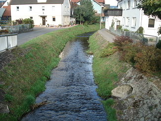
The Marsbach in Schneeberg |
||
| Data | ||
| Water code | DE : 247242 | |
| location |
Odenwald
|
|
| River system | Rhine | |
| Drain over | Billbach → Mud → Main → Rhine → North Sea | |
| source | southeast of Walldürn 49 ° 34 ′ 19 ″ N , 9 ° 23 ′ 32 ″ E |
|
| Source height | 390 m above sea level NHN | |
| confluence | west of Schneeberg with the Morre to Billbach Coordinates: 49 ° 38 ′ 24 ″ N , 9 ° 14 ′ 16 ″ E 49 ° 38 ′ 24 ″ N , 9 ° 14 ′ 16 ″ E |
|
| Mouth height | 160 m above sea level NHN | |
| Height difference | 230 m | |
| Bottom slope | 14 ‰ | |
| length | 16.4 km | |
| Catchment area | 83.661 km² | |
| Left tributaries | Eiderbach | |
|
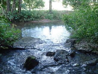
The Marsbach (from below to the center of the picture) merges with the Morre (from the left) to the Billbach (to the top right) |
||
The Marsbach or Morsbach is the right source brook of the Billbach in the Baden-Württemberg and Bavarian Odenwald .
geography
course
The Marsbach rises southeast of Walldürn near the historic Roman bathhouse . It flows in a north-westerly direction through Walldürn parallel to federal road 47 to Rippberg , where it receives its largest tributary, the Eiderbach . Then the Marsbach passes the state border to Bavaria. West of Schneeberg it joins the slightly larger Morre to the short Billbach , which then reaches the Main via the Mud .
Catchment area
The Marsbach drains over 67 km², of which a good 28 km² and thus more than 40% lie in the drainage area of its large left tributary Eiderbach, which is even slightly longer at its mouth than the Marsbach itself. The catchment area of the Marsbach is right up to almost the end constant wide, northwest running strip. The catchment area of the lower Mud lies on its short northern border, on the following border in the northeast and east that of the Erf , also called Erfa , which reaches the Main above the Mud . The following short section of the border in the southeast is also the watershed between the Main and Neckar , which is reached by the otherworldly competitor Seckach via the Jagst . The longest part of the longest part of the drainage area of the Morre borders the other long side of the catchment area in the southwest .
Tributaries
- (Stream through the Diebgrund ) (left)
- Spangelraingraben (left)
- Höpflinger Graben or Katzengraben (right)
- Spangelgraben (left)
- Wasengraben (left)
- (Bach from the hammer blade ) (right)
- (Brook from the dark blade ) (left)
- (Bach from the Sorrowful Blade ) (right)
- Eiderbach (left)
- (Bach from the Gottersklinge ) (right)
Billbach river system
Geology and landscape
The Marsbach arises on the north-western edge of the arable land to the Odenwald in a strip of the Lower Muschelkalks only a few kilometers wide . On his north-west course, after Walldürn, he already enters the eastern Odenwald, which is made up of red sandstone , in whose forest landscape he forms what is ultimately a deep kerbsohlental valley.
history
In August 2020, after a long period of drought, the Marsbach ran out of water in some sections, the dry stream bed in Walldürn, for example, was partially covered with a carpet of grass and weeds.
Web links
Individual evidence
- ↑ a b c State Institute for the Environment Baden-Württemberg (LUBW) ( information )
- ↑ Bavaria Atlas of the Bavarian State Government ( notes )
- ↑ Unusual picture: The brook has no water - Fränkische Nachrichten. In: fnweb.de. Retrieved August 26, 2020 .

