Collenberg
| coat of arms | Germany map | |
|---|---|---|

|
Coordinates: 49 ° 46 ' N , 9 ° 20' E |
|
| Basic data | ||
| State : | Bavaria | |
| Administrative region : | Lower Franconia | |
| County : | Miltenberg | |
| Height : | 140 m above sea level NHN | |
| Area : | 25.67 km 2 | |
| Residents: | 2415 (Dec. 31, 2019) | |
| Population density : | 94 inhabitants per km 2 | |
| Postcodes : | 97903, 97896 | |
| Primaries : | 09376, 09375 | |
| License plate : | MIL, OBB | |
| Community key : | 09 6 76 117 | |
| Community structure: | 3 districts | |
| Address of the municipal administration: |
Kirchplatz 2 97903 Collenberg |
|
| Website : | ||
| First Mayor : | Andreas Freiburg ( CSU ) | |
| Location of the municipality of Collenberg in the Miltenberg district | ||
Collenberg is a municipality in the Miltenberg district in Lower Franconia .
geography
Geographical location
Collenberg is located on the Main and is 13 km from Miltenberg and 18 km from Wertheim . In the Main between Collenberg and Freudenberg lies the state border between Bavaria and Baden-Württemberg . The topographically highest point of the municipality is 497 m above sea level. NN (location) on the Geiersberg northwest of Reistenhausen, the lowest is in the Main at 124.5 m above sea level. NN (location) . The Franconian Marienweg leads through Collenberg .
Community structure
Three officially named districts belong to the municipality (the type of location in brackets):
- Fechenbach ( parish village )
- Kirschfurt (village)
- Reistenhausen ( Kirchdorf )
So there is no district of Collenberg.
Neighboring communities
| Mönchberg market |
Eschau market |
|
| community Röllbach |

|
community Dorfprozelten |
| Großheubach market |
Burgstadt market |
City of Freudenberg |
Surname
The municipality of Collenberg takes its name from the Collenburg above the town .
history
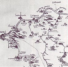
Around 1250, the Rüdt von Collenberg family settled about a kilometer east of Fechenbach. The Collenburg , which has been preserved as a ruin, was built by the males .

The community was created on April 1, 1971 as part of the regional reform in Bavaria by merging the two communities Fechenbach and Reistenhausen (with Kirschfurt).
politics
Mayor and City Council
Andreas Freiburg (CSU) has been mayor since May 1, 2020; he was elected on March 15, 2020 with 76.09% of the valid votes. His predecessor was Karl Josef Ullrich (CSU) from May 2008 to April 2020.
The municipal council consists of 14 members; in the term of office from May 2020 to April 2026 are represented:
- CSU : 8 seats (54.78%)
- SPD : 3 seats (20.93%)
- Free citizens of Collenberg : 3 seats (24.30%)
The turnout was 63.63%.
coat of arms
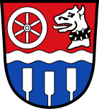
| Blazon : “Red and blue divided by a silver wavy bar; at the top side by side a six-spoke silver wheel and a silver male head with a black spiked collar; below three, two to one, growing silver pistons. " | |
traffic
The Collenberg and Freudenberg-Kirschfurt stops are on the Miltenberg West – Wertheim railway line . Here trains of the Westfrankenbahn run between Aschaffenburg , Wertheim , Lauda and Crailsheim .
On the other side of the Main is the Baden-Württemberg state road L 2310 , which in Kirschfurt is connected to the main road from Collenberg via the Bavarian state road St 2315 . The main street leads along the Collenberger Main side along the Main to Hasloch .
Public facilities
Educational institutions
- Kindergarten St. Martin with around 85 children
- Elementary school
Sports
In Collenberg there is a course for 3D archery with 33 targets.
Culture and sights
Buildings
- Ruins of the Collenburg , built by the Rüdt von Collenberg family in 1250 (see Buchen (Odenwald) )
- Fechenbach Castle, built in 1750 by the Count von Reigersberg
- Fechenbach's former synagogue of the Jewish community at Kleine Gasse 12, which was devastated during the November pogrom in 1938
- Jewish cemetery in the Reistenhausen district
Culinary specialties
- Heaven and earth (heaven is apple puree , earth is mashed potatoes ) There are also baked blood and liver sausages . Topped with roasted onions .
- Öpfelwoi (self-pressed apple wine ). Because color and taste are often quince with ge keltert . A song was specially composed about cider:
Reistenhäuser cider song “The cider is looking for his own kind”.
Public bookcase
A public bookcase has been set up in the stairwell of the town hall , which can be used as a free exchange or to take away books.
Others
The Freudenberg transmitter of the Südwestrundfunk (SWR) is located in the area of the municipality of Collenberg and thus on Bavarian territory to supply Freudenberg with FM radio programs from the SWR.
There is a campsite right on the banks of the Main .
Web links
- Collenberg community
- History portal Bavarian Lower Main
- Reistenhausen Jewish cemetery
- Collenberg: Official statistics of the LfStat
- Collenberg in the location database of the Bayerische Landesbibliothek Online . Bavarian State Library
Individual evidence
- ↑ "Data 2" sheet, Statistical Report A1200C 202041 Population of the municipalities, districts and administrative districts 1st quarter 2020 (population based on the 2011 census) ( help ).
- ^ Homepage of the community
- ↑ http://www.bayerische-landesbibliothek-online.de/orte/ortssuche_action.html ? Anzeige=voll&modus=automat&tempus=+20111122/232118&attr=OBJ&val= 1682
- ^ Wolf-Armin von Reitzenstein : Lexicon of Franconian place names. Origin and meaning . Upper Franconia, Middle Franconia, Lower Franconia. CH Beck, Munich 2009, ISBN 978-3-406-59131-0 , p. 50 ( limited preview in Google Book search).
- ^ Wilhelm Volkert (ed.): Handbook of Bavarian offices, communities and courts 1799–1980 . CH Beck, Munich 1983, ISBN 3-406-09669-7 , p. 523 .
- ↑ Mayor 2020 election results , accessed on June 13, 2020
- ^ Election results for the municipal council 2020 , accessed on June 13, 2020
- ^ Entry on the coat of arms of Collenberg in the database of the House of Bavarian History
- ^ Website of the archery course in Collenberg
- ↑ Memorial sites for the victims of National Socialism. A documentation, volume 1. Federal Agency for Civic Education, Bonn 1995, ISBN 3-89331-208-0 , p. 121


