Großheubach
| coat of arms | Germany map | |
|---|---|---|

|
Coordinates: 49 ° 44 ' N , 9 ° 14' E |
|
| Basic data | ||
| State : | Bavaria | |
| Administrative region : | Lower Franconia | |
| County : | Miltenberg | |
| Height : | 132 m above sea level NHN | |
| Area : | 18.99 km 2 | |
| Residents: | 5079 (Dec. 31, 2019) | |
| Population density : | 267 inhabitants per km 2 | |
| Postal code : | 63920 | |
| Area code : | 09371 | |
| License plate : | MIL, OBB | |
| Community key : | 09 6 76 125 | |
| Market structure: | 4 districts | |
Market administration address : |
Rathausstrasse 9 63920 Großheubach |
|
| Website : | ||
| Mayor : | Gernot winter | |
| Location of the Großheubach market in the Miltenberg district | ||
Großheubach is a market in the Miltenberg district in Lower Franconia .
geography
Geographical location
The community is located in the Main Valley and is framed by the foothills of the Spessart and Odenwald . Großheubach is located on the Franconian red wine hiking trail . Further north on the Main, the next place today is Klingenberg am Main with the district of Röllfeld . The church of St. Michaelis was located between Röllfeld and Großheubach until 1778 . Probably the associated settlement was the latest in the time of the Thirty Years' War about 1630 because of an early 17th century plague - epidemic abandoned. Opposite on the other side of the Main is Kleinheubach . The topographically highest point of the municipality district is located at 439 m above sea level. NN on the summit of the Ospis northeast of the village, the lowest is in the Main at 120.5 m above sea level. NN .
Community structure
There are four districts (the type of settlement in brackets):
- Engelberg (monastery)
- Großheubach (main town and administrative seat)
- Klotzenhof (village)
- Roßhof ( hamlet )
Neighboring communities
| Community Laudenbach |
City of Klingenberg am Main |
community Röllbach |

|
Community Collenberg |
|
| Kleinheubach market |
City of Miltenberg |
Burgstadt market |
Surname
etymology
The place name Großheubach comes from the Heubach , which flows into the Main in the municipality. The addition large should distinguish the place from the place of the same name on the opposite side of the Main.
Earlier spellings
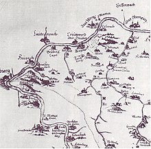
Earlier spellings of the place from various historical maps and documents:
|
|
history
Großheubach was first mentioned in a document that was made out between 1012 and 1121. Around 1200 it was owned by the Lords of Klingenberg , the Lords of Bickenbach and the Teutonic Order . The first chapel was built around 1300 on the Rulesberg, now Engelberg.
During the time of the tribal duchies , the place belonged to the Duchy of Franconia .
In 1483 Großheubach belonged to the ore monastery of Mainz . The historic town hall was built in 1612. The Capuchins founded Engelberg Monastery on the Engelberg in 1630 . In 1814 Großheubach came to the Kingdom of Bavaria . In 1828 the Franciscans took over Engelberg Monastery. The current parish church emerged from the expansion of the old church in 1896–1899 .
In 1862 the district office of Obernburg was formed, on whose administrative area Großheubach was located. On January 1, 1880, however, Großheubach came to the Miltenberg district office on the occasion of the reform of the layout of the Bavarian district offices . As everywhere in the German Reich , the term district was introduced in 1939. Großheubach was now one of the 31 communities in the old district of Miltenberg . On July 1, 1972, this merged with the district of Obernburg am Main to form the new district of Miltenberg .
politics
Municipal council
The municipal council consists of 20 members. The municipal council election on March 15, 2020 led to the result shown on the right and thus to the following distribution of seats in the municipal council:
mayor
Gernot Winter (CSU) has been First Mayor since May 1, 2020. He was elected in the runoff election on March 29, 2020 with 54.4 percent of the vote. His predecessor Günther Oettinger (* 1950) was mayor from May 1990 to April 2020.
- Benedikt Oettinger: (1860–1870 community leader, from July 1, 1869: mayor)
|
|
societies
The club "TSV Großheubach" has existed since 1900 and is divided into the departments basketball, football, gymnastics, table tennis and volleyball. [1]
coat of arms
| Blazon : “Split by silver and red; in front a floating black St. Andrew's cross with pawbones, behind a six-spoke silver wheel. " | |
Buildings
- Parish Church of St. Peter
The parish church (Patrozinium Cathedra Petri - "Petri Stuhlfeier") is already old: A pastor is mentioned for the first time in 1249, the church at that time was made of wood. A bell is mentioned in 1519, but it no longer exists. In 1609 the wooden structure was replaced by a massive fortified church with defensive wall , battlement and battlements (in Romanesque style). From 1896–1899 extensive alterations and extensions are carried out, which lead to its current neo-Gothic appearance. In 1949 four new bells are purchased. On August 1, 1958, a severe storm led to the destruction of the church tower . In 1987/88 the church was renovated and the state was restored after the renovations at the end of the 19th century.
- Historic town hall
The historic town hall was built in 1611/1612 by the master builder Otto Oswald Heppele in the old Franconian half-timbered construction. The house served as the seat of a subordinate for the office of Prozelten. The ground floor was used as a prison. Johann Schweikhard , Archbishop of Mainz and Elector, as well as Caspar Herr zu Eltz, Electoral Mainz Grand Court Master, councilor and bailiff zu Prozelten acted as builders .
- Abendanz'sches Haus
The Abendanz'sche Haus is a half-timbered house built around 1600 in the center of Großheubach. Over the centuries, the building has undergone some changes. After the restoration between 1987 and 1990, the framework was exposed and the original facade was restored. The house was used by the wine merchant Johann Simon Abendanz and the last abbot of the Amorbach monastery , among others .
- Monastery Engelberg
The Engelberg Monastery with its famous pilgrimage church was founded around the 1300th The buildings erected in 1630 for the order of the Capuchins were handed over to the Franciscans (OFM) in 1828 by order of King Ludwig I , who still operate the monastery today. Engelberg, located at 250 m above sea level, can be reached via the 612 so-called Angel Staffeln made of red sandstone .
- Historical pagan cult site
The Hunnenstein or the Heunenschüssel is located on a hill near today's Engelberg Abbey. Circular depressions are roughly carved into the several meter high sandstone boulder.
- On the way to the Klotzenhof there is a monument to a mythical creature , here called Elfetritschle , otherwise more common in the Palatinate.
- The place is the end of the medieval 111 km long " Eselsweg " over the heights of the Spessart.
Sons and daughters of the church
- August Steuer (1902–1969), American publisher, sports official, and community benefactor
- Guido Kratschmer (born January 10, 1953), track and field athlete (decathlete) and Olympic medalist
Web links
Individual evidence
- ↑ "Data 2" sheet, Statistical Report A1200C 202041 Population of the municipalities, districts and administrative districts 1st quarter 2020 (population based on the 2011 census) ( help ).
- ↑ Dieter Michael Feineis: Grub Ingen. In: Würzburger Diözesan Geschichtsblätter - special edition . 55th volume, Diocese of Würzburg, Würzburg, pp. 53–87, online = online as PDF
- ^ Franz Schaub, Spessart walks, Süddeutscher Verlag, Munich 1982, ISBN 3-7991-6165-1 , p. 49
- ↑ http://www.bayerische-landesbibliothek-online.de/orte/ortssuche_action.html ? Anzeige=voll&modus=automat&tempus=+20111123/183038&attr=OBJ&val= 1689
- ↑ a b Wolf-Armin von Reitzenstein : Lexicon of Franconian place names. Origin and meaning . Upper Franconia, Middle Franconia, Lower Franconia. CH Beck, Munich 2009, ISBN 978-3-406-59131-0 , p. 89 ( limited preview in Google Book search).
- ↑ Monumenta Germaniae Historica Epistolae p. 133
- ^ Norbert Allmann: 1000 Years of Vielbrunn 1012–2012 . City of Michelstadt, Michelstadt 2012, ISBN 3-924583-50-1 , p. 26-30 .
- ↑ [ https://www.wahlen-in-mil.de/wahlverbindungen/kommunalwahlen_2020/09676125/html5/Gemeinderatswahl_Bayern_74_Gemeinde_Markt_Grossheubach.html Municipal Council Election Markt Großheubach 2020, overall result], accessed on June 15, 2020
- ↑ Greetings from the mayor. Großheubach community, accessed on August 6, 2020 .
- ^ Matthias Klotz: Schultheißen, community leader and mayor in Großheubach . In: Community of Großheubach (ed.): The writing for the festival. 400 years town hall Großheubach . Self-published, Großheubach 2012, p. 9-11 .
- ↑ http://www.grossheubach.de/rathaus-buergerservice/buergermeister/historie/
- ^ Entry on the coat of arms of Großheubach in the database of the House of Bavarian History
- ↑ Karl-Josef Kraus: 90 years of church expansion St. Peter in cathedra Großheubach . Ed .: Parish of Großheubach. 1989, p. [20] .
- ^ Karl-Josef Kraus: 90 years of church expansion St. Peter in cathedra . Ed .: Parish of Großheubach. Großheubach 1989.
- ^ Website Großheubach - Sights: Catholic parish church St. Peter , accessed on the 16th anniversary of 2018


