
Donkey path
The Eselsweg is a historic trade route and a long-distance hiking trail through the Spessart in Hesse and Bavaria . It is 111 km long and leads from Schlüchtern to Großheubach near Miltenberg .
description
The path is one of the so-called old streets and has probably been in use for 2,000 years. It gets its name from the donkey caravans in the Middle Ages that brought salt from Bad Orb to Miltenberg for embarkation.
Today, the Eselsweg is a popular hiking trail that leads through the Spessart forests as a high-altitude path on Eselshöhe with almost no local contact . The Spessart Association has marked the path with a black "E" on a white background and maintains it.
Above Wiesen am Greifenberg, it crosses a second historic Spessart trade route, Birkenhainer Strasse, at Dr.- Karl Kihn -Platz . The Degen path has also ended there since 2011 .
Waypoints
Distinctive waypoints are:
- Bellinger Wait
- Steinau adventure park
- Wiesbüttsee
- Dr. Karl-Kihn-Platz
- Kreuzkapelle
- English people
- Pollasch monument
- Echterspfahl
- Luitpoldshöhe Castle
- Hunnenstein
- Engelberg Monastery
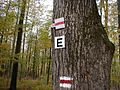
Hiking sign of the donkey path
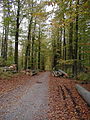
View of the Eselsweg near the Echterspfahl
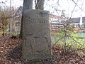
Memorial stone for the donkey path near Weibersbrunn

Dr.-Karl-Kihn-Platz
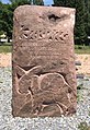
Memorial stone to the Eselsweg above Weibersbrunn


Web links
literature
- Brigitte Wenninger: The donkey path. Hiking in the Spessart. CoCon-Verlag, Hanau 2009, ISBN 978-3-937774-74-9