
Echterspfahl
|
Echterspfahl
Community Weibersbrunn
Coordinates: 49 ° 55 ′ 7 ″ N , 9 ° 20 ′ 26 ″ E
|
|
|---|---|
| Height : | 490 m above sea level NHN |
| Residents : | 6 (1987) |
| Postal code : | 63879 |
| Area code : | 06094 |
 Forsthaus Echterspfahl
|
|
Echterspfahl is a district of the municipality of Weibersbrunn in the Lower Franconian district of Aschaffenburg . The only property is the Echterspfahl forest house .
location
The desert is an enclave of the municipality in the municipality-free area Rohrbrunner Forst and is located in a forest clearing, about 2 km southwest of Weibersbrunn. The Echterspfahl is a prominent point on the ridge of the Eselshöhe in the Spessart , a German low mountain range . This is where the Eselsweg (Eselsweg) , which runs in north-south direction , an old trade route that is now accessible as a long-distance hiking trail , crosses with the old post road from Würzburg to Frankfurt am Main , which is expanded to federal road 8 and is opened in the year In 2007 it was downgraded to State Road 2312 . The hill is also called "Jockel".
history
It has been historically proven that at the time when the forest belonged to Kurmainz , this striking point was a meeting place for the hunters and drivers of the Archbishops and Electors of Mainz. When the territory passed to the Kingdom of Bavaria , the Bavarian forest authority set up a forest service here. At this point was the border between the Bavarian state forest and the forest property of the descendants of the Echter family, the Counts of Ingelheim . The Bavarian forester on the Echterspfahl soon received a license from his superior authority to serve his guests with food and drinks. This is how today's excursion restaurant came into being.
To this day, there are not only old legends about Echterspfahl, but also modern anecdotes. In the surrounding communities, the Echterspfahl inn is also known as the “Jockel”. There is also a legend in the book Spessartsagen by Valentin Pfeifer under the title "Der Jockel und der Jockenmüller".
Legend of origin
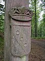
The name "Echterspfahl" goes back to a legend according to which three brothers of the Echter family worked as robber barons in the nearby Odenwald . Pursued by the troops of Emperor Barbarossa , they withdrew to the Spessart and settled in three different places for security reasons. From time to time they met in this prominent location for meetings and tied their horses to a pole with three metal rings.
Heraldic impact


These three rings are said to have been the origin of the coat of arms of the Echter family, which shows a white, oblique left bar on a blue shield, and in many representations also oblique bar, which is covered with three blue rings. The coat of arms with the three blue rings is now part of the coat of arms of the Aschaffenburg district .
A wooden post with three metal rings still stands a few meters from the excursion restaurant, directly on federal road 8 (or since 2007, state road 2312 ).
today
In the old forester's house Echterspfahl there is now a restaurant for excursions, which is popular with hikers, cyclists and motorcyclists. A few kilometers away are the Luitpoldshöhe hunting lodge in the Rohrbrunn district and the Mespelbrunn moated castle ( Mespelbrunn municipality ).
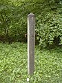
The "original" real stake

Genuine post with the three rings and carved genuine coat of arms
Boundary stone with the coat of arms of the Echter family near the Echterspfahl


Web links
- Homepage of the forester's house Echterspfahl
- Sagen.at "Echterspfahl"
- Echterspfahl near Weiberbrunn - The Jockel
- Hiking book Spessart Odenwald, Tour 1 ( Memento from March 25, 2011 in the Internet Archive )
Individual evidence
- ↑ Bavarian State Office for Statistics and Data Processing (Ed.): Official local directory for Bavaria, territorial status: May 25, 1987 . Issue 450 of the articles on Bavaria's statistics. Munich November 1991, DNB 94240937X , p. 357 ( digitized version ).