
List of architectural monuments in Obernburg am Main
The monuments of the Lower Franconian town of Obernburg am Main are compiled on this page . This table is a partial list of the list of architectural monuments in Bavaria . The basis is the Bavarian Monument List , which was first drawn up on the basis of the Bavarian Monument Protection Act of October 1, 1973 and has since been managed by the Bavarian State Office for Monument Preservation . The following information does not replace the legally binding information from the monument protection authority. This list reflects the update status from April 16, 2020 and contains 69 architectural monuments.

Ensembles
Ensemble old town Obernburg a.Main
The ensemble includes the old town of Obernburg within its medieval fortifications. Among the towns on the Main, built over Roman forts , in the area of the former wet Limes, Obernburg is characterized by its floor plan, which largely depicts the ancient castrum: the main-parallel main street (Römerstraße) coincides with the former via principalis, the Badgasse perpendicular to it with the via praetoria together. The medieval urban area extends far beyond the boundary line of the Roman castrum, especially to the north, where the former self-fortified parish is located. The structure of the town, which was expanded into a town by the Mainz ore monastery in the first half of the 14th century, is as follows: within the rectangular border through the former town wall, the Römerstraße as the main street runs through the length of the town, shifted uphill from the central axis; side streets branch off at right angles from it; In the broader half of the city on the side of the river, these are more numerous and also connected to one another by an alleyway parallel to the main street (lower alley / Pfaffengasse); the Mainstrasse leading to the Main crossing appears to be emphasized by its greater width; a marketplace is missing. The city is not only characterized by its floor plan, but also by its closed stock of half-timbered houses. Corresponding to the gradient typical of every medieval country town, stately properties can be found on Römerstraße on large, lined up plots that extend uphill to the former city wall, and in the side streets on the side of the river, a smaller mix of craftsmen's yards. The mostly plastered buildings from the 16th to 19th centuries Century are partly gable, partly eaves. In the Römerstraße the position alternates, in the side streets eaves predominate, but sometimes there are rows of gable-independent houses, mostly with half-hipped houses. A historic monumental building has been missing since the new parish church was built. The only accents are outstanding houses (such as Römerstrasse 18 and 41) as well as the towers of the city fortifications and the two city gates that complete Römerstrasse. Boundaries: Course of the former city wall, marked by the outer side of the Upper and Lower Wallstrasse. File number: E-6-76-145-1.
City fortifications
The fortifications surrounding the city in a rectangle were laid out from 1344, and renewed and strengthened in the 15th and 16th centuries. After the demolition of the city walls in the 19th century, only a few wall sections have survived: at the upper gate to the west and a short section to the west and east at the lower gate, and to the north to the alms tower. The preserved towers stood in the four corners and in the middle of the western long side of the wall. All towers are made of sandstone with stone edges and frames and, with the exception of the round tower, have a rectangular floor plan. File number: D-6-76-145-2.
| location | object | description | File no. | image |
|---|---|---|---|---|
| Almosenturm ( location ) |
Alms Tower | South-eastern tower of the city fortifications, 2nd half of the 14th century and 1st half of the 16th century, with crenellated crown projecting on a round arch and tapered superstructure also with projecting crenellated crown, lavatory, gargoyle | D-6-76-145-2 |
 more pictures |
| Almosenturm ( location ) |
city wall | to the north then section of the city wall, 2nd half of the 14th century | D-6-76-145-2 | |
| Hexenturm ( location ) |
Witch tower | North-western tower of the city fortifications, 2nd half of the 14th century and 1st half of the 16th century, with a crenellated crown projecting onto a round arched frieze, lavatory, gargoyle, installation of a guard room in the 16th century | D-6-76-145-2 |
 more pictures |
| Near Runde-Turm-Straße ( location ) |
Round tower | in the middle of the western long side of the city fortifications, with crenellated crenellated on a round arched frieze, toilet bay, gargoyle | D-6-76-145-2 |
 more pictures |
| Upper gate ( location ) |
Upper gate or clock tower | Tower gate over a rectangular floor plan with round arched passage and side claw stones from the former portcullis, access via external stairs along the inside of the city wall adjoining to the west through shoulder arched door, sparse exposure of the upper floor through Renaissance windows and medieval loopholes, plastered building with stone edges and frames, sandstone, in the core 2nd half 14th century, slate half-hipped roof with double-tiered hooded roof lantern, marked 1586, clock with elaborate dial, marked 1523, the pedestrian gates in the lateral city wall connections 19./20. century | D-6-76-145-26 |
 more pictures |
| Bag tower ( location ) |
Bag tower | South-western tower of the city fortifications, with a crenellated crown projecting onto a round arch frieze | D-6-76-145-2 |
 more pictures |
| Untere Wallstraße 22 a ( location ) |
Stork's nest or pool tower | North-eastern tower of the city fortifications, 2nd half of the 14th century and 1st half of the 16th century, with a missing end | D-6-76-145-2 |
 more pictures |
Architectural monuments according to districts
Obernburg am Main
Four street scenes of particular importance, so-called "special areas", are identified within the old town.
Upper Alley
Boundary: Obere Gasse 2–30 even house numbers.
| location | object | description | File no. | image |
|---|---|---|---|---|
| Obere Gasse 4 ( location ) |
Residential building | Two-storey, gable-independent gable roof building with half-timbered upper storey protruding far at the sides, ground floor modified, 18th century | D-6-76-145-17 |
 more pictures |
| Obere Gasse 8 ( location ) |
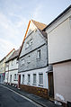
Residential building | two-storey hipped roof building with half-timbered upper storey, marked 1556 | D-6-76-145-18 |
 more pictures |
| Obere Gasse 12 ( location ) |
Residential building | Two-storey plastered half-timbered house with a mansard roof and half-hip facing the street, ground floor changed, around 1800 | D-6-76-145-20 |
 more pictures |
| Obere Gasse 18 ( location ) |
Residential building | two-storey plastered half-timbered house in a corner position with overbuilt gate entrance and crooked hip, end of the 18th century | D-6-76-145-22 |
 more pictures |
Pfaffengasse
Boundary: Pfaffengasse 6-24 (even house numbers).
Pfaffengasse 8

Pfaffengasse 12

Pfaffengasse 14

Pfaffengasse 16

Pfaffengasse 18

Pfaffengasse 20

Pfaffengasse 22

Pfaffengasse 24


Roman road
Boundary: Römerstrasse 10–14, 16–19, 21, 26–51, 53–62, 64, 66, 68–73, 79, 81.
| location | object | description | File no. | image |
|---|---|---|---|---|
| Römerstrasse 13 ( location ) |
Residential building | two-storey plastered timber-framed house with a cantilevered upper storey and mansard roof, 17th / 18th century Century, roof changed, remnants of a former flight of stairs or stone bench, sandstone, 18th century | D-6-76-145-29 |
 more pictures |
| Römerstrasse 17 ( location ) |
Residential building | three-storey eaves half-timbered house with a mansard roof with a strong projecting overhanging the alleyways, 17th / 18th centuries century | D-6-76-145-31 |
 more pictures |
| Römerstraße 18 ( location ) |
Former inn | now a banking institute, two-storey saddle roof building in corner position with plastered half-timbered upper storey and massive tail gable with Renaissance ashlar elements in the south, end of the 16th century, extended to the north in the 20th century, storeys and roof structures changed | D-6-76-145-32 |
 more pictures |
| Römerstrasse 19 ( location ) |
Residential building | Two-storey hipped roof building with gate passage and half-timbered upper floor, marked 1722, ground floor changed | D-6-76-145-33 |
 more pictures |
| Römerstrasse 21 ( location ) |
Residential building | two-storey hipped roof building with half-timbered upper storey in corner position, 16./17. Century, ground floor and eaves changed | D-6-76-145-34 |
 more pictures |
| Römerstrasse 26 ( location ) |
Outbuildings | two-storey half-timbered building with carved corner posts and mansard roof, 17th / 18th centuries century | D-6-76-145-35 |
 more pictures |
| Römerstrasse 28 ( location ) |
Residential building | Two-storey plastered half-timbered house in the corner of a narrow alley, with originally a crooked roof, now a saddle roof, massive ground floor wall with Renaissance profiles, sandstone, mid-16th century | D-6-76-145-36 |
 more pictures |
| Römerstraße 34, 36 ( location ) |
Residential building | two-storey half-timbered building with half-hipped roof, around 1500, demolished in 1979 and reconstruction | D-6-76-145-37 |
 more pictures |
| Römerstrasse 35 ( location ) |
Residential building | two-storey gable-independent saddle roof building with half-timbered upper storey, 17th century, ground floor changed | D-6-76-145-38 |
 more pictures |
| Römerstraße 37 ( location ) |
Residential building | Two-storey half-hipped roof building with half-timbered upper storey in corner position, 18th century ground floor changed | D-6-76-145-39 |
 more pictures |
| Römerstrasse 38 ( location ) |
Demolition and new construction | D-6-76-145-40 | ||
| Römerstrasse 40 ( location ) |
Residential building | three-storey half-hipped roof building with half-timbered upper storeys in corner position, 17th / 18th century Century, rebuilt around 1980 with reuse or reconstruction of the framework | D-6-76-145-41 |
 more pictures |
| Römerstraße 41 ( location ) |
Residential building | Two-storey hipped roof building with half-timbered upper storey, ground floor with ashlar edges and frames, around 1600 | D-6-76-145-42 |
 more pictures |
| Römerstraße 41 ( location ) |
inset Roman Weihaltar | Sandstone, around 200 | D-6-76-145-42 |
 more pictures |
| Römerstraße 41 ( location ) |
House Madonna with child | Wood, 18th century | D-6-76-145-42 |
 more pictures |
| Römerstrasse 42 ( location ) |
Inn | two-storey eaves gable roof building with half-timbered upper storey, 17th century, ground floor changed | D-6-76-145-43 |
 more pictures |
| Römerstrasse 42 ( location ) |
Gatehouse | two-storey eaves gable roof building with half-timbered upper storey and round archway with butcher's mark, sandstone, marked 1606 | D-6-76-145-43 |
 more pictures |
| Römerstrasse 47 ( location ) |
Residential building | Two-storey, eaves-standing half-hipped roof building with half-timbered upper storey, around 1700, ground floor changed | D-6-76-145-44 |
 more pictures |
| Römerstraße 62 ( location ) |
town hall | Two-storey saddle roof building with stepped gables, ground floor with pointed arch arcades, tiled roof with slotted pointed dormers, plastered construction with ashlar structures, sandstone, neo-Gothic, end of the 19th century, in front of the north gable, the remains of an older stair tower with plastered half-timbered upper floor, embedded gargoyles on the ground floor, late Gothic 17th century, sandstone Lintel, sandstone 15./16. Century, gable roof 19th century | D-6-76-145-45 |
 more pictures |
| Römerstraße 62 ( location ) |
town hall | Wappenstein, sandstone, 14./15. century | D-6-76-145-45 |
 more pictures |
| Römerstrasse 68 ( location ) |
Demolition and new construction | D-6-76-145-46 | ||
| Römerstrasse 69 ( location ) |
Courtyard gate | Sandstone, 17th century | D-6-76-145-47 |
 more pictures |
| Römerstrasse 70 ( location ) |
Demolition and new construction | D-6-76-145-48 |
Lower alley
Boundary: Untere Gasse 1–30, 32, Badgasse 27, Kaisergasse 13, 18, Obere Gasse 11, 13.
| location | object | description | File no. | image |
|---|---|---|---|---|
| Untere Gasse 18 ( location ) |
cornerstone | Reliefs with crossed keys, star flower and initials, sandstone, inscribed 1851 | D-6-76-145-52 |
 more pictures |
| Untere Gasse 24 ( location ) |
Residential building | Two-storey plastered half-timbered house with a strong protrusion and a crooked hip roof, in the corner, in the 17th century | D-6-76-145-53 |
 more pictures |
| Untere Gasse 32 ( location ) |
Residential building | two-storey half-timbered house with gable roof in corner position, 18th century | D-6-76-145-54 |
 more pictures |
| Untere Gasse 32 ( location ) |
Courtyard wall | with door frames, sandstone, 18./19. century | D-6-76-145-54 | |
| Obere Gasse 11 ( location ) |
Residential building | two-storey half-timbered house with half-hipped to the street, 17th century, renovation 1996 | D-6-76-145-19 |
 more pictures |
| Obere Gasse 11 ( location ) |
Outbuilding with covered gate passage | two-storey half-timbered house with a sloping floor plan with overbuilt gate passage, 19th century, loft changed | D-6-76-145-19 |
 more pictures |
| Obere Gasse 13 ( location ) |
Residential building | Two-storey plastered half-timbered house with a protruding upper storey, in a corner position, gable roof in the west with a half-hip, around 1600 | D-6-76-145-21 |
 more pictures |
Rest of the city center
| location | object | description | File no. | image |
|---|---|---|---|---|
| Am Stiftshof 1 ( location ) |
Catholic parish church of St. Peter and Paul | Church interior, pillar-free hall over an elongated heptagonal floor plan with a copper sheet-covered folding roof and complete windowing of the gable triangles, concrete skeleton construction, 1964; with equipment | D-6-76-145-3 |
 more pictures |
| Am Stiftshof 1 ( location ) |
Catholic parish church of St. Peter and Paul | Tower, three-storey church tower of the previous building that acts as a free-standing campanile, has a square floor plan with a slate two-tier Welsch hood, plastered building with sandstone structures and a tower clock above the bell storey, 1591 | D-6-76-145-3 |
 more pictures |
| Am Stiftshof 1 ( location ) |
Catholic parish church of St. Peter and Paul | gravestones from the 16th and 17th centuries in the open tower basement Century | D-6-76-145-3 |
 more pictures |
| Badgasse 8, 10 ( location ) |
Residential building | Eaves two-storey saddle roof building with ornamental half-timbered upper storey, marked 1722. Ground floor and windows renewed | D-6-76-145-4 |
 more pictures |
| Katharinenstrasse 5 ( location ) |
Wayside shrine | Statue with a fully plastic figure top, St. Anna Selbdritt, inscribed 1714 | D-6-76-145-7 | |
| Lindenstrasse ( location ) |
Wayside shrine | Statue with arched top with relief depictions: Madonna and Child / Fall of the Cross / St. Joseph and Child, crowned with Corpus Christi, sandstone, inscribed 1712 | D-6-76-145-9 |
 more pictures |
| Maing gardens ( location ) |
Garden pavilion | single-storey half-timbered building on brick sandstone pillars, with a pyramid roof from the 18th century | D-6-76-145-58 |
 more pictures |
| Maing gardens ( location ) |
Garden and garden wall | Sandstone, 18th / 19th centuries Century, course partially changed in the 20th century | D-6-76-145-58 |

|
| Mainstrasse 1 ( location ) |
Former town clerk's house | Benefit house since 1829, museum after 1954, now town hall, two-storey gable roof with half-hipped roof on the back with half-timbered upper storey, 17th century | D-6-76-145-10 |
 more pictures |
| Mainstrasse 3 ( location ) |
Inn | Eaves two-storey saddle roof building with half-timbered upper storey, 17th century and formerly overbuilt gate passage with half-timbered storey and mansard roof, 18th century, ground floor completely changed | D-6-76-145-11 |
 more pictures |
| Mainstrasse 5 ( location ) |
Residential building | Gable-independent two-storey saddle roof building with half-hipped to the street and slated or plastered projecting half-timbered upper floor, 17th / 18th. Century changed the ground floor | D-6-76-145-12 |
 more pictures |
| Mainstrasse 6 ( location ) |
Residential building | Former villa with park, two-story hipped roof building with gables and corner tower, neo-renaissance, white clinker bricks with red sandstone, marked 1900 | D-6-76-145-13 |
 more pictures |
| Mainstrasse 9, 11 ( location ) |
Residential building | Residential building, two-storey saddle roof construction over high basement plinth with plastered half-timbered upper storey in corner position, basement access under north gable marked 1544 | D-6-76-145-16 |
 more pictures |
| Mainstrasse 5, 9 ( location ) |
archway | with pedestrian gate, sandstone, marked 1551 | D-6-76-145-16 |
 more pictures |
| Mainstrasse 10 ( location ) |
Residential building | two-storey saddle roof building with half-timbered upper storey in corner position, 17th / 18th century. century | D-6-76-145-15 |
 more pictures |
| Mömlingtalring 107 ( location ) |
Wayside shrine | Simple base with inscription, Tuscan column, top with reliefs of St. Trinity and saints, re. 1721 | D-6-76-145-156 | |
| Near Kapellengasse ( location ) |
Catholic Chapel of St. Anna | Flat-roofed hall building with a rectangular floor plan, 13th century with retracted groin-vaulted rectangular choir from 1559, saddle roof and slated roof turret with pyramid helmet, plastered building with stone edges and frames, on the south side outer pulpit, chapel probably above Mithras shrine of the 2nd / 3rd century. Century erected (excavation finds); with equipment | D-6-76-145-5 |
 more pictures |
| Near Kapellengasse ( location ) |
Wayside chapel | neo-Gothic rectangular building with a three-sided choir, sandstone cuboid with ashlar components and gable cross, 2nd half of the 19th century | D-6-76-145-8 | |
| Near Kapellengasse ( location ) |
graveyard | Cemetery wall, sandstone, probably medieval, renewed in the 20th century, with pillar portal (around 1800) | D-6-76-145-6 | |
| Near the pilgrim path ( location ) |
Picture house | Sandstone with a metal cross crown, marked 1872, Madonna modern | D-6-76-145-60 | |
| Römerstrasse 11 ( location ) |
Residential building | two-storey plastered half-timbered house with a cantilevered upper storey and half-hip roof, 17th / 18th century. century | D-6-76-145-28 |
 more pictures |
| Römerstrasse 9 ( location ) |
Cultivation | Covered gate passage with hipped roof, 18./19. century | D-6-76-145-28 |
 more pictures |
| Römerstrasse 15 ( location ) |
Residential building | Two-storey plastered half-timbered house with a protruding upper storey, facing the gable in a courtyard-like cul-de-sac, in the core 17th century | D-6-76-145-30 | |
| Römerstrasse 80 ( location ) |
District Court | Two-storey hipped roof building with a gabled central risalith, in the gable relief with Bavarian lions holding coats of arms, entrance on the southern narrow side accentuated by gabled entrance and parapet coronation, sandstone cuboid structure with stone structure, neo-baroque, marked 1900 | D-6-76-145-49 |
 more pictures |
| Römerstrasse ( location ) |
Lower gate | round archway between two pillars imitating a fortified tower, upper end with decorative battlements over console frieze, sandstone, after 1839, the side pedestrian gates in the city wall probably 20th century | D-6-76-145-27 |
 more pictures |
| Near Römerstraße ( location ) |
War memorial | Rectangular wall recess with stone benches on the side, in front of the front wall a semicircular fountain with an inscription in a trophy cartridge, a lion lying on the wall crown, sandstone, after 1871 | D-6-76-145-50 |

|
| Schmiedgasse 2 ( location ) |
Residential building | two-storey gable-independent half-hipped roof building, 18th / 19th centuries century | D-6-76-145-51 | |
| Untere Wallstraße 10 ( location ) |
Former mill | single-storey sandstone hipped roof building with two storeys at the foot of the slope, 18th / 19th centuries Century, in the second half of the 19th century expanded to a three-wing system, conversion to a music school in 1988 | D-6-76-145-55 |

|
| Vorderer Mühlrain ( location ) |
Crucifixion group with assistants | Sandstone, inscribed, 1669 | D-6-76-145-59 |
Eisenbach
| location | object | description | File no. | image |
|---|---|---|---|---|
| Am Harzofen 2 ( location ) |
Residential stable house | Two-storey saddle roof building with half-timbered upper storey, marked 1755/1955 | D-6-76-145-63 | |
| Brückenstrasse 4 ( location ) |
St. Nepomuk statue | Sandstone, marked 1868, rebuilt in 1946 after being destroyed in the war | D-6-76-145-70 | |
| Hart ( location ) |
Wayside shrine | Image pillars with cube top, cross-domed roof and cross crown, on three sides with identical crucifixion, sandstone, top around 1700, shaft and base renewed in the 20th century | D-6-76-145-72 | |
| Im Gillwing ( location ) |
crossroads | Cross with corpus above corridor altar, sandstone, marked 1787, completely renewed, 1st half of the 20th century | D-6-76-145-73 | |
| Kirchstrasse 24 ( location ) |
Catholic parish church of St. Johann Baptist | West tower on a square floor plan, plastered building with Gothic stone framing and edges, sandstone, 1401; the bell storey with a tent roof and four gables, slated, probably 19th century | D-6-76-145-61 | |
| Kirchstrasse 24 ( location ) |
Catholic parish church of St. Johann Baptist | to the south, then, St. Barbara Chapel, single-storey saddle roof building, plastered with ashlar frames and edges, sandstone, in the core probably still Romanesque | D-6-76-145-61 | |
| Kirchstrasse 24 ( location ) |
Catholic parish church of St. Johann Baptist | Eastern nave extension with gable roof, sandstone with ashlar structures, 1748/50 | D-6-76-145-61 | |
| Kirchstrasse 24 ( location ) |
Catholic parish church of St. Johann Baptist | raised, wide transept with hipped roof and choir closed on three sides and sacristy 1936; with equipment | D-6-76-145-61 | |
| Kirchstrasse 24 ( location ) |
Catholic parish church of St. Johann Baptist | Roman inscription stones from the previous building recovered and placed on the Barbara Chapel, sandstone, 2nd century | D-6-76-145-61 | |
| Mirabellenstrasse ( location ) |
Wayside shrine | Statue with cross-roof niche housing, sandstone, marked 1724, renovated in 1879 | D-6-76-145-71 | |
| Near Kirchstrasse ( location ) |
Cemetery cross | Sandstone, marked 1899 | D-6-76-145-62 | |
| Odenwaldstraße 3 ( location ) |
Farmhouse | Two-storey half-timbered house on the eaves side above a high sandstone basement base with overbuilt gate passage. Gable roof over the main wing with a crooked hip, 19th century | D-6-76-145-67 | |
| Odenwaldstraße 56 ( location ) |
Wayside shrine or wayside cross | no longer available at the marked location | D-6-76-145-74 | |
| Raiffeisenstrasse 20 ( location ) |
Residential building | two-storey, gable-independent half-timbered house with saddle roof, 17th / 18th centuries Century, disguised in the 20th century | D-6-76-145-64 | |
| Raiffeisenstrasse 24 ( location ) |
Residential building | two-storey, gable-independent half-timbered house, 17th / 18th centuries Century, disguised in the 20th century | D-6-76-145-65 | |
| Raiffeisenstrasse 26 ( location ) |
Plastered half-timbered house | 17./18. century | D-6-76-145-66 |
Cooking mill
| location | object | description | File no. | image |
|---|---|---|---|---|
| At the Wehrinsel 3 ( location ) |
Watermill with a three-wing courtyard | South wing, residential and mill house, two-part originally two-storey sandstone house with half-hipped mansard roofs, 2nd half of the 19th century, brick addition to the eastern part of the house, 1st third of the 20th century; Furnishing | D-6-76-145-76 | |
| At the Wehrinsel 3 ( location ) |
Watermill with a three-wing courtyard | North wing, two-part outbuilding, one or two-storey sandstone building with a gable roof | D-6-76-145-76 | |
| At the Wehrinsel 3 ( location ) |
Watermill with a three-wing courtyard | East wing, former barn, single-storey saddle roof building, roof turrets with saddle roof as well as a two-storey corner building adjoining the house to the south, sandstone and brick, 2nd half of the 19th century, heavily modified at the end of the 20th century | D-6-76-145-76 | |
| At the Wehrinsel 3 ( location ) |
Watermill with a three-wing courtyard | Enclosed garden, late 19th century | D-6-76-145-76 |
Neustädterhof
| location | object | description | File no. | image |
|---|---|---|---|---|
| Hofwiesen ( location ) |
ruin | Wall remains of a medieval castle ( Bacheburg, Lower Castle ) including the still-preserved moat on the north, east and south sides | D-6-76-145-75 |
 more pictures |
Former architectural monuments
| location | object | description | File no. | image |
|---|---|---|---|---|
| Mainstrasse 9 ( location ) |
Plastered half-timbered house | 1544 | D-6-76-145-14 |
|
| Schillerstrasse 3 |
Replaced by new building | D-6-76-145-1 |
See also
Remarks
- ↑ This list may not correspond to the current status of the official list of monuments. The latter can be viewed on the Internet as a PDF using the link given under web links and is also mapped in the Bavarian Monument Atlas . Even these representations, although they are updated daily by the Bavarian State Office for Monument Preservation , do not always and everywhere reflect the current status. Therefore, the presence or absence of an object in this list or in the Bavarian Monument Atlas does not guarantee that it is currently a registered monument or not. The Bavarian List of Monuments is also an information directory. The property of a monument - and thus the legal protection - is defined in Art. 1 of the Bavarian Monument Protection Act (BayDSchG) and does not depend on the mapping in the Monument Atlas and the entry in the Bavarian Monument List. Objects that are not listed in the Bavarian Monument List can also be monuments if they meet the criteria according to Art. 1 BayDSchG. Early involvement of the Bavarian State Office for Monument Preservation according to Art. 6 BayDSchG is therefore necessary in all projects.
literature
- Denis André Chevalley: Lower Franconia . Ed .: Michael Petzet , Bavarian State Office for the Preservation of Monuments (= Monuments in Bavaria . Volume VI ). Oldenbourg, Munich 1985, ISBN 3-486-52397-X .
Web links
- Bavarian Monument Atlas (cartographic representation of the Bavarian architectural and ground monuments by the BLfD , requires JavaScript)
- List of monuments for Obernburg am Main (PDF) at the Bavarian State Office for Monument Preservation

Altenbuch | Amorbach | Bürgstadt | Collenberg | Dorfprozelten | Eichenbühl | Elsenfeld | Erlenbach am Main | Eschau | Faulbach | Großheubach | Großwallstadt | Hausen | Kirchzell | Kleinheubach | Kleinwallstadt | Klingenberg am Main | Laudenbach | Leidersbach | Miltenberg | Mömlingen | Mönchberg | Neunkirchen | Niedernberg | Obernburg am Main | Röllbach | Rüdenau | Schneeberg | Stadtprozelten | Sulzbach am Main | Weilbach | Woerth am Main