Limbach (Vogtland)
| coat of arms | Germany map | |
|---|---|---|
|
Coordinates: 50 ° 35 ' N , 12 ° 15' E |
|
| Basic data | ||
| State : | Saxony | |
| County : | Vogtland district | |
| Management Community : | Netzschkau-Limbach | |
| Height : | 400 m above sea level NHN | |
| Area : | 14.21 km 2 | |
| Residents: | 1427 (Dec. 31, 2019) | |
| Population density : | 100 inhabitants per km 2 | |
| Postcodes : | 08491, 08468 (Mühlwand) |
|
| Primaries : | 03765, 036621 (Reimersgrün) |
|
| License plate : | V, AE, OVL, PL, RC | |
| Community key : | 14 5 23 190 | |
| Address of the municipal administration: |
Alte Schulgasse 1 08491 Limbach |
|
| Mayor : | Bernd Damisch | |
| Location of the municipality of Limbach in the Vogtlandkreis | ||
Limbach is a municipality in the Saxon Vogtlandkreis .
geography
Geographical location
Limbach is located in the east of the Vogtland natural area in the Saxon part of the historical Vogtland . The Limbach of the same name flows through the main town and flows into the Göltzsch in the neighboring town of Mylau to the north . The Göltzsch delimits the eastern municipal area near the Mühlwand district.
geology
In the Mühlwand district, alum slate was mined between 1691 and 1826 . Gold was previously mined in the central Göltzschtal near Buchwald.
Neighboring communities
Adjacent local authorities are the cities of Elsterberg , Lengenfeld , Netzschkau , Reichenbach im Vogtland and Treuen as well as the municipality of Pöhl .
Local division
The districts of Limbach belong to:
- Lauschgrün
- Reimersgrün
- Mill wall
- Buchwald with lower book forest
history
Early settlement
The place was probably settled with Slavs (Sorbs) by Frankish farmers before it was founded. In 1904, a ring wall island ( ring wall ) was discovered by school teacher M. Benedikt from Plauen . The island has a diameter of 20 m and is surrounded by a 10 m wide moat. The moat was fed by the Seifenbach coming from the spruce houses. Similar ring walls can also be found in the surrounding towns of Christgrün and Kleingera. Some chronicles assume that the ramparts were sacrificial, court, burial place and tribal shrine of the Sorbs. Other sources refer to the ramparts as fortifications in which the new settlers sought protection. Perhaps the circular ramparts served both the Franks arriving during the eastern colonization and the Slavs who had previously settled there.
Place name
The name Limbach is said to come from "Linde am Bach" (Old High German Linta) or from Leimbach (Old High German glue equal to loam or clay). Perhaps a new settler brought the name with him from Franconia as part of the eastern colonization . According to linguists, places with the ending -bach are of Franconian origin.
Historically, the following spellings have been handed down: 1349 Limpach, 1370 Linpach, 1394 Lymbach, 1460 Limpach, 1529 Lymbach; Limpach, 1791 Limbach, 1875 Limbach near Treuen.
Early mentions
The name Limpach is mentioned for the first time in 1129. For the festival of apparitions on January 6, 1772, the parsonage burned down to the ground. In this fire, all writings and books were destroyed except for one book.
The next reference to (Limbach) is in the neighboring village of Wißensande (Weißensand). On June 24, 1274, a citizen from the neighboring municipality of Limpach, who was called Hans Limpach, moved there.
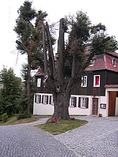
Linden trees
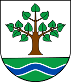
Before the village was founded, Sorbs who had a special relationship with oaks and linden trees settled in the area . The residents of Limbach later had a special relationship with linden trees: This is shown by the municipal seal introduced in 1932, which shows a 13-leaved linden tree over a stream.
There were many linden trees in the village because it was customary for the eldest son to plant a tree at his wedding. A particularly old linden tree stands in front of the rectory. According to tradition, it was planted by Karl Lohse in 1849 as an atonement tree. Karl was the son of the cantor and teacher Gottlob Lohse (1809-1852). Karl was a teacher in Netzschkau. In 1848 he spoke on the market square in Treuen and in 1849 took part in the march to Dresden for the Dresden May uprising . Because of this revolutionary activity he was removed from office. In order not to endanger the existence of his siblings, he repented and planted the linden tree at the rectory.
Another remarkable linden tree stood at the intersection of Karl-Marx-Strasse / Pfaffengrüner Strasse / Pfarrberg. Before the farmers had their mares mated, they led them three times around the linden tree so that the fertility of the linden tree would be transferred to the mares.
History to the present
Until the 19th century, the manor over Limbach was partly owned by the Christgrün manor and the Limbach manor, mentioned in 1394. The manor Limbach in turn belonged to the Elsterberg lordship , which was incorporated into the Plauen office in the 16th century .
Until 1856, Limbach belonged to the Electoral Saxon or Royal Saxon Office of Plauen . In 1856 the place was affiliated with the Treuen court office and in 1875 with the Auerbach administration . As a result of the first district reform in the GDR , the municipality of Limbach became part of the Plauen district in 1950 , but was incorporated into the Reichenbach district in the Chemnitz district (renamed Karl-Marx-Stadt district in 1953 ) through the second district reform in the GDR in 1952 from 1990 onwards as the Saxon district of Reichenbach and merged into the Vogtland district in 1996.
Incorporations
| Former parish | Date of incorporation | annotation |
|---|---|---|
| Buchwald with lower book forest | April 1, 1974 | |
| Lauschgrün | January 1, 1994 | |
| Mill wall | was created around 1816 in the Limbacher Flur | |
| Reimersgrün | January 1, 1994 |
Population development
Development of the population ( December 31 ) :
|
|
|
politics
Municipal council
- FWVL : 9
- CDU : 1
Since the municipal council election on May 26, 2019 , the 10 seats of the municipal council have been distributed among the individual groups as follows:
- Free Voters' Association Limbach (FWVL): 9 seats
- CDU : 1 seat
mayor
Bernd Damisch was re-elected in July 2015.
Culture and sights
Museums
- Alum factory Mühlwand
- Vogtland Gold Museum and Natural History Cabinet in Buchwald
Buildings
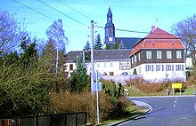
The Limbach church from the 14th century was renovated in the 18th century and received a baroque rectory. The altar was donated by Charles Crodel .
Memorials
Tomb
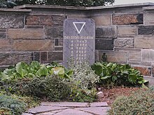
A memorial stone in the local cemetery commemorates seven unknown concentration camp prisoners who were thrown dead from the transport train of a death march in the spring of 1945 and buried here. The train consisted of open wagons and had SS guards; he came from the direction of Plauen and drove in the direction of Reichenbach. The dead were collected along the embankment and taken to the cemetery in a horse-drawn sleigh. According to Walter Wolf, the train had to stop in Reichenbach. The inmates had attached strings to tin cans and tried to use them to get snow from the track bed. According to the eyewitness, there were shootings at the train station.
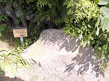
Wheel cross stone
A wheel cross stone ( atonement stone ) is located at the junction between Karl-Marx-Straße and Pestalozzistraße. A wheel cross is carved on both sides of the unworked diabass stone. Ortschronist Alfred Leistner announced in 1963 that he believed it was a memorial stone. A child is said to have been run over at this point in 1740. The following is written in the court book of Treuen: Kauf- u. Lehnbrief: Jahannen Renigen Erlerin on the house conceded by the Limbach community at Platz 16.10175 ... next to Gottfried Denner's garden not far from the village ++ pond until a child was previously killed by the stone ...
Economy and Infrastructure
traffic
The Limbach (Vogtl) stop is on the Leipzig – Hof railway line ( Saxony-Franconia mainline ) and is served by the Vogtlandbahn in local transport . Between 1903 and 1966 the district of Mühlwand had a stop on the Lengenfeld – Göltzschtalbrücke railway line .
The now downgraded, former federal highway 173 leads through the districts of Lauschgrün and Buchwald .
Sons and daughters of the church
- Gerd Bonk (1951-2014), weightlifter
literature
- Richard Steche : Limbach. In: Descriptive representation of the older architectural and art monuments of the Kingdom of Saxony. 9th booklet: Auerbach District Authority . CC Meinhold, Dresden 1888, p. 9.
Web links
- private homepage
- Limbach in the Digital Historical Directory of Saxony
- School friends Limbach 1941–1949
Individual evidence
- ↑ Population of the Free State of Saxony by municipalities on December 31, 2019 ( help on this ).
- ↑ Festival magazine Schul- und Heimatfest 1930, p. 12.
- ^ History of the town and castle Elsterberg i. V .; 3rd vol .; by Paul Beierlein; Dresden; 1934; P. 11 and p. 444-446.
- ↑ Festival magazine Schul- und Heimatfest 1930, p. 14.
- ↑ Historical place directory of Saxony p.432; Limbach (4) .
- ↑ Netzschkauer Stadt - Anzeiger Mar 1997 p. 18; The parish linden tree.
- ↑ Netzschkauer Stadt - Anzeiger June 1997 p. 17; Alfred Leistner.
- ↑ The Christgrün manor at www.sachsens-schloesser.de
- ↑ The Limbach Manor at www.sachsens-schloesser.de
- ^ Karlheinz Blaschke , Uwe Ulrich Jäschke : Kursächsischer Ämteratlas. Leipzig 2009, ISBN 978-3-937386-14-0 ; P. 76 f.
- ^ The Auerbach administration in the municipality register 1900
- ↑ Results of the 2014 municipal council elections
- ↑ https://www.statistik.sachsen.de/wpr_alt/pkg_s10_bmlr.prc_erg_bm_a?p_bz_bzid=BM151&p_ebene=GE&p_ort=14523190
- ↑ Website of the alum works Mühlwand
- ^ Website of the Vogtland Gold Museum in Buchwald
- ↑ www.vogtlandkreis.de ( page no longer available , search in web archives ) Info: The link was automatically marked as defective. Please check the link according to the instructions and then remove this notice.
- ↑ Entry on the Treuen court register (1737-1761), after the entry on the Limbacher Radkreuzstein on www.suehnekreuz.de. Retrieved May 10, 2011 .


