
Dump hammer
| coat of arms | Germany map | |
|---|---|---|

|
Coordinates: 50 ° 26 ' N , 12 ° 28' E |
|
| Basic data | ||
| State : | Saxony | |
| County : | Vogtland district | |
| Height : | 665 m above sea level NHN | |
| Area : | 56.09 km 2 | |
| Residents: | 3025 (Dec. 31, 2019) | |
| Population density : | 54 inhabitants per km 2 | |
| Postal code : | 08262 | |
| Area code : | 037465 | |
| License plate : | V, AE, OVL, PL, RC | |
| Community key : | 14 5 23 245 | |
| Address of the municipal administration: |
Klingenthaler Strasse 29 08262 Muldenhammer |
|
| Website : | ||
| Mayor : | Jürgen Mann (Free Voters) | |
| Location of the municipality of Muldenhammer in the Vogtland district | ||
  |
||

Muldenhammer is the name of a municipality in the Saxon Vogtlandkreis . It was created on October 1, 2009 through the merger of the previously independent communities of Morgenröthe-Rautenkranz , Tannenbergsthal and Hammerbrücke and has over 3000 inhabitants.
geography
The area of the municipality of Muldenhammer extends in the area of the upper course of the Zwickauer Mulde as well as the Small Pyra and Large Pyra . Large areas of the community are covered by forest, including the Auerbacher Forest . In the western part of the municipality, the relief is characterized by low elevations and flat, undulating depressions. In the east, on the other hand, the valleys cut increasingly deeper, for example at Tannenbergsthal and around Morgenröthe-Rautenkranz. This is where the transition from the Vogtland to the Western Ore Mountains takes place.
The traffic road system is well developed in the western municipality. In the regions affected by the mountains, the paved roads run mainly in the large valleys. There is only an active railway connection in the neighboring municipality of Muldenberg. Originally, trains ran here on the Chemnitz – Adorf line . This section of the route has been closed since 1975.
The region has a considerable water retention capacity and is therefore important for the production of drinking water. The Untere Floßgraben, which branches off from the equalization basin in front of the Muldenberg dam , crosses the municipality in the west and is still water-bearing as far as the former Leonhardt sawmill in the Hammerbrücke district. In addition to the extensive forests, there are numerous moor meadows and some former peat cuttings.
Geographical location
Neighboring communities
Muldenhammer has four neighboring communities in the Vogtlandkreis, two in the Ore Mountains and three in the Czech Karlovarský kraj.
.svg)
Community structure
The following districts belong to Muldenhammer:
- Gottesberg
- Hammer bridge
- Hunter green
- Morgenröthe diamond wreath
- Sachsengrund
- Tannenbergsthal with Schneckenstein
history

In November 2008, the formation of a unified municipality was legitimized by local council resolutions in the three municipalities that had formed the joint administrative association Waldgebiet Vogtland since 1994 . A working group with representatives from all three communities decided on the name Muldenhammer in January 2009 to commemorate the earlier iron processing in hammer mills . The design of the coat of arms contains elements of all three places: hammer and mallet represent Hammerbrücke, Frischhaken and rising sun Morgenröthe-Rautenkranz and the fir trees Tannenbergsthal. The watercourse of the trough is also a unifying element. The contract for the formation of the unified community was signed on May 28, 2009 in the Tannenbergsthaler Herrenhaus, which is intended to be the seat of the community administration. This came into force on October 1st. On October 1, 2019, the Muldenhammer community turned 10.
At GDR times of the entertained VEB Maxhütte Unterwellenborn in the district Gottesberg the pioneer camp " Hanno Günther " for the children of his company employees.
politics
Municipal council
Since the municipal council election on May 25, 2014 , the 14 seats of the municipal council have been distributed among the individual groups as follows:
- Free voters Muldenhammer (FWM): 6 seats
- CDU : 4 seats
- LEFT : 2 seats
- Voters' association "René Pöhland" (WV RP): 2 seats
There are currently only 13 seats in the municipal council, as one of the WV René Pöhland seats has been vacant since 2014.
mayor
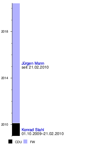
The previous mayor of Morgenröthe-Rautenkranz, Konrad Stahl, was appointed as the municipal administrator. In the election for mayor on February 21, 2010, Jürgen Mann prevailed with 50.2% of the votes against Stahl (48.2%).
Jürgen Mann was confirmed as mayor on February 5, 2017. Election result: Mann, Jürgen (FWM) 61.4%; Standke, René (AfD) 8.8%; Harmful, Wolfgang (Harmful) 29.8%
Youth initiative for Muldenhammer
In September 2019, the municipal council in Muldenhammer cleared the way for the establishment of the youth initiative Jugend für Muldenhammer , which aims to enable children and young people to participate in local politics, which corresponds to Paragraph 47a of the Saxon municipal code, according to which the municipalities in Saxony are children and young people Provide opportunities to be involved in community projects that affect them.
coat of arms
Blazon : “In silver a continuous, single-arched, black-jointed red stone bridge, growing out of it two green fir trees disappearing into the outer edge, in between in silver surrounded by an oval green diamond wreath crossed a black fresh hook, hammer and mallet over a rising red sun with alternating straight and flamed rays, three black waves below. "
The coat of arms was designed in 2009 by the Magdeburg municipal heraldist Jörg Mantzsch .

Hammer bridge

Morgenröthe diamond wreath

Tannenbergsthal


Community partnerships
The places that make up the Muldenhammer community today have partnerships with the following communities:
- Tannenbergsthal with the community of Empfingen
- Morgenröthe-Rautenkranz with the town of Alpirsbach
- Hammerbrücke with the municipality of Loßburg and with the municipality of Harta (Hungary)
All partner communities except Harta are in the Freudenstadt district of Baden-Württemberg.
Attractions
Museums and technical monuments

- German space exhibition in Morgenröthe-Rautenkranz
- Morgenröthe-Rautenkranz home parlor
- historic blast furnace Pollersberg in Morgenröthe
- Tannenberg mine for visitors
- Vogtland-Bohemian Mineral Center Schneckenstein
- Manor house in Tannenbergsthal
Natural monuments
- Snail stone with the well-known topaz deposit ,
- There is an educational moor trail in the nature reserves Am alten Floßgraben and Muldenwiesen .
- Lehmgrubenweg nature trail
- Radium source at Thierberg ,
Sons and daughters of the church

- Sigmund Jähn (1937–2019), fighter pilot , cosmonaut and major general of the East German NVA . In 1978 he was the first German in space .
Web links
Individual evidence
- ↑ Population of the Free State of Saxony by municipalities on December 31, 2019 ( help on this ).
- ↑ StBA: Area changes from January 2nd to December 31st, 2009
- ↑ Free Press, local edition of the Upper Vogtland of November 28, 2008: "Small states must get out of their heads"
- ↑ Freie Presse, local edition Upper Vogtland of November 29, 2008: Knappes Yes for a common path - Hammerbrücke municipal council for a unified community
- ↑ Freie Presse, local edition of Upper Vogtland from January 9, 2009: Forest area: Muldenhammer as a new name
- ↑ Freie Presse, local edition Upper Vogtland of May 30th, 2009: Contract for Muldenhammer is in place - unitary community in the forest area comes into force on October 1st
- ↑ [1]
- ^ Website of the Muldenhammer community - community partnerships
- ↑ Nature and Environment Center Vogtland eV: Moor trail . on www.nuz-vogtland.de
- ↑ Muldenhammer municipality: Hammerbrücke . at www.muldenhammer.com
Adorf / Vogtl. | Auerbach / Vogtl. | Bad Brambach | Bad Elster | Mountains | Bösenbrunn | Eichigt | Ellefeld | Elsterberg | Falkenstein / Vogtl. | Grünbach | Heinsdorfergrund | Klingenthal | Lengenfeld | Limbach | Markneukirchen | Mill Valley | Hollow hammer | Netzschkau | Neuensalz | Neumark | Neustadt / Vogtl. | Oelsnitz / Vogtl. | Pausa-Mühltroff | Plauen | Pöhl | Reichenbach im Vogtland | Rodewisch | Rosenbach / Vogtl. | Schöneck / Vogtl. | Steinberg | Theuma | Tirpersdorf | Faithful | Triebel / Vogtl. | Weischlitz | Who's there
Gottesberg | Hammer Bridge | Hunter green | Morgenröthe-Rautenkranz (with Morgenröthe and Rautenkranz) | Sachsengrund | Snail stone | Tannenbergsthal