Bublava
| Bublava | ||||
|---|---|---|---|---|
|
||||
| Basic data | ||||
| State : |
|
|||
| Region : | Karlovarský kraj | |||
| District : | Sokolov | |||
| Area : | 614.9832 ha | |||
| Geographic location : | 50 ° 22 ' N , 12 ° 30' E | |||
| Height: | 735 m nm | |||
| Residents : | 404 (Jan. 1, 2019) | |||
| Postal code : | 357 22 | |||
| License plate : | K | |||
| structure | ||||
| Status: | local community | |||
| Districts: | 1 | |||
| administration | ||||
| Mayor : | Igor Jirsík (as of 2018) | |||
| Address: | Bublava 389 358 01 Kraslice |
|||
| Municipality number: | 560308 | |||
| Website : | www.obecbublava.cz | |||
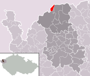
| Location of Bublava in the Sokolov district | ||||

|
||||
Bublava ( German Schwaderbach ) is a municipality in Karlovarský kraj (Karlsbader Region) in the Czech Republic .
geography
Geographical location
The place is in the western Ore Mountains , in the Bohemian Vogtland near the Saxon border in the Okres Sokolov (Falkenau district). In the north rises the 936 m high Kamenáč (Aschberg), the highest point of which is in the municipality. In the south is the Olověný vrch (lead mountain ), 802 m, with a lookout tower and a mountain hut . The Bublavský potok ( Schwaderbach ) flows through the place, which gave the place its name.
Neighboring communities
| Dump hammer | ||
| Klingenthal |

|
Stříbrná (Silberbach) |
| Kraslice (Graslitz) |
Direct neighbors of Bublava are in the south Kraslice (Graslitz) with the district Tisová (Eibenberg) and in the southeast Stříbrná (Silberbach). In the west, across the border with Saxony, is Klingenthal in the Vogtlandkreis .
history
The first documentary mention of the village, which was founded as a charcoal settlement, dates back to 1601. Later, mining formed the economic basis for the inhabitants of the place. After its decline, the cotton spinning mill moved into Schwaderbach with numerous house weavers. An economic boom after 1870 let the number of inhabitants increase. Many of them found employment in the manufacture of musical instruments in Graslitz or in neighboring Klingenthal. With the beginning of the twentieth century tourism developed. Winter sports in particular attracted numerous visitors. The village, which had previously belonged to Graslitz, received a new church in 1883, but was not parished out by Graslitz until 1908.
After the Munich Agreement , the place was added to the German Reich and until 1945 belonged to the Graslitz district .
The population decreased drastically due to the expulsion of the German population after the end of the Second World War.
Population development
|
|
|
Culture and sights
- Olověný vrch (lead mountain )
- War memorial
- Monument to the victims of fascism
economy
Bublava is best known today for its ski and snowboard area on the Olověný vrch (lead mountain).
In 1999 the municipality commissioned the establishment of a leisure center called "Aquapark". Construction began, but was never completed due to the suspension of state subsidy payments. Today the property stands as an investment ruin in the village and causes Bublava great financial problems because of open demands from the construction company.
Web links
Individual evidence
- ↑ http://www.uir.cz/obec/560308/Bublava
- ↑ Český statistický úřad - The population of the Czech municipalities as of January 1, 2019 (PDF; 7.4 MiB)
- ↑ Historický lexikon obcí České republiky - 1869-2015. Český statistický úřad, December 18, 2015, accessed on February 14, 2016 (Czech).
- ↑ Article about the trial before the Sokolov District Court at http://aktualne.centrum.cz , accessed on May 9, 2010


