
Šindelová
| Šindelová | |||||
|---|---|---|---|---|---|
|
|||||
| Basic data | |||||
| State : |
|
||||
| Region : | Karlovarský kraj | ||||
| District : | Sokolov | ||||
| Area : | 3832.9806 ha | ||||
| Geographic location : | 50 ° 19 ' N , 12 ° 36' E | ||||
| Height: | 650 m nm | ||||
| Residents : | 302 (Jan. 1, 2019) | ||||
| Postal code : | 357 06 | ||||
| License plate : | K | ||||
| traffic | |||||
| Street: | Kraslice - Nejdek | ||||
| Next international airport : | Karlovy Vary Airport | ||||
| structure | |||||
| Status: | local community | ||||
| Districts: | 3 | ||||
| administration | |||||
| Mayor : | Jaroslav Benda (as of 2018) | ||||
| Address: | Šindelová 93 358 01 Kraslice |
||||
| Municipality number: | 560677 | ||||
| Website : | www.sindelova.cz | ||||
| Location of Šindelová in the Sokolov district | |||||

|
|||||


Šindelová ( German Schindlwald ) is a municipality in Karlovarský kraj in the Czech Republic .
geography
Geographical location
Šindelová is located in the Bohemian part of the Western Ore Mountains eight kilometers east of Kraslice and belongs to the Okres Sokolov . The location extends in the valley basin of the Rotava stream ( Rothau ). To the south-east is the Tajch pond . To the northeast rise the Ptačí hora ( Hüttenberg , 826 m) and the Vřesovec (781 m), in the northwest lies the Komáří vrch ( Mukenbühl , 951 m). In the south, by the Skřiváň ( Zellersbach ) stream, there is the favorite hunting lodge .
Community structure
The community Šindelová consists of the districts Krásná Lípa ( Schönlind ), Obora ( Hochgarth ) and Šindelová ( Schindlwald ). Basic settlement units are Krásná Lípa, Milíře ( Kohling ), Obora, Ptačí ( bird village or Vogldorf ), Šindelová and U Rybníka ( pond houses ). In addition, the Břidlová ( slate huts ) and Javořina ( maple forest ) deserts are located in the municipality .
The municipality is divided into the cadastral districts of Krásná Lípa u Šindelové, Milíře u Šindelové, Obora u Šindelové, Ptačí and Šindelová.
Neighboring communities
| Stříbrná (Silberbach) | Přebuz (early penance) | Vysoká Pec (blast furnace near Neudek) |
| Rotava (Rothau) |
.svg)
|
Nejdek (Neudek) |
| Jindřichovice (Heinrichsgrün) |
Direct neighbors are Krásná Lípa and Přebuz in the north, Rudné and Vysoká Pec in the northeast, Bernov, Nejdek and Lesík in the east, Poušť and Hradecká in the southeast, Heřmanov and Jindřichovice in the south, Dolní Rotava and Rotava in the southwest, Obora and Sklená in the west Nová Ves in the northwest.
history
The place was mentioned for the first time in 1480 in the course of the establishment of a watch festival "Hradiště" to protect the Zinnstrasse between Frühbuss and Heinrichsgrün . Around 1512, the first six houses were built below the Hradiště Fortress. In 1520 Hradiště near Schönlind was designated as a settlement.
In 1525 the silts from Heinrichsgrün bought Schönlind and Hradiště. They were followed by the Knights of Globen and, from 1589, again by the Schlicken. During this time the village was given the name Schindlwald. In 1561 three hammers and a smelter were operated in Schindlwald. In 1606 a mill was built on the Rothaubach. After the Thirty Years' War , the Schlick family's property was confiscated and the subjects recatholized. Between 1646 and 1651, the Ziegner family of glassmakers founded a glassworks in Schindlwand, and at the same time the Schug family founded another in Vogeldorf. She later started producing colored glass.
The imperial general Otto von Nostitz bought the dominions Graslitz and Heinrichsgrün from 1678 to 1680 . In 1690 a parish school was established in Schönlind, which the children from Vogeldorf, Kohling, Schindlwald and Unter Hochgarth also attended. Around 1700 the residents lived mainly from logging, the manufacture of wooden goods; especially the clapboard makers had a good reputation far and wide. In 1728, the vicar vicar Daniel Joseph Mayer von Mayern visited the parish of Schönlind, three years later he introduced the cultivation of potatoes in the area for the first time in Austria .
In 1735 two more melting furnaces and six hammers were built in the village. During this time lace was also introduced.
Franz Anton von Nostitz-Rieneck had the hunting lodge “Mes idées” built for his wife Maria Elisabeth in 1769. Around 1820 the new settlements Stallerhäuser, Güntherhäuser and Anschhäuser were established. In 1836 the construction of the largest ironworks in the district began with a blast furnace, three large hammers, a tinning shop, a foundry and a rolling mill. Three mill wheels and the largest steam engine in Austria at the time were used to drive it. Two world patents were used for tinning and engraving.
After the abolition of patrimonial Schindlwald formed a community in the Graslitz district from 1850 . The Ober Hochgarth and Schieferhütten settlements were built around 1850. Knöpfmacher settled in the mill houses. In 1855 the Kohling settlement was established. Cheese was made in full angle. In 1880 the fourth school opened in Schindlwald; the Ahornswald settlement was created. From 1910 the municipality belonged to the Neudek district and had 693 inhabitants. In 1909 the ironworks in Schindlwald became part of the newly founded company " Eisenwerke AG Rothau-Neudek ", which employed more than 1000 people in its plants in Schindlwald, Rothau and Neudek and produced around 100,000 t of iron per year. The company was also a leader in sheet metal production in the Austro-Hungarian monarchy. As a result of the global economic crisis, production was relocated to Karlshütten . The company's collapse in 1931 led to the highest unemployment rate in the area in Czechoslovakia and sparked social unrest. In 1930 the population of Schindlwald was 683.
In 1938 Schindlwald had 575 inhabitants, a total of 3848 people lived in the area of today's municipality. After the Munich Agreement , the community was incorporated into the German Empire and belonged to the Neudek district until 1945 . During the Second World War the production of weapons took place. A satellite camp of the Zwodau concentration camp was established in Schindlwald in 1942 and housed 75 women. After the end of the Second World War, Schindlwald returned to Czechoslovakia and, starting from Schönlind, the Germans were gradually expelled. In 1945 the von Nostitz family was expropriated. The rolling mills were partially dismantled and taken to Slovakia. In 1948 the name was changed to Šindelová . In 1950 the parish came back to Okres Kraslice and since 1961 it has belonged to Okres Sokolov. 1950 Břidlová, Javořina, Krásná Lípa, Milíře, Obora and Ptačí were incorporated. In the following years most of the small settlements in the municipality were abandoned.
Development of the population
|
|
|
Culture and sights
Buildings
- Jagdschlösschen "Favorit" with larch avenue. Erwein von Nostitz-Rieneck had the hunting lodge "Mes idées" built for Franz Anton von Nostitz-Rieneck in 1769 removed. In its place he had the neo-baroque castle "Favorit" built between 1904 and 1906. The guests of the Nostitz family at the castle included u. a. Johann Wolfgang von Goethe , who celebrated his birthday there in 1792, the educator of the Nostitz children Jan Evangelista Purkyně , King Alfons XIII. , Empress Elisabeth and George S. Patton .
- Remains of a blast furnace from 1836
Green spaces and recreation
- Recreation area at the Tajch pond
- Kamenný hřib ( stone mushroom ) natural monument
gallery

Hunting lodge "Favorit" Šindelová

On the Tagus in Šindelová
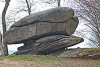
Kamenný hřib natural monument

Remains of the old blast furnace (status 2010)
.jpg)


literature
- Walter Schreiber: Schindlwald - History of a place in the Neudek district, Sudetenland , Wetzlar-Nauborn 1987 (private print)
- Vinzenz Uhl: Castles and palaces of the Ore Mountains and Egertal. Kaaden, 1935.
Web links
Individual evidence
- ↑ http://www.uir.cz/obec/560677/Sindelova
- ↑ Český statistický úřad - The population of the Czech municipalities as of January 1, 2019 (PDF; 7.4 MiB)
- ↑ http://www.uir.cz/casti-obce-obec/560677/Obec-Sindelova
- ↑ http://www.uir.cz/zsj-obec/560677/Obec-Sindelova
- ↑ http://www.uir.cz/katastralni-uzemi-obec/560677/Obec-Sindelova
- ↑ Historický lexikon obcí České republiky - 1869-2015. (PDF) Český statistický úřad, December 18, 2015, accessed on February 15, 2016 (Czech).
- ↑ Šindelová - blast furnace , accessed on October 9, 2015