Těšovice
| Těšovice | ||||
|---|---|---|---|---|
|
||||
| Basic data | ||||
| State : |
|
|||
| Region : | Karlovarský kraj | |||
| District : | Sokolov | |||
| Area : | 118.6967 ha | |||
| Geographic location : | 50 ° 11 ' N , 12 ° 41' E | |||
| Height: | 402 m nm | |||
| Residents : | 249 (Jan. 1, 2019) | |||
| Postal code : | 356 05 | |||
| License plate : | K | |||
| traffic | ||||
| Street: | Sokolov - Loket | |||
| Railway connection: | Chomutov – Cheb | |||
| Next international airport : | Karlovy Vary Airport | |||
| structure | ||||
| Status: | local community | |||
| Districts: | 1 | |||
| administration | ||||
| Mayor : | Josef Radek (as of 2019) | |||
| Address: | Tovární 21 356 01 Sokolov 1 |
|||
| Municipality number: | 579360 | |||
| Website : | www.obectesovice.cz | |||
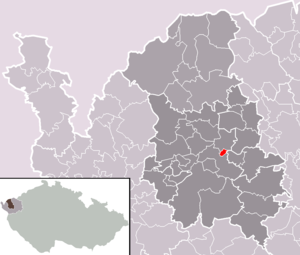
| Location of Těšovice in the Sokolov district | ||||

|
||||
Těšovice (German Teschwitz ) is a municipality in the Czech Republic . It is located on the eastern outskirts of Sokolov and belongs to the Okres Sokolov .
geography
Geographical location
Těšovice is located on the right bank of the Eger in the Falkenau basin . Těšovický vrch (469 m) rises to the east and Na Hardu ( Hardhöhe ) to the west . The Chomutov – Cheb railway line runs to the left of the river, and the "Královské Poříčí" station is just under a kilometer north of Těšovice. There is a bridge over the Eger between Těšovice and Královské Poříčí. East the town of State Road 6 / is E 48 / 49 bypass.
Community structure
No districts are shown for the municipality of Těšovice.
Neighboring communities
Neighboring towns are Královské Poříčí in the north, Horní Pískovec and Nové Sedlo in the northeast, Staré Sedlo in the east, Hrušková and Vítkov in the southeast, Ovčárna in the south and Sokolov in the west.
history
Teschwitz was first mentioned in a document in 1454. The place was part of the Falkenau rule . In the middle of the 19th century, between Teschwitz and Altsattl, the mining entrepreneur Johann David Starck began mining lignite and pyrites. He had a mineral plant built not far from the pits.
His son Johann Anton Starck had the hereditary tunnel of St. Anthony driven to further develop the coal deposits . At three kilometers, the longest historical tunnel in the Falkenau coalfield drained the pits from Teschwitz to Unter Reichenau in the Eger .
After the abolition of patrimonial Teschwitz formed from 1850 a district of the municipality Wudingrün in the district of Falkenau . In 1878 the municipality of Teschwitz was established with the Berghöfe district. In 1885 the Czech name Těšovice became the second official place name. In 1900 Teschwitz consisted of 21 houses and had 112 inhabitants. The village was parish to the church of St. Jakobus in Falkenau . In the 20th century the place grew rapidly.
In 1930 the community had 538 inhabitants, in 1939 there were only 374 after the evacuation of the Czechs. According to the Munich Agreement , the community of Unter Reichenau was incorporated into the German Reich and until 1945 belonged to the Falkenau district . After the end of the Second World War, the place came back to Czechoslovakia and the expulsion of the Germans began.
On January 1, 1961, Těšovice was incorporated into Sokolov . During this period the village acquired the character of a suburb of Sokolov. Around 350 garages were built in the corridors of Těšovice. The community has existed again since the beginning of 1992. Jiří Halberštát has been mayor since the village was rebuilt.
Culture and sights
- "Na Hardu" ( Hardhöhe ) hill with a lookout tower. The 18 m high tower with a half-timbered tower was built in 1907. After the wooden viewing barrier was torn down, a 5 m high figure of Christ cast from bronze by Tony Schönecker was placed on the tower. This was melted down during the Second World War. After the reconstruction, the tower was given its original shape.
- Stone cross

