Aschberg (Vogtland)
| Aschberg / Kamenáč | ||
|---|---|---|
|
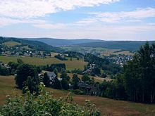
Not on the summit: The "Otto Hermann Böhm" observation tower is on the German side |
||
| height | 936 m above sea level NHN | |
| location | Free State of Saxony , Germany / Czech Republic | |
| Mountains | Ore Mountains | |
| Coordinates | 50 ° 23 '23 " N , 12 ° 30' 32" E | |
|
|
||
| particularities | Otto Hermann Böhm Tower ( AT ) | |
The Aschberg ( Czech Kamenáč ) is a 936 m high mountain in the Saxon - Czech border area near Klingenthal ( Sachsenberg-Georgenthal district ) in Vogtland , the summit of which is in the Czech Republic. The limit is at an altitude of 917 m .
Location and surroundings

There is a lookout tower on the German side near the summit and a youth hostel right next to it . The Aschberg summit plateau is inhabited on the Saxon side. The scattered houses are called Aschbergsiedlung . Originally these were mountain farmhouses.
There is also a transmission mast on the Aschberg . It emits the following frequencies:
- VHF 93.7 MHz ( MDR 1 Radio Sachsen) - power: 0.2 kW
- VHF 98.4 MHz ( MDR culture) - power: 0.2 kW
- VHF 103.5 MHz ( Vogtlandradio ) - power: 0.05 kW
The summit point is on the Czech side and consists of a small rock cliff that supports a granite column of the Royal Saxon Triangulation with a square cross-section . It is station 24 (1st order). It is only of historical importance. There are other cliffs not far from the summit, the most famous of which is the Tři skálky rock group.
On the Aschberg there is a ski slope and the ridge trail , on which you can ski via Mühlleithen to Schöneck or via Carlsfeld to Johanngeorgenstadt .
history
Together with miners and hammer smiths, some glassmakers also came to the western Ore Mountains and began to process the quartz that was to be found in several strands, including on the Aschberg. The vast forests, which had never been used before, provided them with enough wood for the smelting furnaces and for "ashing", the extraction of potash from charcoal .
Observation tower
The 31.91 m high observation tower, named after Otto Hermann Böhm , offers a wide view of the Bohemian Ore Mountains and the Elster Mountains from its 26.64 m high platform . To the east the view extends to the Fichtelberg and the Klínovec ( Keilberg ), to the south to the Imperial and Bohemian Forests . As early as 1913, the tower's namesake founded a tower construction association in order to build a lookout tower on the Saxon side of the Aschberg, based on an idea developed in 1894. For various reasons, however, the plans could not be implemented and were ultimately given up entirely in favor of the Aschberg Youth Hostel, which was built on the mountain in 1929 . The idea was only taken up again in the 1990s and finally implemented in 1999. The operator of the tower, whose viewing platform can be reached via 154 steps, is VSC Klingenthal eV
Paths to the summit
- From the car park at the B 283 in Mühlleithen the blue-marked ridge trail, which in winter leads Kammloipe is used towards Aschberg. Not far from the state border, follow the red marked path coming from Morgenröthe-Rautenkranz to the youth hostel and the observation tower (approx. 3 km).
- From Stříbrná you can use the green marked hiking trail to the Filip guest house, from there the red marked trail continues to the sports hotel in the center of Bublava . Then follow the yellow marked path up to the summit (approx. 5 km).
- From Klingenthal, a narrow road leads directly to the Aschberg plateau.
The Eisenach – Budapest mountain hiking trail runs along the red marked path over the Aschberg.
literature
- Reinhart Heppner / Jörg Brückner / Helmut Schmidt: Saxon-Bohemian panoramic mountains of the western Ore Mountains in words and pictures with tourist information. Horb am Neckar 2000, pp. 15-17.
- Aschberg. In: The mining landscape of Schneeberg and Eibenstock (= values of the German homeland . Volume 11). 1st edition. Akademie Verlag, Berlin 1967, p. 171.
- Klingenthal. In: The Upper Vogtland (= values of our homeland . Volume 26). 1st edition. Akademie Verlag, Berlin 1976, pp. 90-93.
Web links
Individual evidence
- ↑ Map services of the Federal Agency for Nature Conservation ( information )
- ↑ Description on the Klingenthal.de website , accessed on May 2, 2019


