
Mühlleithen (Klingenthal)
|
Mühlleithen
City of Klingenthal
Coordinates: 50 ° 24 ′ 33 ″ N , 12 ° 29 ′ 18 ″ E
|
||
|---|---|---|
| Height : | 858 m | |
| Residents : | 177 | |
| Incorporation : | January 1, 1992 | |
| Postal code : | 08248 | |
| Area code : | 037465 | |
Location of Mühlleithen in Saxony |
||

Mühlleithen is a district of Klingenthal in Vogtland . The place with its district Winselburg was incorporated into Klingenthal on January 1, 1992 and has since formed a district in the sense of a locality . Furthermore, Mühlleithen forms a district of Klingenthal.
Geography and name
Location and name
Mühlleithen is 830–870 meters above sea level between the Kiel (946 meters) and the Aschberg . It is situated in the southeast of the Saxon part of the historic Vogt country , but heard with respect to the natural environment for Westerzgebirge . The federal road 283 runs through Mühlleithen between Tannenbergsthal and Klingenthal not far from the Czech border and about 30 kilometers south of Zwickau . The name Mühlleithens contains the basic word -lithe from the Middle High German word lite , meaning slope and heap . This part of the word is seen in connection with a field name. The Winselburg part of the municipality is located northwest of Mühlleithen. Mühlleithen and Winselburg are part of the Erzgebirge / Vogtland Nature Park .
Neighboring places
| Tannenbergsthal | Gottesberg | |
| Snail stone |
.svg)
|
Sachsengrund |
| Sachsenberg-Georgenthal with stone dobra |
history
Systems that belonged to the tin mine in Gottesberg , north of Mühlleithen, are believed to be the starting point for the creation of Mühlleith. In 1579 Hans Georg Edler von der Planitz, who belonged to the noble family Planitz, who ruled in a number of aristocratic residences, sold this tin mine and the surrounding forests to the Saxon Elector August . Mining was also carried out in the district of Winselburg. The “Neubeschert Glück treasure trove” is documented here around 1823.
A rest and relaxation area for carters, called the Buschhaus, was mentioned in 1790. The Buschhaus was an HO Sporthotel until 1990. The building was built in 1853. The last vacant building was demolished at the end of October 2018. The first settlement in the area of today's Mühlleithen came in 1787. The first houses were built on the so-called mountain , along which a beer trail ran. Carters with wagons and sledges were able to cross the Ore Mountains ridge there. In contrast to the other Klingenthal districts, which were subordinate to the Voigtsberg office , Mühlleithen and Winselburg belonged as the most south-eastern point to the Electoral Saxon and Royal Saxon Office of Plauen until the 19th century . The manor over both places was at the Falkenstein manor .
In the New Alphabetical Directory of Places of the Kingdom of Saxony, published in 1837, Mühlleithen is listed, but there is no information in the columns for the number of residential buildings and residents. In 1838 there was a school in Mühlleithen. The Ecclesiastical Statistical Manual for the Kingdom of Saxony describes it as a secondary school. In 1839 Albert Schiffner called Mühlleithen a “town with municipal rights”. 75 inhabitants in 12 residential buildings are found in the census on December 1, 1843. In the directory of the entire localities of the Kingdom of Saxony from 1857, Mühlleithen is listed together with Brunndöbra with 79 residents in 13 residential buildings. After 1856 Mühlleithen and Winselburg belonged to the Klingenthal court office and from 1875 to the Auerbach administration .
As a result of the second district reform in the GDR , Mühlleithen came to the Klingenthal district in the Chemnitz district in 1952 (renamed the Karl-Marx-Stadt district in 1953 ), which was continued as the Saxon district of Klingenthal in 1990 and became part of the Vogtland district in 1996. On April 1, 1992, Mühlleithen and Winselburg were incorporated into Klingenthal. Today Mühlleithen is one of three Klingenthaler districts in the sense of a locality.
Mühlleithen as a winter sports and relaxation area
Mühlleithen is a winter sports and recreation area that was opened up in the 1920s by regular bus services. There was a winter sports club as early as 1924. The construction of a ski jumping hill in Winselburg (large and small Vogtlandschanze) followed in 1933. In the 1930s, the school functioned as a “model school” for ski training. The international women's ski race, which has been based in Klingenthal / Mühlleithen since 1965, has made Mühlleithen known in the international skiing world. In the 2000s, complex cross-country ski trails with a bridge over the federal highway 283 were built. A short ski slope can be artificially snowed. In addition to holiday apartments and private accommodation, there is the Ferienhotel Mühlleithen.
Development of the population
|
|
|
photos
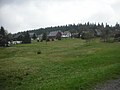
place

Parking lot at the Kiel
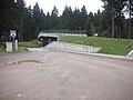
Ski bridge over the B 283

former Hotel Buschhaus

Learning ski slope


literature
- Mühlleiten. In: The eastern Vogtland (= values of the German homeland . Volume 59). 1st edition. Verlag Hermann Böhlaus Successor, Weimar 1998, ISBN 3-7400-0938-1 , p. 219.
- Arthur Müller: Looks into the past of Klingenthal and the surrounding towns of Brunndöbra, Unter- u. Obersachsenberg, Georgenthal, Aschberg, Steindöbra, Mühlleithen with Winselburg, Kottenheide and Zwota. Taking into account the neighboring Bohemian towns. Brückner & Niemann, Leipzig 1897 ( digitized )
Web links
- Mühlleithen (Klingenthal) in the Digital Historical Directory of Saxony
Individual evidence
- ^ Structure of the city of Klingenthal on the website of the Free State of Saxony
- ↑ a b c d e f g h The eastern Vogtland (= values of the German homeland . Volume 59). 1st edition. Verlag Hermann Böhlaus Successor, Weimar 1998, ISBN 3-7400-0938-1 , p. 200.
- ^ Winselburg in the "Handbuch der Geographie", p. 406
- ↑ List of the treasure troves in Vogtland on the website of the Saxon State Ministry
- ↑ https://vogtland-anzeiger.de/vogtland/oberes-vogtland/buschhaus-ist-weg-noch-keine-neuen-plaene-fuer-die-flaeche-artikel10351407 Vogtland-Anzeiger November 1, 2018
- ^ Karlheinz Blaschke , Uwe Ulrich Jäschke : Kursächsischer Ämteratlas. Leipzig 2009, ISBN 978-3-937386-14-0 ; P. 76 f.
- ↑ Mühlleithen and Winselburg in the “Handbuch der Geographie”, pp. 390 and 406
- ^ New alphabetical index of places of the Kingdom of Saxony. Compiled according to official reports by the Central Committee of the statistical association for the Kingdom of Saxony . With the most gracious privilege granted. Verlag der Waltherschen Hofbuchhandlung. Second division M.-Z. Dresden 1837, p. 183 digitized
- ^ Wilhelm Haan : Ecclesiastical statistical manual for the Kingdom of Saxony , printed and available from the publisher Carl Ramming, Dresden 1838, p. 220, digitized
- ^ Albert Schiffner : Handbook of geography, statistics and topography of the Kingdom of Saxony . First delivery, containing the Zwickau district directorate, Friedrich Fleischer, Leipzig 1839, p. 437 digitized
- ^ Announcements of the statistical association for the Kingdom of Saxony, 16th delivery, printed in the printing house of C. Heinrich, Dresden 1844, p. 14 digitized
- ↑ CFT Rudowsky: directory of whole villages of the Kingdom of Saxony, Print by Carl Ramming, Dresden 1857, p 44 Digitalisat
- ^ The Auerbach administration in the municipality register 1900
- ↑ Mühlleithen on gov.genealogy.net
- ^ Internet site for winter sports in the Ore Mountains [1] , accessed on October 25, 2015
- ↑ See Mühlleithen (Klingenthal) in the Digital Historical Directory of Saxony

Klingenthal: Aschberg | Brunndöbra | Döhlerwald | Hat | Klingenthal | Kriegberg | Mittelberg | Quittenbach | Sachsenberg-Georgenthal (with Sachsenberg and Georgenthal) | Stone Dobra | Unterklingenthal
Mühlleiten locality: Mühlleithen | Winselburg
Town Zwota: Oberzwota | Zechenbach | Zwota