
Kiel (mountain)
| Kiel | ||
|---|---|---|
.JPG) Summit of the Kiel as seen from the Schneckensteiner Halde |
||
| height | 943.3 m above sea level NHN | |
| location | Vogtlandkreis , Saxony ( Germany ) | |
| Mountains | Ore Mountains | |
| Coordinates | 50 ° 24 '24 " N , 12 ° 28' 9" E | |
|
||

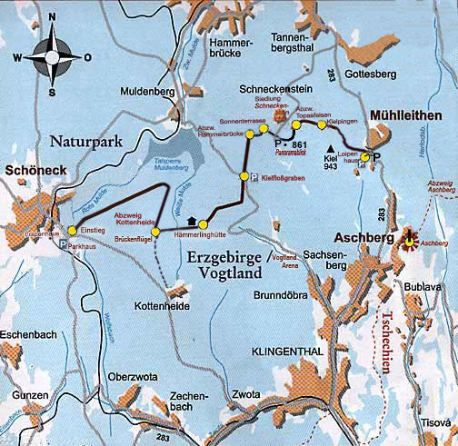
The keel at Klingenthal is 943.3 m above sea level. NHN one of the highest mountains in the Vogtland , stands isolated and is the furthest to the west, over 900 m high, in the Ore Mountains. It is located west of the pass of the federal road 283 near Mühlleithen and is higher than the better known Aschberg ( 936 m above sea level ), which is not far to the south-east. “The mountain shape, triangular in plan” can be seen from afar, because the Kiel towers over the surroundings and because of a radio tower erected on the summit in the 1990s . The keel is wooded up to the summit.
Natural space
The keel is after the natural environment map of axes in the Mesogeochore "Construction and ridge lines around the Auerbergland and Aschberg" and belongs to Mikrogeochore "Kiel-ridge" and is part of the natural park "Ore / Vogt country." The keel lies on the dividing line between the Eibenstock tourmaline granite , which forms the north-east flank, and the "erosion-resistant" Kontakthof mica rock , which makes up the south-west flank.
The keel protrudes from its surroundings in its summit area. It is therefore particularly exposed to the elements on all sides. This has the consequence that it is often immersed in clouds with the result of frequent strong frost formation in winter. This particular climatic exposure affects the growth of the spruce trees. They only reach a low height with branches already formed at a low height. In the summit area, almost all older trees have broken tops, often several. In the Ore Mountains further east, this can only be determined in forests that are 100 to 150 m higher. The lichen hangings characteristic of a cloud forest have decreased compared to earlier.
history
_Winzelburg_und_Bergbauanlagen_Jahr_1792.jpg)
The mountain is already mentioned in the Saxon miles sheets by Friedrich Ludwig Aster from the end of the 18th century as "the Kiel".
The earlier tin mining in the area of the summit still results in tunnel holes and fractures . On sheet 219 of the miles sheets of 1792 there are numerous entries that document the mining activities on the mountain.
In the past, the towns north of the Vogtland and the Ore Mountains such as Zwickau, Leipzig, and even Halle, were supplied with wood from the Vogtland forests, which was transported in particular by rafts on streams and rivers. The "Untere Floßteich" located south-east of the Kiel and the "Kiel Floßgraben", which runs south of the mountain in a westerly direction, are reminiscent of this rafting. This raft ditch was built from 1620 to 1632 and operated from 1633 to 1872. With a length of six kilometers, it has a gradient of one percent. It is a technical monument.
tourism
The keel over the west and north that leads Kammloipe between Johanngeorgenstadt and Schöneck . The self-contained "Kielloipe" runs to the west and south of it near the summit. Many hiking trails also touch the mountain , but none of them lead directly over the summit. One of these hiking trails is the European long-distance hiking trail E3 . It comes from Muldenberg, leads along the “Kiel Floßgraben” on the south side of the Kiel and turns through the Steinbach valley to Mühlleiten. A nature trail called "Mining and Nature Trail" leads around the entire mountain range of the Kiel and touches the Schneckenstein , leads past Mühlleiten, along the raft ditch and reaches the Schneckenstein again. The Kammweg Erzgebirge – Vogtland long-distance hiking trail also leads past Kiel.
traffic
East of the mountain, the federal road 283 coming from Tannenbergsthal leads shortly after Mühlleithen over a pass a good one kilometer away from the summit. To the west of the summit ran the historic "Alte Klingenthaler Straße" at a distance of only about 300 meters and to the south, roughly parallel to the isohypses, just below 900 meters in a west-east curve, the "Schwerdtweg".
literature
- Kiel. In: The eastern Vogtland (= values of the German homeland . Volume 59). 1st edition. Verlag Hermann Böhlaus Successor, Weimar 1998, ISBN 3-7400-0938-1 , pp. 220-221.
See also
Web links
Remarks
Individual evidence
- ↑ a b Map services of the Federal Agency for Nature Conservation ( information )
- ↑ Kiel. In: The eastern Vogtland (= values of the German homeland . Volume 59). 1st edition. Verlag Hermann Böhlaus Successor, Weimar 1998, ISBN 3-7400-0938-1 , p. 220.
- ↑ a b c d Landesvermessungsamt Sachsen (Ed.): Topographic map 1: 25,000 - edition with hiking trails -, sheet 5 - Vogtland, Schöneck, Klingenthal - , 1st edition, Dresden 1996, ISBN 3-86170-900-7
- ↑ a b c d Kiel. In: The eastern Vogtland (= values of the German homeland . Volume 59). 1st edition. Verlag Hermann Böhlaus Successor, Weimar 1998, ISBN 3-7400-0938-1 , p. 221.
- ↑ Natural space map service of the Landschaftsforschungszentrum eV Dresden ( information )
- ↑ Website of the nature park with map, accessed on May 2, 2019
- ↑ a b sheet 219 from 1792 of the Berlin copy of the Sächsische Meilenblätter ( link to map sheet 219 of the Berlin copy in the Dresden State and University Library )
- ^ Landesvermessungsamt Sachsen (Hrsg.): Topographische Karte 1: 25,000 - edition with hiking trails -, sheet 5 - Vogtland, Schöneck, Klingenthal - , 1st edition, Dresden 1996, ISBN 3-86170-900-7 , text on the back of the map
- ↑ Map at Kammloipe.de , accessed on May 5, 2019
- ↑ Description at Kammweg.de , accessed on May 5, 2019