
Hammer bridge
|
Hammer bridge
Community Muldenhammer
|
||
|---|---|---|
 |
||
| Height : | 675 m | |
| Area : | 8.15 km² | |
| Residents : | 1279 (Jan. 1, 2014) | |
| Population density : | 157 inhabitants / km² | |
| Incorporation : | October 1, 2009 | |
| Postal code : | 08262 | |
| Area code : | 037465 | |
Location of Hammerbrücke in Saxony |
||

Hammerbrücke is part of the community Muldenhammer in the Saxon Vogtland district .
geography
Hammerbrücke is located on the upper reaches of the Zwickauer Mulde on the edge of the Western Ore Mountains between Klingenthal in the south and Auerbach in the north and is surrounded on all sides by spruce forests.
Adjacent communities are the cities of Auerbach and Falkenstein , Grünbach and the district of Tannenbergsthal in the Vogtlandkreis.
history
The place was built around 1600 on an iron hammer . A glassworks and a silver mine were added towards the end of the 18th century . Hammerbrücke and Friedrichsgrün belonged to the Plauen office until the 19th century .
On February 1, 1936, Hammerbrücke and Friedrichsgrün merged.
On October 1, 2009, Hammerbrücke and the villages of Morgenröthe-Rautenkranz and Tannenbergsthal merged to form the new community of Muldenhammer .
Development of the population (December 31) :
|
|
|
traffic
The Chemnitz – Aue – Adorf (CA line), which runs through Hammerbrücke, was opened in 1875. With the construction of the Eibenstock dam , this route was interrupted and the through traffic stopped on September 27, 1975. In the remaining section Muldenberg - Schönheide Süd (Wilzschhaus) - Schönheide Ost of the CA line, passenger traffic was discontinued in sections between 1979 and 1982, freight traffic continued until 1996. After the expansion of a switch connection in Muldenberg at the end of the 1990s, the line no longer has any connection to the rest of the DB network and is practically an island route. Since 2008, the Association for the Promotion of Historic West Saxon Railways has been operating tourism and excursion services with a motorized trolley between Schönheide Süd and Hammerbrücke. In 2017 the platform was converted to make it barrier-free.
- gallery

Emmaus Church
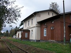
Hammerbrücke station, track view (2016)
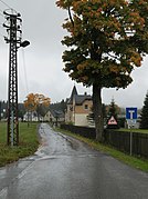
Rissbrücke local area
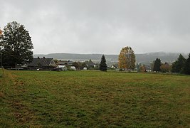
View of Hammerbrücke from Grünbacher Strasse

.jpg)


literature
- The eastern Vogtland (= values of the German homeland . Volume 59). 1st edition. Verlag Hermann Böhlaus Successor, Weimar 1998, ISBN 3-7400-0938-1 , pp. 185-187.
Web links
- Hammerbrücke in the Digital Historical Directory of Saxony
Individual evidence
- ↑ Historical place directory of Saxony
- ^ Report in the Free Press on the establishment of the Muldenhammer community. (No longer available online.) Formerly in the original ; Retrieved June 16, 2009 . ( Page no longer available , search in web archives )
- ↑ Website of the Association for the Promotion of Historic West Saxon Railways , accessed on November 16, 2017

Gottesberg | Hammer Bridge | Hunter green | Morgenröthe-Rautenkranz (with Morgenröthe and Rautenkranz) | Sachsengrund | Snail stone | Tannenbergsthal