
Steinicht

The Steinicht is a steep-walled river valley of the White Elster and is located in the central Vogtland in West Saxony and to a small extent in East Thuringia . It is part of Vogtland Switzerland and the 1,510 hectare nature reserve Kuhberg - Steinicht .
The three kilometer long, up to 70 meters deep V valley between Rentzschmühle and Franzmühle is rightly considered the most impressive valley section of the entire Elsterlauf. The floodplain is barely 50 meters wide in places. The valley walls, often almost vertical, speak for the hardness of the diabase , into which the river has deepened since the beginning of the valley formation at the transition from the Tertiary to the Quaternary.
Climbing area

The Steinicht is considered the largest climbing area in the Vogtland. It was developed in 1834 by Otto Leonhard Heubner, the father of gymnastics from Plauen . Right behind Rentzschmühle you can watch the mountaineers on the Nelkenstein, then the Uhustein. The Orbis Trench is named after St. Urbanus , to whom a chapel was dedicated on the heights. It's a steep, wild and romantic climb up to the Cossengrüner Flur . Here you can find the rocks Dornbusch (Dornstaude), Turm, Teufelskanzel, Hundstein and Peterstein. Fuchstein in front on the left bank of the Elster. The Otterstein is located on the right bank of the Elster.
At the end of the 19th century the eagle owl still nested on the Uhustein . The nature lover and the botanist will find numerous rare plants.
Even with normal water levels in the White Elster, the floods in the area of the Orbisgraben rush with a considerable gradient over the stones in the river bed, and high water marks from 1898 and 1954 on the rock face of the Peterstein are evidence of the forces of nature that unleashed in this valley and led to devastating damage. Here are the old border marks that marked the fishing rights.
Hiking trails
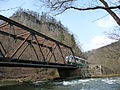
There is no road through the valley. Only the Elstertalbahn and hiking trails accompany the course of the White Elster here. The Reitsteig on the right side of the valley once connected Liebau Castle with Elsterberg Castle . This route is a well-developed path.
For local hikers there is also a path along the rocks on the left side of the valley. To do this, you have to pass the quarry and you also have a short, bad route on the Nelkenstein. This path is easier to walk if you start from the Gippe and walk the path through the Orbisgraben up to Cossengrün. From the Hundsstein you have a view over the valley.
Carnation stone in the Steinicht

General view of the clove stone

Steinicht near Rentzschmühle


Individual evidence
- ↑ Rolf Weber Jocketa, from Greizer Heimatkalender 1965
- ↑ http://dav-plauen-vogtland.de/steinicht.html , accessed in September 2017.
Web links
Coordinates: 50 ° 35 ′ 7 ″ N , 12 ° 9 ′ 44 ″ E