Grove (Langenwetzendorf)
|
grove
Community Langenwetzendorf
Coordinates: 50 ° 42 ′ 28 " N , 12 ° 4 ′ 58" E
|
|
|---|---|
| Height : | 340 m above sea level NHN |
| Area : | 2.72 km² |
| Residents : | 74 (Dec. 31, 2012) |
| Population density : | 27 inhabitants / km² |
| Incorporation : | December 31 2013 |
| Postal code : | 07957 |
| Area code : | 036625 |
|
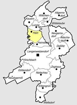
Location of Hain in Langenwetzendorf
|
|
|
Wall temple
|
|
Hain is a district of Langenwetzendorf in the Greiz district in Thuringia .
geography
Hain is located in the Thuringian Slate Mountains near Hohenleuben on the east bank of the Leuba, which was dammed up by the Leubatalsperre .
history
Hain was first mentioned in a document in 1462 . The name indicates a German foundation, which is also confirmed by the townscape and the corridor. The nearby "Temple of Hain" is a rampart built in the 12th or 13th century. In documents from 1577 and 1590 which regulate the ownership of the nearby castle and care Reichenfels , an Abraham von Hayn is mentioned. Later, the place belonged to the domain of the House of Reuss , where it was last under the older line , before it came to Thuringia in 1920. On October 1, 1922, Hain was merged with the neighboring town of Lunzig to form the municipality of Lunzig-Hain. On April 1, 1924, both places became independent again. In the early 1980s, some of the town's buildings were flooded by the damming of the Leuba. On December 31, 2013, Hain became a part of the municipality of Langenwetzendorf . The Leubatal administrative community was dissolved at the same time.
Development of the population
|
|
|
|
- Data source from 1994: Thuringian State Office for Statistics
politics
The last mayor of the community is Olaf Friedrich. He and the six councilors are representatives of the fire department.
Web links
Individual evidence
- ^ Burgruine Reichenfels - A hike through history and landscape, Museum Reichenfels, City of Hohenleuben, probably published around 1992
- ↑ StBA: Area changes from January 1st to December 31st, 2013

