
Thuringian Slate Mountains
| Thuringian Slate Mountains | |
|---|---|
 The Thuringian-Franconian-Vogtland Slate Mountains with the parts of the mountains in the north-west combined as the Thuringian Slate Mountains |
|
 Big farm thinker |
|
| Highest peak | Großer Farmdenkopf ( 868.7 m above sea level ) |
| location | Thuringia, Bavaria (Germany) |
| part of | Thuringian-Franconian low mountain range |
| Classification according to | Federal Institute for Regional Studies; BfN |
| Coordinates | 50 ° 30 ' N , 11 ° 10' E |
| rock | Clay and silica slate , quartzite , greywacke |
| Age of the rock | Neoproterozoic and Paleozoic Era |
| surface | (High plateau) approx. 700 km² |
The Thuringian Slate Mountains , also called Thuringian Slate Mountains , are a maximum of 869 m above sea level. NHN high low mountain range in Thuringia , Germany .
geography
Position and extent
The Thuringian Slate Mountains adjoin the Thuringian Forest to the east and extend as a natural spatial unit to the upper Saale valley in the area of the Saale dams .
As part of a north-west-south-east running low mountain range, the main ridge of the Thuringian Slate Mountains extends between the Thuringian Forest in the north-west and the Franconian Forest in the south-east. Despite the numerous differences between the Thuringian Forest and the main ridge of the Thuringian Slate Mountains, the more well-known term Thuringian Forest is commonly applied to the latter , often in a tourist context . The eastern foothills of the Thuringian Slate Mountains are joined by the Vogtland , which merges further south into the low mountain range Elstergebirge - Ore Mountains running south-west-northeast .
The majority of the mountain area is in the Free State of Thuringia. Only a very small proportion is located in the far north of the Kronach district in the Free State of Bavaria . The mountains are covered by parts of the Thuringian Forest , Franconian Forest and Thuringian Slate Mountains / Obere Saale nature parks .
The Thuringian Slate Mountains are part of an extensive, mostly about 300 m to over 530 m above sea level. NN high, flat, undulating Variscan low mountain range, which gradually flattens out towards the north towards the Thuringian basin . This mountain range comprises very different landscapes, some of which are spatially interlaced: the mountainous high plateau with the Rennsteig heights , the Raanz and the Saalfelder Höhe , the Schwarza and Loquitz valleys, further east the Sormitztal , the gently undulating East Thuringian slate mountains and the upper Saale valley . Large parts of the Thuringian Vogtland, the flat undulating Oberland and its submontane foothills also belong to this mountain range.
On the ridge line , the Rennsteig , in the west of the mountain range, the mountains reach heights between 700 m and over 860 m above sea level. NN . The greatest heights above sea level can be found on an area of approx. 700 km². The highest mountain is the Große Farmdenkopf ( 868.7 m above sea level ) not far from the transition to the Thuringian Forest. The high plateau between the Thuringian Forest and the Franconian Forest covers northward through the catchment areas of the Königseer Rinne , the Schwarza and the Lichte to the Paulinzellaer Buntsandstein-Vorland (Thuringian Basin) and the catchment areas of the Zopte and the Loquitz to the Saale Valley . To the south it covers the upper reaches of the Biber , Werra and Saar to the eastern foothills of the southern Thuringian red sandstone woodland, over the catchment area of the Itz to the Schalkau shell limestone plates and the catchment area of the Steinach to the western Upper Main Jura-Triassic hill country. This plateau region, the main ridge, is also regarded as the actual low mountain range Thuringian Slate Mountains (Thuringian Slate Mountains in the narrower sense).
The main ridge is limited to the east by the so-called Steinacher flexure against the Franconian Forest. The south-west-north-east running flexure separates a relatively narrow strip of Devonian rocks, which still belong to the Thuringian Slate Mountains, from rocks of the Lower Carboniferous , which are already in the Franconian Forest. Since the Devonian rocks in the subsoil offer more favorable conditions for agricultural land use, a narrow strip of clearing runs along their outcrop , which can be clearly seen in aerial photographs. It follows the pass section ("Biel") of a medieval, possibly prehistoric trade route that connects old clearing settlements.


In contrast to the comb Mountains Thuringian Forest high sheet-like ridge with steep slopes and deeply cuts valleys are particularly elongated in the comb area, typical. In the area of the steep-walled valleys of Schwarza and Saale, the height differences between the plateau and the valley floor often reach 300 m and more, which is quite a lot for a low mountain range.


Natural structure
The Thuringian Slate Mountains are roughly divided geomorphologically into the craggy plateau of the main ridge, its domed, domed northeast roofing in the catchment areas of Schwarza and Sormitz and the flat , undulating northeast part. Here, the main ridge at the Steinacher Flexur - and thus still entirely in Thuringia - flows, according to the relief, into the geologically somewhat simpler Franconian Forest, in which the greywacke predominates. In the High Thuringian Slate Mountains themselves, the high proportion of faults in the north-western part, at the interface with the Thuringian Forest, is noticeable. Geologically inconspicuous, on the other hand, is the transition from the Northern High Slate Mountains , ie the slopes north of the Rennsteig, to the Schwarza-Sormitz area , which is more noticeable in the relief. The slopes of the southern high slate mountains roof directly to the southern foreland.
In the manual of the natural division of Germany or in subsequent subdivisions by the BfN , the eastern part, which clearly crosses the Saale and finally even the White Elster , is assigned to a different main unit group than the other two parts, the Thuringian Forest and its south-eastern continuation up to to be summarized to the Fichtelgebirge . The purely inner- Thuringian structure The natural areas of Thuringia of the TLUG in turn summarize all the landscapes mentioned, as far as they are in Thuringia, to form the Thuringian Mountains . In the main subdivisions, however, both subdivisions roughly match.
The parts of the Thuringian Slate Mountains are naturally allocated as follows:
-
(to 39 (= D48) Thuringian-Franconian low mountain range )
- 392 Thuringian-Franconian Slate Mountains
- 392.0 Franconian Forest
- 392.1 Thuringian Slate Mountains in the narrower sense
- 392.10 Southern (High) Thuringian Slate Mountains
- 392.11 Northern (High) Thuringian Slate Mountains
- Schwarza-Sormitz area
- 392 Thuringian-Franconian Slate Mountains
-
(to 41 (= D17) Vogtland )
- 410 East Thuringian-Vogtland plateaus (= East Thuringian Slate Mountains )
- Ronneburg arable and mining area in the extreme northeast of the slate mountain range
- Upper Saale valley between Hirschberg and Saalfeld / Saale
- Plothener pond plate
- 410 East Thuringian-Vogtland plateaus (= East Thuringian Slate Mountains )
Cities

Larger cities in the Thuringian Slate Mountains are Bad Blankenburg and Saalfeld / Saale directly on the northern edge of the mountains, Neuhaus am Rennweg in the ridge, Sonneberg not far from the southern roof at the transition to the Franconian Forest and Bad Lobenstein at the transition to the East Thuringian plateau or to the Vogtland and the Franconian Forest near Blankenstein .
traffic
The long-distance traffic routes Bundesautobahn 73 in the west and Bundesautobahn 9 in the east open up the area. The Thuringian Slate Mountains are crossed by the federal road 281 Eisfeld - Saalfeld, the federal road 85 Kronach - Saalfeld and the federal road 90 Lobenstein - Saalfeld.
On the Hochstadt-Marktzeuln-Probstzella railway line , the main route Munich - Nuremberg - Jena - Halle / Leipzig - Berlin crosses the mountains. Some branch lines lead from the main railways into the Thuringian Slate Mountains, in the northwest the Schwarzatalbahn Rottenbach – Katzhütte, to which the Oberweißbacher Bergbahn is connected, and in the southwest the Eisfeld – Sonneberg railway , which like the adjoining line from Sonneberg to Ernstthal and on to Neuhaus am Rennweg is operated by the Süd-Thüringen-Bahn . In the east of the Thuringian Slate Mountains, the Hockeroda – Unterlemnitz line and the Triptis – Marxgrün line lead into the mountains. The high-speed line Nuremberg – Erfurt runs through the Thuringian slate mountains and crosses under it in the Bleßberg tunnel , but without stopping in the region.
Climate and nature


Due to the crossbar effect of the Thuringian Slate Mountains in relation to the main European weather direction, the climate at high altitudes is very rough. Typical here are, on average, relatively cold, humid summers and long, snowy winters, in which lowest temperatures can be reached that are not necessarily to be expected in a Central European low mountain range at this altitude above sea level. As a result, especially in the ridge areas on the Rennsteig, there is above-average snow reliability for central Germany, which enables winter sports and natural winter sports tourism over a relatively long period of the year. Accordingly, trails are groomed on the hiking trails around the Rennsteig in winter . Above Steinach , the Silbersattel ski arena is Thuringia's largest alpine ski area. The stimulating climate has a high recreational value and a proven therapeutic benefit in the case of respiratory diseases or skin eczema. Many places are state-approved resorts , Masserberg is a climatic health resort . There are also healing caves in the show mines Feengrotten and Morassina (see below).
Neuhaus am Rennweg also holds the German record for the longest continuous foggy period; this lasted 242 hours or 10 days from May 7th to 17th, 1996. The accumulation of high amounts of precipitation resulted in high moors in places . Apart from that, the vegetation dominated by large contiguous spruce mountain forests, which are used for forestry, but as a non-natural monoculture, are susceptible to disease and windbreak. Only on a few steep slopes are there still beech groves , deciduous and mixed forests, more rarely larch , lingonberries , blueberries and wood sorrel . The red foxglove is common on forest paths and clearings . On the mountain meadows made of grass turf and golden oats, there are isolated occurrences of common heather and, more rarely, arnica . Unused field terraces are interspersed with sorrel . The vast forests offer retreats for large populations of hunted large game such as red deer , roe deer and wild boar , for red fox , badger , jay and tawny owl . The red wood ant lives in suitable habitats , the fire salamander uses enclosed forest springs as a hiding place, ponds are inhabited by mountain newts and crested newts. The humid climate offers good conditions for abundant occurrences of various mushrooms, such as chestnut boletus , spruce stone mushroom , common stick sponge , golden yellow coral , frilled mother hen and moss, also Icelandic moss can be found here.
In contrast, the climate in the protected valley areas is significantly milder. They are the habitat of rare plants and animals such as lung gentian , capercaillie , kingfisher and dipper . Brown trout and tench can often be found in the waters . For the wet meadows are horsetail and Trollblume typical. The brown hare is found in the predominantly agricultural open landscape of the undulating plateaus of the East Thuringian slate mountains, the flat valleys and the large clearing islands . Bats, like the great mouse-eared mouse , use abandoned tunnels as wintering quarters, while the little horseshoe bat lives in old village churches. Beautiful old avenues are characteristic of this natural area .
geology


The Thuringian Slate Mountains correspond geologically to the western and northern parts of the Thuringian-Franconian-Vogtland Slate Mountains and are therefore part of the Saxothuringian zone of the Central European Variscides . It extends from the Schwarzburger Sattel in the west over the Ziegenrücker Teilmulde to the Bergaer Sattel in the east. The main ridge (the Thuringian Slate Mountains in the narrower sense) is limited to the southwestern half of the Schwarzburger Saddle.
While the Thuringian Slate Mountains gradually merge into the neighboring regions in almost all directions, it is sharply cut off from the Triassic foreland on the south-western edge by the Franconian Line . The Steinacher flexure forms the border between the main ridge and the Franconian Forest . In this flexure, the Devonian strata of the south-eastern flank of the Schwarzburger saddle dive under the lower carbon of the Teuschnitzer partial hollow.
As the name suggests, the Thuringian Slate Mountains consist largely of slate rocks . Most of these emerged from Paleozoic marine sediments. First and foremost, it is slate that z. Some of them are available as black or alum slate , as well as silica slate . In addition, there are greywacke and sandstones and, to a lesser extent, limestones and some volcanic rocks (including diabase and spilite , as well as various volcanic breccias and tuffites ). The oldest rocks are those of the Katzhütte strata in the core of the Schwarzburger Saddle in the west of the Thuringian Slate Mountains. These rocks were not only folded during the Variscan orogeny around 300 million years ago, but also once during the Cadomian orogeny over 500 million years ago.
Limestone capable of karstification , and thus cave formation, is only ever found in individual, small-scale areas. As a result, there are in fact no caves worth mentioning. The Bleßberg cave is named after an elevation on the southern edge of the main ridge of the slate mountains, but the cave itself is located on the other side of the Franconian line in the lower Muschelkalk (lower Triassic) and is therefore geologically outside the slate mountains.
Geotopes
- Slate mining museum and visitor slate mine in Lehesten ( National Geotope )
- the planks near Saalfeld (National Geotope)

- Bleßberg cave, stalactite cave under the Bleßberg discovered in March 2008 during the construction of the ICE line . Whether it can be made accessible to the public as a show cave is controversial.
- Geological educational trail "Katzhütter Layers" with the geotope "Bärentiegel" near Katzhütte
- Fairy grottoes in the former alum slate mine "Jeremias Glück" in Saalfeld / Saale
- Morassina show mine in the former vitriol mine in Schmiedefeld
- Geotope at the Sorbitztal and nature trail Heinrich Cotta near Sitzendorf
- German Slate Museum and Slate Quarry in Steinach
- Theuern Gold Museum in the village of Theuern near Grümpen
- Slate nature trail Unterloquitz - Probstzella
Water and hydropower

The most important rivers in the Thuringian Slate Mountains are the Saale and its tributaries Schwarza, Loquitz and Sormitz. But the Werra on the one hand and the Itz and Steinach on the other also arise here. As a result, the waters in the Thuringian Slate Mountains have a share in the three major river systems Saale-Elbe, Werra-Weser and Main-Rhine. The Dreistromstein near Siegmundsburg symbolizes this.
In the Saale Valley there are two of the largest dams in Germany, which dam the Hohenwarte and Bleiloch reservoirs . In Schwarzatal is located below the dam Scheibe-Alsbach the Goldisthal Pumped Storage Station , the largest pumped storage power plant in Europe, which opened of 2003.
In the Lichtetal, between Lichte and Unterweißbach , are the Deesbach pre- dam and the Leibis-Lichte dam , which at 102.5 m has the second-highest dam in Germany. Both systems were built between 1981 and 2002 and are used for flood protection and drinking water supply in East Thuringia.
tourism
Tourism has been taking place on a small scale since the mountains were opened up by numerous railway lines since around 1880. The most important health and vacation spots in the region are:
| local community | Overnight stays in 2013 |
Overnight stays in 2001 |
change |
|---|---|---|---|
| Masserberg | 212,361 | 351.208 | −39.5% |
| Saalfeld | 104,814 | 128,485 | −18.4% |
| Bad Lobenstein | 80,953 | 88,222 | −8.2% |
| Bad Blankenburg | 68,287 | 108,435 | -37.0% |
| Neuhaus am Rennweg | 60.183 | 1 | |
| Wurzbach | 43,982 | 91,550 | −52.0% |
| Sonneberg | 38.199 | 36,262 | + 5.3% |
| Saalfelder Höhe | 32,413 | 58,565 | −44.7% |
| Frankenblick | 14,711 | 17,050 | −13.7% |
Mountains (selection)


The mountains of the Thuringian Slate Mountains include - with a height in meters above sea level (NHN):
- Großer Farmdenkopf ( 868.7 m ), Sonneberg district
- Kieferle ( 867.2 m ), Sonneberg district
- Bleßberg ( 866.9 m ), Sonneberg district / Hildburghausen district
- Drought spruce ( 860.7 m ), Sonneberg district
- Eisenberg ( 852.5 m ), Sonneberg district
- Breitenberg ( 844.1 m ), Sonneberg district
- Fellberg ( 842.1 m ), Sonneberg district
- Eselsberg ( 841.5 m ), Hildburghausen district, Thuringian Forest / Thuringian Slate Mountains
- Pappenheimer Berg ( 834.5 m ), Sonneberg district
- High shot ( 824.6 m ), district of Saalfeld-Rudolstadt
- Langer Berg ( 808.6 m ), Ilm district
- Hettstädt ( 808.1 m ), Saalfeld-Rudolstadt district
- Rauhhügel ( 802 m ), Saalfeld-Rudolstadt district
- Roter Berg ( 799.2 m ), Sonneberg district
- Spitzer Berg ( 790.3 m ), Saalfeld-Rudolstadt district
- Grendel ( 787.2 m ), Hildburghausen district
- Meuselbacher Kuppe ( 786.1 m ), district of Saalfeld-Rudolstadt
- Kirchberg (Oberweißbach) ( 784.2 m ), Saalfeld-Rudolstadt district
- Simmersberg ( 780.8 m ), Hildburghausen district, Thuringian Forest / Thuringian Slate Mountains
- Himmelsleiter ( 774.3 m ), Saalfeld-Rudolstadt district
- Töpfersbühl ( 762.6 m ), Saalfeld-Rudolstadt district
- Kirchberg (Reichmannsdorf) ( 725.3 m ), Saalfeld-Rudolstadt district
- Quittelsberg ( 708.8 m ), Saalfeld-Rudolstadt district
- High forest ( 693.6 m ), Ilm district
- Ratzenberg ( 678 m ), Kronach district, Franconian Forest / Thuringian Slate Mountains
- On the heath ( 668 m ), Saalfeld-Rudolstadt district
- Barigauer Höhe ( 664.6 m ), Saalfeld-Rudolstadt district
- Zipptanskuppe ( 656.8 m ), district of Saalfeld-Rudolstadt
- Erbisbühl ( 638 m ), city of Sonneberg
- Talberg ( 600.8 m ), Saalfeld-Rudolstadt district
- Ziegenberg ( 496.6 m ), Saalfeld-Rudolstadt district
→ For these and other mountains see section Thuringian-Franconian Slate Mountains in the article List of Mountains in Thuringia.
Impressions

View from Masserberg to the Barigauer Höhe

Lauscha with its slate-studded and slate-roofed houses

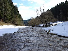
Werra spring near Fehrenbach


.JPG)


Lehesten Slate Mining Museum
The valley of the Breitenbach near Böhlen

Lauenstein Castle and the Dresselstein

View from Simmersberg to Schnett and Waffenrod / Hinterrod , Eckartsberg and Klingeberg
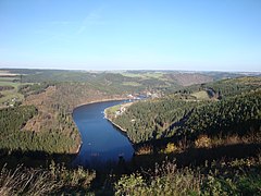
View of the Hohenwarte reservoir between Altenbeuthen and Linkenmühle

Hohenwarte reservoir at the Linkenmühle

Meuselbach-Schwarzmühle and the Viehberg

Observatory in Neufang on the Erbisbühl


See also
literature
- Saalfeld and the Thuringian Slate Mountains (= values of the German homeland . Volume 62). 1st edition. Böhlau, Cologne / Weimar / Vienna 2001, ISBN 978-3-412-10800-7 .
- Adolf Hanle (Ed.): Thuringian Forest and Slate Mountains. Meyers Lexikonverlag, Mannheim a. a. 1992, ISBN 3-411-07191-5 .
- Ernst Kaiser: Thuringian Forest and Slate Mountains. 2. verb. and additional edition. Geographical Cartographic Institute, Gotha 1955, DNB 452294010 .
Web links
- Dietrich Franke: Regional Geology East. Geological online reference work for East Germany with around 2500-page encyclopedia (PDF; 19 MB) and separately downloadable maps and tables
- Thuringian Slate Mountains Nature Park
Remarks
- ↑ The area of 700 km² includes the High Thuringian Slate Mountains (406 km² [1] ) as well as the western part of the Schwarza-Sormitz area that extends approximately to the lower reaches of the Loquitz (a total of 516 km² [2] ), which this area covers to the north .
- ↑ At least the pass section over the mountain ridge was called Biel / Biehl, presumably from the Celtic deity Belenus . The term is preserved as a street name in places. The name “Bühl” of several mountains probably also has this reference. At the transition to the grave field south of the Werra was the Celtic oppidum Steinsburg , a ring wall on the Herrnberg near Siegmundsburg was assigned to the same era ( Hallstatt / Latène period ).
- ^ Name from sheet Coburg; in the manual itself still referred to as "Thuringian Slate Mountains"
- ↑ The division into the Hohes Thuringian Slate Mountains and the Schwarza-Sormitz area is more recent and roughly corresponds to the structure in The Natural Spaces of Thuringia , whereby the Schwarza-Sormitz area does not include the parts mapped on the individual sheets.
Individual evidence
- ↑ Map services of the Federal Agency for Nature Conservation ( information )
- ↑ Grundmann: Saalfeld und das Thüringer Schiefergebirge 2001. The source expresses itself primarily on the geomorphology of the Loquitztal, but points out that the Loquitztal lies in the north-eastern extension of the Steinacher Flexur and the geological and geomorphological conditions there are therefore largely identical to those at the actual Steinacher flexure, d. H. south of the Franconian Forest transverse zone .
- ↑ Hydrogeological map of Thuringia from the Thuringian State Institute for Environment and Geology (PDF; 4.37 MB) ( Even finer maps are available for each district .)
-
^ Walter Hiekel, Frank Fritzlar, Andreas Nöllert and Werner Westhus: The natural spaces of Thuringia . Ed .: Thuringian State Institute for Environment and Geology (TLUG), Thuringian Ministry for Agriculture, Nature Conservation and Environment . 2004, ISSN 0863-2448 . → Natural area map of Thuringia (TLUG) - PDF; 260 kB → Maps for each district (TLUG) - TLUG does not use any code numbers!
- ^ E. Meynen and J. Schmithüsen : Handbook of the natural spatial structure of Germany - Federal Institute for Regional Studies, Remagen / Bad Godesberg 1953–1962 (9 deliveries in 8 books, updated map 1: 1,000,000 with main units 1960)
-
↑ Various authors: Geographical Land Survey: The natural spatial units in single sheets (per map 1: 200,000 and paperback; → maps ) - Federal Institute for Regional Studies, Bad Godesberg 1959–1987; Registration by single sheets due to non-appearance of the sheets Plauen (north) , Plauen (south) and Bayreuth very incomplete!
- Sheet 141: Coburg (H. Späth 1987)
- ↑ Weather records - fog. German Weather Service , accessed on November 20, 2010
- ^ Franke: Regional geology of East Germany . 2012.
- ↑ Arrivals, overnight stays and length of stay of guests in accommodation facilities according to selected municipalities (excluding camping) in Thuringia at statistik.thueringen.de, accessed on August 19, 2019
- ↑ Height control points on the website of the State Office for Surveying and Geoinformation Thuringia , accessed on December 10, 2015