
Leibis-Lichte dam
| Leibis-Lichte dam | |||||||||
|---|---|---|---|---|---|---|---|---|---|
 |
|||||||||
|
|||||||||
|
|||||||||
| Coordinates | 50 ° 36 '3 " N , 11 ° 10' 24" E | ||||||||
| Data on the structure | |||||||||
| Construction time: | 2002-2005 | ||||||||
| Height above valley floor: | 93.5 m | ||||||||
| Height above foundation level : | 102.5 m | ||||||||
| Height of the structure crown: | 444 m above sea level HN | ||||||||
| Building volume: | 620,000 m³ | ||||||||
| Crown length: | 369 m | ||||||||
| Crown width: | 9 m | ||||||||
| Base width: | 80.6 m | ||||||||
| Slope slope on the air side : | 1: 0.78 | ||||||||
| Slope slope on the water side : | perpendicular | ||||||||
| Power plant output: | 1 MW | ||||||||
| Data on the reservoir | |||||||||
| Altitude (at congestion destination ) | 436 m above sea level HN , at high water 441 m above sea level. HN | ||||||||
| Water surface | 106.56 ha | ||||||||
| Reservoir length | 3.6 km | ||||||||
| Storage space | 32.4 million m³ | ||||||||
| Total storage space : | 39.2 million m³ | ||||||||
| Design flood : | 86.5 m³ / s | ||||||||
| Particularities: |
straight axis, vertical water side |
||||||||

The Leibis-Lichte dam (also: Leibis / Lichte) is a dam in the Free State of Thuringia . It is located near Unterweißbach in the Lichtetal in the Thuringian Slate Mountains . It takes its name from the town of Leibis, whose 100 residents were relocated to Neu-Leibis , and the dammed water Lichte , a tributary of the Schwarza . It serves the drinking water supply of East Thuringia and the flood protection . After the flooding began in February 2005, the official inauguration took place on May 12, 2006. The flooding took place until mid-2008. A daily withdrawal of 43,700 m³ of raw water is planned. The Deesbach pre- dam is in front of the dam .
Building
The dam of Leibis-light was as gravity dam from concrete built, as the slate-rock and almost straight valley not provide adequate support for an arch dam would offer. The construction of the dam started in September 2000 after about 20 years of planning and was very controversial. The foundation stone was laid on September 6, 2002. In 2004 it was about half the height of the wall and flooding began in February 2005. The dam is a "large dam" according to ICOLD criteria and will be the last big dam to be built in Germany for a long time. It is the second highest dam in Germany after the Rappbode dam. It was originally supposed to be 107.5 meters high, which would have exceeded the Rappbode dam by 1.5 meters. The cost was 140 million euros.
execution
The underground of the dam is sealed with an injection curtain. The dam itself was built using the so-called block construction method . The size of the 1090 blocks varies considerably. In almost all of them, the height of the blocks is 2.50 m, the width 10 m, and the length varies between 7 and 30 m. These different dimensions result from the position of the respective blocks. Five different types of concrete were used in the building, each with a different composition. 108 blocks were made from the so-called core concrete. These blocks are only surrounded by other blocks. For a further 140 blocks, which are in direct contact with the ground, sole or sole fine concrete was used. The remaining blocks were made from facing concrete. Construction joint concrete was used for the joints.
Building materials
| Characteristic values after 90 days | Core concrete | Facemix sole concrete |
Sole fine concrete | Construction joint concrete |
|---|---|---|---|---|
| Compressive strength in N / mm² | 30.6 | 29.1 | 30.7 | 27.6 |
| Tensile strength in N / mm² | 4.83 | 4.15 | 4.48 | 4.69 |
| Splitting tensile strength in N / mm² | 2.15 | 2.01 | 3.06 | 2.61 |
| Modulus of elasticity (static) in N / mm² | 30.192 | 30,246 | 22,365 | 21.738 |
| Water penetration depth in mm | 40 | 24 | 30th | 25th |
| Solid concrete density in tons / m³ | 2,434 | 2.405 | 2.306 | 2,340 |
| Fresh concrete density in tons / m³ | 2,423 | 2.408 | 2.267 | 2,294 |
Tunnel systems
The Leibis / Lichte dam is supplied or discharged via three tunnels and a connecting structure. All tunnels, with the exception of the culvert system for the Sorbitztal crossing, were drilled with a 38 m long tunneling machine.
| tunnel | length | construction time | diameter | expansion |
|---|---|---|---|---|
| Cat studs | 9,806 m | 1989-1994 | 2.70 m | only partially with shotcrete |
| Lichtestollen I | 3,375 m | 1983-1989 | 2.70 m | only partially with shotcrete |
| Sorbitztal crossing | 220 m | 1989; 2004-05 | 2 × 1000 mm | DN 1000 pipes |
| Lichtestollen II | 7,334 m | 1981-1986 | 2.70 m | only partially with shotcrete |

Cat studs
Water is led through the Katzestollen in a free gradient from the Katzetal west of the dam into the reservoir. The inlet is near the village of Katzhütte , the outlet near the dam. To initiate the water in the tunnel was in the river cat a fortification built. Since the beginning of 2010, advice has been given on solutions to keep the water leaking from the Katzestollen away from the dam so that the towns of Oberweissbach and Cursdorf are no longer in the protection zone.
Lichtestollen I
The raw water of the dam is channeled through Lichtestollen I from the water tower below the dam wall to the Sorbitztal. The tunnel has a gradient of 2.2 per thousand, so that there is a high point in the Sorbitztal. This difference in height is overcome by the water tower on the dam. In the case of direct extraction from the dam, the tunnel should have been designed as a pressure tunnel .
Sorbitztal crossing
The Sorbitztalquerung is the connecting element between the Lichtestollen I and II and crosses under the river Sorbitz . It consists of two 220 meter long pipe culverts, which were built in 1989 and between 2004 and 2005. The two light tunnels are immediately adjacent to both sides of the valley. The variant with two DN 1000 pipes was chosen to ensure security of supply in the event of damage. Normally, however, only one of the two lines is operated. The facility near Rohrbach in the Sorbitztal also houses two gates that allow access to the tunnels in the event of maintenance. They were built from 2004 to 2005.
Lichtestollen II
The Lichtestollen II leads the raw water over a length of 7,334 meters from the Sorbitztal crossing to the Zeigerheim drinking water treatment plant. Like Lichtestollen I, it has a gradient of 2.2 per thousand.
Replacement measures
A total of 33 ecological replacement measures are being carried out to compensate for the negative effects caused by the construction. These include the dismantling of weir systems, the renaturation of rivers, the redesign of 270 hectares of forest, the releasing of 40 capercaillies in the Lichtetal and a wild bed release from the dam to the lower reaches of the river, adapted to the inflow. The latter serves to maintain the high quality habitats in the Schwarzatal . During the construction work, all nature conservation issues were taken care of by ecological construction supervision. In 2006 it was decided that the roadway of the cable crane system would not be dismantled for cost reasons, but would be converted into a biotope.
Approval process
The planning services for the construction of the Leibis-Lichte dam and the connected remote water supply system began as early as the 1970s. This was followed by extensive preparatory work, such as the excavation of the tunnels, the clearing of the building site and the construction of the Deesbach dam.
After the fall of the Wall , the construction of the dam was preceded by a lengthy approval process.
- August 2, 1993: The application for planning approval is submitted.
- 15./21. June 1995: The Thuringian state parliament approves further pursuit of the construction project, but allows the water level to be reduced by five meters.
- August 1999: The Federation for the Environment and Nature Conservation Germany sued against an order for the immediate construction of the dam.
- August 26, 1999: The action against immediate execution is dismissed by the Gera Administrative Court. Since the BUND waives legal remedies, the preparatory measures can begin.
- October 2001: The BUND takes legal action against the plan approval decision .
- October 17, 2001: The lawsuit is dismissed. Nine years after the application for construction was submitted, the final building law now applies.
The village of Leibis

Leibis was a village in what is now the reservoir of the main barrier with transport links to Meura, Unterweißbach, Lichte and Deesbach. It had 100 inhabitants and was right on the Lichte River. Until 1918 the place belonged to the sovereignty of the Principality of Schwarzburg-Rudolstadt .
For reasons of drinking water protection, the buildings were very carefully removed. Even the foundations were removed. A war memorial was preserved. The inhabitants of the village were still relocated to Neu-Leibis near the Mankenbachsmühle below Unterweißbach after the basic permits were issued before reunification , but they received compensation. Most of the residents were resettled as early as 1994, but one resident resisted until mid-1999. Today Leibis is about 90 m below the water level of the reservoir.
Surroundings
The Leibis-Lichte dam has a pre- dam ( Deesbach ) that was completed in 1990. To the north-west of the dam are the site of the former construction site and a visitor pavilion. For reasons of drinking water protection, the dam can only be reached on foot via a steep path from the valley floor, the former construction road, or with the Lichtetalbahn. The construction of the dam had almost no negative effects on the area. Restaurants, holiday apartments and the Lichtetalbahn benefit from the numerous visitors who visit the dam every year. All construction site facilities, except for the most prominent ones such as the concrete loading quay and the construction roads, have been dismantled. The roadway of the cable crane system is still clearly visible on the slope.
Movie
In 2007, the feature film Die Hitzewelle - Nobody can escape was partly shot at the dam.
photos

Dam under construction (December 2004)

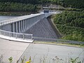
Power plant house (in the wall), stilling basin and valve building

Service building on the dam
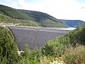
Completed dam in August 2009

Waterside
View from the east
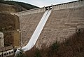
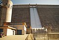
Functional test of the flood relief at the end of the trial jam in April 2010
Functional test of the flood relief in April 2010
Full jam at the end of the trial jam in April 2010

Dam wall (November 1, 2016)

Lake from the top of the wall.


.jpeg)
See also
literature
- Harald Roscher, Thuringian long-distance water supply: Dams and long-distance water supply systems in Thuringia (2006)
Web links
- Page about the Leibis-Lichte dam on the Thuringian long-distance water supply website
- Jörg-Peter Wagner: Mass concretes for the Leibis / Lichte dam. Concrete information 2/3 2004
- Digital hike around the Leibis-Lichte dam (22 spherical panoramas)
Individual evidence
- ↑ Thuringian State Office for Surveying and Geoinformation: http://www.geoproxy.geoportal-th.de/geoclient/. Retrieved July 11, 2017 .
- ↑ Without pre-lock Deesbach
- ↑ Report of the OTZ on the definition of the drinking water protection zone
- ↑ Page on the Leibis-Lichte dam on the Thuringian long-distance water supply website
- ↑ IMDB entry for the film "The Heat Wave"