Zeulenroda district
| Basic data | |
|---|---|
| District of the GDR | Gera |
| County seat | Zeulenroda |
| surface | 263 km² (1989) |
| Residents | 38,594 (1989) |
| Population density | 147 inhabitants / km² (1989) |
| License Plate | N (1953–1990) NT, NU (1974–1990) ZR (1991–1995) |

|
|
| The Zeulenroda district in the Gera district | |
The Zeulenroda district was a district in the Gera district of the GDR . From 1990 to 1994 it existed as the district of Zeulenroda in Thuringia . Today his area is mainly in the district of Greiz in Thuringia. As a result of assignments to the state of Saxony, there are also places in the local Vogtlandkreis that previously belonged to the Zeulenroda district. The seat of the district administration was in Zeulenroda .
geography
location
The district was in the southeast of the Gera district .
Neighboring areas
The Zeulenroda district bordered clockwise in the north, beginning with the Gera-Land , Greiz , Plauen-Land , Schleiz and Pößneck districts .
Natural space
The district was part of the East Thuringian-Vogtland plateau . The highest point in the district was near Pausa in the south (509 m). From here, the plateau made up of slate sank to the north (465 m near Auma) and northeast (412 m near Staitz). The district was crossed by numerous small rivers, which either flowed into the White Elster in the Greiz district or fed the Zeulenroda reservoir or the Weidastausee . They include: B. the Leuba, Triebes, Weida and Auma .
In the circle was the five hectare nature reserve Gütterlitz near Gütterlitz . There was an FDGB vacation home at the Zeulenroda dam .
history

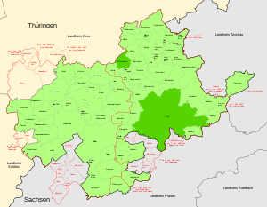
Light green: Greiz district before July 1, 1950
Dark green: from July 1, 1950 to the Greiz district
Status municipality boundaries, state borders and black district boundaries: July 1, 1950
Status red District boundaries: January 1, 1956
The law on the further democratization of the structure and functioning of the state organs in the states in the German Democratic Republic of July 23, 1952 resulted in an extensive district reform in the five remaining states of the GDR . On July 25, 1952, the federal states were dissolved and 14 districts were established. Here traditional circles were dissolved or divided into smaller circles, whereby there were also changes of area beyond the borders of the former five countries. The Zeulenroda district was mainly formed from the Greiz district ( Thuringia ). The district was assigned to the newly formed district of Gera , district town and seat of administration ( council of the district until 1990; then district office ) was Zeulenroda .
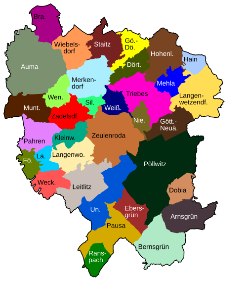
The following 49 municipalities formed the new Zeulenroda district :
- 3 municipalities from the district of Gera :
- Auma , Forstwolfersdorf and Wiebelsdorf ,
- 38 municipalities from the district of Greiz :
- Arnsgrün , Bernsgrün , Brückla , Dobia , Dörtendorf , Heritage Green , Fröbersgrün , Göhren , Götte Village Neuärgerniß , Hain , Hain Berg , Hohenleuben , Kleinwolschendorf , Krölpa , Langenwetzendorf , Langenwolschendorf , Leiningen , Leitlitz , Lunzig , Mehla , Merkendorf , Muntscha , Naitschau , Niederböhmersdorf , Pahren , Pöllwitz , Schönbrunn , Silberfeld , Staitz , Stelzendorf , Triebes , Weckersdorf , Weißendorf , Wellsdorf , Wenigenauma , Wolfshain , Zadelsdorf and Zeulenroda ,
- 7 municipalities from the district of Plauen ( Saxony ):
- Ebersgrün , Linda , Oberreichenau , Pausa , Ranspach , Unterreichenau and Wallengrün ,
- the municipality of Läwitz from the Schleiz district .
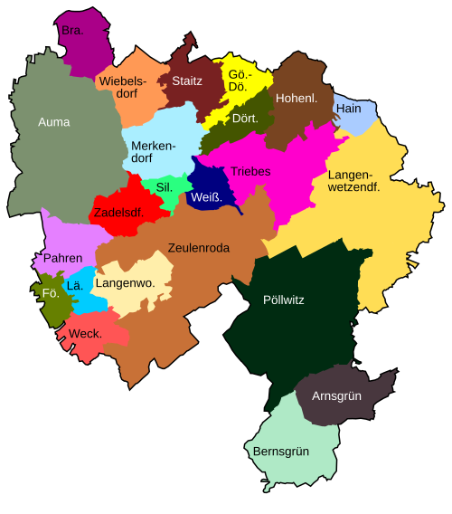
As a result of reclassifications across district boundaries and changes to the municipal area, the number of municipalities fell to 19 when the district was dissolved at the end of June 1994:

- December 4, 1952 Reclassification of Erbengrün , Leiningen , Lunzig , Naitschau and Wellsdorf from the Zeulenroda district to the Greiz district
- December 4, 1952, Forstwolfersdorf was reclassified from the Zeulenroda district to the Gera-Land district
- December 4, 1952 Reclassification of Förthen from the circle Schleiz in the circle Zeulenroda
- December 4, 1952 Fröbersgrün was reclassified from the Zeulenroda district to the Plauen-Land district
- December 4, 1952, Tischendorf was reclassified from the Pößneck district to the Zeulenroda district
- January 1, 1956, Braunsdorf was reclassified from the Pößneck district to the Zeulenroda district
- January 1, 1957 Brückla is incorporated into the town of Hohenleuben
- 1st July 1961 incorporation of Oberreichenau into the town of Pausa / Vogtl.
- January 1, 1970 Schoenbrunn is incorporated into Bernsgrün
- January 1st 1970 incorporation of Wolfshain in Ebersgrün
- March 22, 1970 Incorporation of Wallengrün in Unterreichenau
- January 1st 1974 incorporation of Krölpa in Muntscha
- January 1st, 1974 Stelzendorf is incorporated into Pahren
- January 1, 1974 (Bad) Linda is incorporated into the town of Pausa / Vogtl.
- January 1st 1979 incorporation of Hainsberg in Langenwetzendorf
- 1st January 1979 incorporation of Tischendorf in Braunsdorf
- January 1, 1992 Outsourcing of the Wolfshain district from the Ebersgrün community and incorporation in Pöllwitz
- April 1, 1992 incorporation of Dobia in Pöllwitz
- April 1, 1992 incorporation of Kleinwolschendorf into the town of Zeulenroda
- April 1, 1992 reclassification from Ebersgrün , Ranspach , Unterreichenau and the town of Pausa / Vogtl. in the district of Plauen (Saxony)
- July 1, 1992 incorporation of Göttendorf-Neuärgerniß to Langenwetzendorf
- July 1, 1992 Niederböhmersdorf is incorporated into the town of Zeulenroda
- July 14, 1993 incorporation of Leitlitz into the city of Zeulenroda
- March 8, 1994 Integration of Naitschau, Wellsdorf and Zoghaus (Greiz district) into Langenwetzendorf
- March 25, 1994 Incorporation of Muntscha and Wenigenauma into the city of Auma
- April 6, 1994 Incorporation of Mehla into the city of Triebes
- May 1, 1994 Förthen , Läwitz , Pahren and Weckersdorf are incorporated into the town of Zeulenroda
On May 17, 1990, the district was renamed the Zeulenroda district. On the occasion of the reunification of the two German states, the district of Zeulenroda was assigned to the re-established state of Thuringia by the Land Introduction Act in October 1990 . During the district reform in Thuringia , it was completely absorbed on July 1, 1994 in the district of Greiz .
Population development
|
|
Chairwoman of the district council / district administrator
During the GDR era, the district was led by a district council. It consisted of the chairman, the deputies, the secretary and the department heads. The only freely elected district administrator was Martina Schweinsburg (CDU).
- 1952–1954: J. Rabitzsch
- 1954-1955: H. Cyranek
- 1955-1959: H. Krahnert
- 1959–1963: W. Reichl
- 1963-1964: R. Knorr
- 1964-1965: G. Grau
- 1965–1978: W. Götz
- 1979–1990: H. Hentschel
- 1990–1994: Martina Schweinsburg
economy
The traditional textile industry determined the economic structure of the district. The companies VEB Linen Union and VEB Lace and Clothing were located in Pausa. But textiles were also manufactured in Hohenleuben and Zeulenroda, and textile packaging in Triebes. A parent company of the combine leather processing in Hohenleuben manufactured sports shoes. Furthermore, the porcelain industry, machine tool construction (VEB WEMA), furniture production and rubber processing (VEB Rotpunkt) were important in the district. Hard-paste porcelain electrical fuses were manufactured in Pausa and Auma. In addition, Zeulenroda was of touristic importance because of its location at the dam . There was an FDGB vacation home on the lakeshore.
traffic
Only one major railway line ran through the district from north to south. It led via Weida (Gera district), Triebes, Zeulenroda, Pausa to the Plauen district. Auma was on the Triptis-Lobenstein railway line , which crossed only part of the district in the west. Two trunk roads crossed the district area, the F 2 and the F 94 , both of which came from the southwest (Schleiz).
Population data of cities and municipalities
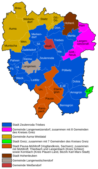
Population overview of all 35 municipalities in the district that came to the re-established state of Thuringia in 1990.
| AGS | local community | Residents | Area (ha) | current affiliation | ||
| 10/03/1990 | December 31, 1990 | local community | district | |||
| 16045010 | Arnsgrün | 373 | 366 | 879 | Zeulenroda-Triebes OT Eubenberg: Greiz |
Greiz |
| 16045020 | Auma , city | 3,313 | 3,294 | 2.013 | Auma-Weidatal | Greiz |
| 16045030 | Amber green | 544 | 540 | 1,151 | Zeulenroda shoot | Greiz |
| 16045040 | Braunsdorf | 281 | 276 | 618 | Auma-Weidatal | Greiz |
| 16045050 | Dobia | 124 | 121 | 411 | Zeulenroda shoot | Greiz |
| 16045060 | Dörtendorf | 211 | 209 | 452 | Zeulenroda shoot | Greiz |
| 16045070 | Boar green | 445 | 446 | 791 | Pausa-Mühltroff OT Wolfshain: Zeulenroda drive |
Vogtland district of Greiz |
| 16045080 | Förthen | 88 | 87 | 301 | Zeulenroda shoot | Greiz |
| 16045090 | Goehren-Döhlen | 121 | 115 | 458 | Auma-Weidatal | Greiz |
| 16045100 | Gottendorf new annoyance | 336 | 339 | 617 | Langenwetzendorf | Greiz |
| 16045110 | grove | 59 | 59 | 272 | Langenwetzendorf | Greiz |
| 16045130 | Hohenleuben , city | 1.963 | 1,958 | 952 | Hohenleuben | Greiz |
| 16045140 | Kleinwolschendorf | 136 | 136 | 392 | Zeulenroda shoot | Greiz |
| 16045160 | Läwitz | 143 | 142 | 263 | Zeulenroda shoot | Greiz |
| 16045170 | Langenwetzendorf | 1,970 | 1,954 | 1,226 | Langenwetzendorf | Greiz |
| 16045180 | Langenwolschendorf | 963 | 967 | 679 | Langenwolschendorf | Greiz |
| 16045190 | Leitlitz | 203 | 204 | 1.012 | Zeulenroda shoot | Greiz |
| 16045210 | Mehla | 308 | 309 | 395 | Zeulenroda shoot | Greiz |
| 16045220 | Merkendorf | 332 | 331 | 953 | Zeulenroda shoot | Greiz |
| 16045230 | Muntscha | 330 | 331 | 691 | Auma-Weidatal | Greiz |
| 16045240 | Niederboehmersdorf | 363 | 360 | 300 | Zeulenroda shoot | Greiz |
| 16045250 | Pahren | 475 | 476 | 632 | Zeulenroda shoot | Greiz |
| 16045260 | Break / Vogtl. , City | 3,324 | 3,266 | 882 | Pausa-Mühltroff | Vogtland district |
| 16045270 | Pollwitz | 801 | 808 | 2,360 | Zeulenroda shoot | Greiz |
| 16045280 | Ranspach | 338 | 331 | 402 | Pausa-Mühltroff | Vogtland district |
| 16045300 | Silberfeld | 126 | 121 | 213 | Zeulenroda shoot | Greiz |
| 16045310 | Staitz | 293 | 292 | 674 | Auma-Weidatal | Greiz |
| 16045340 | Drive , city | 4.022 | 3,974 | 1,076 | Zeulenroda shoot | Greiz |
| 16045350 | Unterreichenau | 252 | 247 | 1,147 | Pausa-Mühltroff | Vogtland district |
| 16045370 | Weckersdorf | 244 | 245 | 494 | Zeulenroda shoot | Greiz |
| 16045380 | Weissendorf | 399 | 390 | 360 | Weissendorf | Greiz |
| 16045390 | A few aa | 200 | 199 | 394 | Auma-Weidatal | Greiz |
| 16045400 | Wiebelsdorf | 287 | 288 | 726 | Auma-Weidatal | Greiz |
| 16045420 | Zadelsdorf | 180 | 177 | 577 | Zeulenroda shoot | Greiz |
| 16045430 | Zeulenroda , city | 14,055 | 13,852 | 1,489 | Zeulenroda shoot | Greiz |
| 16045 | Zeulenroda district | 37,602 | 37.210 | 26,252 | ||
License Plate
Motor vehicles (with the exception of motorcycles) and trailers were assigned three-letter distinctive signs starting with the letter pairs NT and NU from around 1974 to the end of 1990 . The last number plate series used for motorcycles was NZ 95-01 to NZ 99-99 .
At the beginning of 1991 the district received the distinguishing mark ZR . It was issued until January 31, 1995. It has been available in the Greiz district since November 29, 2012 .
literature
- Manfred Reiser: The place names of the Greiz and Zeulenroda districts . Leipzig 1967.
Web links
Individual evidence
- ^ Statistical yearbooks of the German Democratic Republic. In: DigiZeitschriften. Retrieved October 6, 2009 .
- ↑ a b various (ed.): Diercke Lexicon Germany - German Democratic Republic and Berlin (East), p. 297 . Georg Westermann Verlag GmbH, Braunschweig 1986, ISBN 3-07-508861-7 .
- ↑ Law on the further democratization of the structure and functioning of the state organs in the states in the GDR of July 23, 1952. Online at www.verfassungen.de.
- ↑ a b c Federal Statistical Office (ed.): Municipalities 1994 and their changes since 01.01.1948 in the new federal states . Metzler-Poeschel, Stuttgart 1995, ISBN 3-8246-0321-7 .
- ↑ Law on the self-administration of municipalities and districts in the GDR (municipal constitution) of May 17, 1990
- ^ Thuringian State Office for Statistics - information service
- ↑ Andreas Herzfeld: The history of the German license plate . 4th edition. German Flag Society V., Berlin 2010, ISBN 978-3-935131-11-7 , pp. 302 .
- ↑ Andreas Herzfeld: The history of the German license plate . 4th edition. German Flag Society V., Berlin 2010, ISBN 978-3-935131-11-7 , pp. 514 .


