Weidatalsperre
| Weidatalsperre | |||||||||
|---|---|---|---|---|---|---|---|---|---|
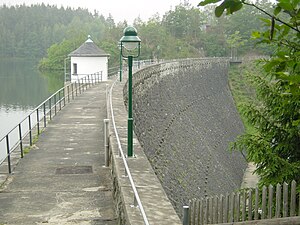
| View of the dam | |||||||||
|
|||||||||
|
|
|||||||||
| Coordinates | 50 ° 42 '20 " N , 11 ° 59' 36" E | ||||||||
| Data on the structure | |||||||||
| Construction time: | 1949-1956 | ||||||||
| Height above valley floor: | 24.5 m | ||||||||
| Height above foundation level : | 32.5 m | ||||||||
| Height of the structure crown: | 318.5 m | ||||||||
| Building volume: | 40 000 m³ | ||||||||
| Crown length: | 166.68 m | ||||||||
| Crown width: | 3.5 m | ||||||||
| Data on the reservoir | |||||||||
| Altitude (at congestion destination ) | 316.35 m | ||||||||
| Water surface | 93 ha | ||||||||
| Storage space | 9.73 million m³ | ||||||||
| Total storage space : | 10.68 million m³ | ||||||||
| Catchment area | 163 km² | ||||||||
| Design flood : | 125 m³ / s | ||||||||
The Weidatalsperre is one of two former drinking water reservoirs on the Weida , near the eastern Thuringian towns of Triebes and Staitz in the Thuringian Slate Mountains .
Reservoir
The dam , which was started in 1949 and put into operation in 1956, holds 9.7 million cubic meters of water. The area of the reservoir is 93 hectares and the maximum storage height is 22.5 m. The reservoir has a length of 4.6 km.
Dam wall
The dam is a gravity dam made of concrete and 32.5 m high. It is slightly curved in plan and clad with broken stones on the air side . A second, smaller dam wall with the flood relief is located on the east side of the reservoir.
use
The dam is used for flood protection and low water elevation.
See also
literature
- Dams in Thuringia. Thuringian dam administration, author college 1993
Picture gallery
Web links
Commons : Weidatalsperre - collection of pictures, videos and audio files


