Kleinwolschendorf
|
Kleinwolschendorf
City of Zeulenroda-Triebes
Coordinates: 50 ° 38 ′ 55 ″ N , 11 ° 56 ′ 55 ″ E
|
||
|---|---|---|
| Height : | 388 m | |
| Residents : | 118 | |
| Incorporation : | April 1, 1992 | |
| Incorporated into: | Zeulenroda | |
| Postal code : | 07937 | |
| Area code : | 036628 | |
|
Location of Kleinwolschendorf in Thuringia |
||
|
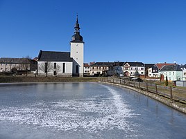
Place with church
|
||
Kleinwolschendorf is a district of the town of Zeulenroda-Triebes in the Greiz district in Thuringia .
location
Kleinwolschendorf is today east of the Zeulenroda dam on the state road 2349, which leads from Zeulenroda into the Schleizer Oberland and to Knau . The district of the village lies on a plateau of the southeast Thuringian slate mountains and extends as far as the outskirts of Zeulenroda .
history
The place originally laid out as a round village was first mentioned in documents in 1414. More recent literature results show May 28, 1399. The church was built in 1728-30 after the previous building was destroyed by fire. From 1920 to 1924 Kleinwolschendorf belonged to the city of Zeulenroda for the first time . With the construction of the Zeulenroda dam, the place lost around 100 hectares of agricultural land as well as the Riedelmühle and the Starkenmühle in the Weidatal . In 1992 Kleinwolschendorf was again incorporated into Zeulenroda after decades of independence. The village had around 120 inhabitants in 2012.
traffic
The nearest train station is Zeulenroda and Bf on the Werdau – Weida – Mehltheuer railway line ; until 1999 the upper station of the Zeulenroda Stadtbahn was the closest train station.
Individual evidence
- ^ Wolfgang Kahl : First mention of Thuringian towns and villages. A manual. Rockstuhl Verlag, Bad Langensalza, 2010, ISBN 978-3-86777-202-0 , p. 148

