
District of Schmölln
| Basic data | |
|---|---|
| District : | Leipzig |
| Administrative headquarters : | Schmoelln |
| Area : | 224 km² |
| Residents: | 31,607 (1989) |
| Population density: | 141 inhabitants per km² |
| License plate : | S and U (1953–1990) SX (1974–1990) SLN (1991–1995) |
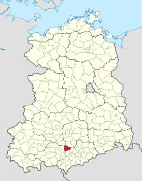
| Location of the district in the GDR | |
  |
|
The Schmölln district was a district in the Leipzig district of the GDR . From 1990 to 1994 it existed as the district of Schmölln in the state of Thuringia . His area is now in the Altenburger Land district in Thuringia. The seat of the district administration was in Schmölln .
geography
location
Filling the triangular southern tip of the Leipzig district, the Schmölln district shared borders with the Halle , Gera and Karl-Marx-Stadt districts . The community of Jonaswalde was the southernmost in the Leipzig district ( Nischwitz district ).
Neighboring areas
The district of Schmölln bordered clockwise in the north, beginning with the districts of Altenburg , Glauchau , Werdau , Gera-Land and Zeitz .
Natural space
The district area reached from the Saxon hill country to the edge heights of the Thuringian slate mountains . Accordingly, the undulating and largely forest-free land surface rose to the south from 220 to 352 m near Nischwitz (highest point). The valleys of the Sprotte and Pleiße divided the plateau with their many small tributaries. Clay soils led over to the central Saxon loess loam area east of the Pleiße. To the south, the loess loam becomes more sandy and stony.
history
The law on the further democratization of the structure and functioning of the state organs in the states in the German Democratic Republic of July 23, 1952 resulted in an extensive district reform in the five remaining states of the GDR . On July 25, 1952, the federal states were dissolved and 14 districts were established. Here traditional circles were dissolved or divided into smaller circles, whereby there were also changes of area beyond the borders of the former 5 countries. The district of Schmölln - split off from the district of Altenburg and expanded by some communities from neighboring districts - was assigned to the district of Leipzig , the city of Schmölln became the district seat .
The following 50 municipalities contributed to the formation of the district in 1952:
- 30 municipalities from the Altenburg district ( Thuringia ):
- Altkirchen , Born grove , Dobitschen , Dobra , drugs , Göldschen , Göllnitz , Gößnitz (city), Großmecka , Großstöbnitz , Köthel , Lumpzig , Mehna , parish village , Podelwitz , Ponitz , Prehna , Röthenitz , Schloßig , Schmölln (city), Taupadel , Thonhausen , Trebula , Untschen , Weißbach , Wildenbörten , Zehma , Zschöpperitz , Zumroda and Zürchau ;
- 16 municipalities from the district of Gera ( Thuringia ):
- Beerwalde , Braunichswalde , Drosen , Gauern , Heukewalde , Jonaswalde , Linda b. Weida , Löbichau , Nischwitz , Nöbdenitz , Paitzdorf , Posterstein , Reichstädt , Rückersdorf , Selka and Vollmershain ;
- Gösau , Grünberg and Heyersdorf from the district of Zwickau ( Saxony ) as well
- Bröckau and Naundorf from the Zeitz district ( Saxony-Anhalt ).
As a result of reclassifications across district boundaries and changes in the municipality, the number of municipalities fell from 49 initially to 22 when the district was dissolved at the end of June 1994:
- December 4, 1952 reclassification from Gauern , Linda b. Weida , Paitzdorf , Reichstädt and Rückersdorf from the Schmölln district to the Gera district
- December 4, 1952 Braunichswalde and Gösau were reclassified from the Schmölln district to the Werdau district
- January 1, 1956 Bröckau is reorganized (excluding the Braunshain district) from the Schmölln district into the Zeitz district
- January 1, 1956 Reclassification of the Braunshain district of the Bröckau community in Lumpzig
- January 1, 1957, Köthel was reclassified from the Schmölln district to the Glauchau district
- January 1, 1957 Reclassification of Naundorf from the Schmölln district to the Altenburg district
- January 1, 1957 Prehna is incorporated in Lumpzig
- January 1, 1957 Göldschen incorporated into Röthenitz
- August 3, 1961 incorporation of Drosen in Löbichau
- August 25, 1961 integration of Röthenitz and Trebula in Altkirchen
- August 25, 1961 Incorporation of Bornshain into Taupadel
- January 1, 1971 incorporation of Dobra (until July 24, 1952 Hartroda) in Wildenbörten
- August 28, 1973 incorporation of Zschöpperitz in Göllnitz
- November 1, 1973 Pfarrsdorf is incorporated into the town of Gößnitz
- November 1, 1973 Großmecka and Zumroda were incorporated in Podelwitz
- 1st November 1973 incorporation of Grünberg in Ponitz
- 1st November 1973 incorporation of Selka in Weißbach
- November 1, 1973 Incorporation of Zürchau into Zehma
- 1st January 1974 incorporation of Beerwalde in Löbichau
- 1st January 1974 incorporation of Untschen in Nöbdenitz
- January 1st, 1974 Schloßig is incorporated into the town of Schmölln
- 1st April 1974 incorporation of Nischwitz in Jonaswalde
- March 8, 1994 Integration of Weißbach into the town of Schmölln

On May 17, 1990, the district was renamed the Schmölln district. For reunification of the circle was the ländereinführungsgesetz the re-established country Thuringia awarded. During the Thuringian district reform on July 1, 1994, it was incorporated into the Altenburger Land district.
politics
District Administrator
The only district administrator in the district was the CDU politician Burghardt Böttcher, from 1990 to 1994.
Culture and sights
- Ernst-Agnes-Turm Schmölln - landmark of the city
- Downtown Schmölln with church, town hall and city wall
- Renaissance Ponitz Castle
- Ponitz church with Silbermann organ (1734–1737)
- 1000 year old oak Nöbdenitz
- Dobitschen moated castle from the baroque era
- Posterstein Castle
- Park and Castle Tannenfeld
- Löbichau Castle
- Lumpzig post mill
- Half-timbered house Gieba
- Altkirchen Village Museum (with local history room)
Economy and Transport
The importance of agriculture in the district was underlined by corresponding businesses in the district town ( grain drying plant , dairy cattle plant for 2000 cattle, agrochemical center , district operation for agricultural technology ). Schmölln and Gößnitz were also locations for a diverse industry (mechanical engineering, precision tools, buttons, shoes, brushes, wooden goods, pharmaceuticals, pumps, woven goods, toys). Industrialization was promoted by the construction of the railway from 1844. Schmölln is on the main railway line Leipzig-Altenburg-Gera and on the F7 from Altenburg to Gera. The F 93 passed through Gößnitz in the east of the district . In 1865 the city became the railway junction of the Leipzig-Hof line with the routes to Chemnitz and Gera . In the south of the district there was a connection to the Autobahn 4 at the Ronneburg exit , the Schmölln junction was only released in 1993.
Population data of cities and municipalities
Population overview of all 23 communities in the district that came to the re-established state of Thuringia in 1990.
| TGS | AGS | local community | Residents | Area (ha) | |
| 10/03/1990 | December 31, 1990 | ||||
| 131001 | 16037010 | Altkirchen | 1,350 | 1,337 | 2.005 |
| 131003 | 16037030 | Dobitschen | 698 | 699 | 655 |
| 131005 | 16037050 | Drugs | 170 | 165 | 426 |
| 131006 | 16037060 | Göllnitz | 378 | 374 | 506 |
| 131007 | 16037070 | Gößnitz, city | 5,144 | 5.107 | 1,404 |
| 131009 | 16037090 | Großstöbnitz | 870 | 861 | 646 |
| 131011 | 16037110 | Heukewalde | 218 | 216 | 589 |
| 131012 | 16037120 | Heyersdorf | 179 | 181 | 378 |
| 131013 | 16037130 | Jonaswalde | 365 | 362 | 666 |
| 131014 | 16037140 | Löbichau | 1,268 | 1,261 | 1,673 |
| 131015 | 16037150 | Sloppy | 719 | 713 | 1,074 |
| 131016 | 16037160 | Mehna | 422 | 419 | 469 |
| 131018 | 16037180 | Nöbdenitz | 1,218 | 1,200 | 1,001 |
| 131020 | 16037200 | Podelwitz | 798 | 794 | 1,457 |
| 131021 | 16037210 | Ponitz | 1,984 | 1,978 | 1,704 |
| 131022 | 16037220 | Poster stone | 370 | 369 | 553 |
| 131024 | 16037240 | Schmölln, city | 12,045 | 12,098 | 2,598 |
| 131026 | 16037260 | Taupadel | 390 | 387 | 695 |
| 131027 | 16037270 | Thonhausen | 683 | 681 | 943 |
| 131029 | 16037290 | Vollmershain | 307 | 304 | 500 |
| 131030 | 16037300 | Weissbach | 688 | 688 | 903 |
| 131031 | 16037310 | Wildenbörten | 413 | 414 | 781 |
| 131032 | 16037320 | Zehma | 633 | 631 | 771 |
| 1310 | 16037 | Country circular Schmölln | 31,310 | 31,239 | 22,397 |
License Plate
Motor vehicles (with the exception of motorcycles) and trailers were assigned three-letter distinguishing signs starting with the pair of letters SX from around 1974 to the end of 1990 . The last number plate series used for motorcycles was SY 60-01 to SY 80-00 .
At the beginning of 1991 the district received the distinctive sign SLN . It was issued until January 31, 1995. It has been available in the Altenburger Land district since November 29, 2012 .
Individual evidence
- ^ Thuringian State Office for Environment and Geology
- ↑ a b various (ed.): Diercke Lexicon Germany - German Democratic Republic and Berlin (East), p. 242 . Georg Westermann Verlag GmbH, Braunschweig 1986, ISBN 3-07-508861-7 .
- ↑ Law on the further democratization of the structure and functioning of the state organs in the states in the GDR of July 23, 1952. Online at www.verfassungen.de.
- ↑ Selka on gov.genealogy.net
- ↑ Law on the self-administration of municipalities and districts in the GDR (municipal constitution) of May 17, 1990
- ↑ Federal Statistical Office (Ed.): Municipalities 1994 and their changes since 01.01.1948 in the new federal states . Metzler-Poeschel, Stuttgart 1995, ISBN 3-8246-0321-7 .
- ^ Thuringian State Office for Statistics - information service
- ↑ Andreas Herzfeld: The history of the German license plate . 4th edition. German Flag Society V., Berlin 2010, ISBN 978-3-935131-11-7 , pp. 303 .
- ↑ Andreas Herzfeld: The history of the German license plate . 4th edition. German Flag Society V., Berlin 2010, ISBN 978-3-935131-11-7 , pp. 528 .
1922–1952: Altenburg | Altenburg (city) | Apolda (city) | Arnstadt | Arnstadt (city) | District Department Camburg | Eisenach | Eisenach (city) | Erfurt | Erfurt (city) | Gera | Gera (city) | Gotha | Gotha (city) | Greiz | Greiz (city) | Heiligenstadt | Hildburghausen | County of Hohenstein | Ilfeld | Jena | Jena (city) | Langensalza | Meiningen | Mulhouse | Mühlhausen (city) | Nordhausen (city) | Rudolstadt | Saalfeld | Schleiz | Schleusingen | Reign of Schmalkalden | Sondershausen | Sonneberg | Stadtroda | Weimar | Weimar (city) | Weissensee | Worbis | Zella-Mehlis (city) | Ziegenrück . 1952–1994: Altenburg | Apolda | Arnstadt | Artern | Bad Salzungen | Eisenach | Eisenberg | Erfurt-Land | Erfurt (city) | Gera-Land | Gera (city) | Gotha | Greiz | Heiligenstadt | Hildburghausen | Ilmenau | Jena-Land | Jena (city) | Langensalza | Lobenstein | Meiningen | Mulhouse | Neuhaus / Rwg. | Nordhausen | Pößneck | Rudolstadt | Saalfeld | Schleiz | Schmalkalden | Schmölln | Sömmerda | Sondershausen | Sonneberg | Stadtroda | Suhl-Land | Suhl (city) | Weimar-Land | Weimar (city) | Worbis | Zeulenroda .