
Chub district
Coordinates: 51 ° 7 ' N , 13 ° 7' E
| Basic data (as of 1990) | |
|---|---|
| Existing period: | 1952-1990 |
| District : | Leipzig |
| Administrative headquarters : | Chub |
| Area : | 421.53 km² |
| Residents: | 89,858 (Dec. 31, 1989) |
| Population density: | 213 inhabitants per km² |
| License plate : | S, U (1953–1990) SF, SG (1974–1990) |
| Circle structure: | 86 |
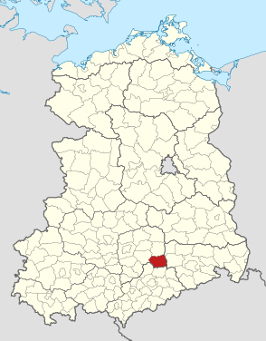
| Location of the district in the GDR | |
  |
|
The Döbeln district was a district in the Leipzig district of the GDR . From 1990 it existed as the district of Döbeln in the Free State of Saxony . His area is now in the Central Saxony district . The seat of the district administration was in Döbeln .
geography
location
The Döbeln district was in the extreme southeast corner of the Leipzig district.
Neighboring areas
The district of Döbeln bordered clockwise in the north, beginning with the districts of Oschatz , Riesa , Meißen , Hainichen , Rochlitz and Grimma .
Natural space
The district lay on both sides of the lower Freiberg Mulde in the loess area of the Central Saxon mountainous region . The northern part belonged to the core area of the Lommatzscher care . This loess plateau, which is strongly structured by valleys and hills, rose slightly towards the south at an average altitude of 200 m. An extensive network of streams, the abundance of sources of which was due to the water-holding power of loess, covered the mountainous region. With favorable climatic conditions, arable farming with high productivity was possible on the deep loess loam soils . South of a line Döbeln-Leisnig joined the Central Saxon loess loam area. The plate was covered with a layer of loess, the thickness of which gradually decreased towards the south. Therefore, in the south of the district - also in connection with the increasing rainfall - the yields in arable farming were lower. Between Roßwein and Waldheim, the plateau rose to a height of 296 m. The deepest point in the district was reached in the valley of the Freiberger Mulde below Leisnig with a height of 142 m. This shows how deeply the two main rivers Freiberger Mulde and Zschopau are cut into the mountainous region. The loess slabs were free of forests; mixed deciduous and mixed forests only grew on the valley slopes. In the valley of the Zschopau and the depression that was to Leisnig conservation area Freiberger Mulde - Lower Zschopau reported. There were also seven nature reserves; the largest in area were Scheergrund and Schafbachtal, Hochweitzschener Wald and Kirstenmühle.
history
1874 Saxony were part of a comprehensive administrative reform in the Kingdom of new district governor teams and Amtshauptmann teams established. As a district-free city , Döbeln resigned from the office on April 1, 1924. At the beginning of 1939, the administrative authority was renamed the Döbeln district. In 1946 the urban district was reintegrated into the Döbeln district. At the census on October 29, 1946, the city district no longer existed.
Circle formation 1952
The district of Döbeln belonged to the state of Saxony after 1945 and thus to the GDR since 1949. The law on the further democratization of the structure and functioning of the state organs in the states of the German Democratic Republic of July 23, 1952 resulted in an extensive district reform in the GDR and the five remaining states . On July 25, 1952, the federal states were dissolved and 14 districts were established. Here traditional circles were dissolved or divided into smaller circles, whereby there were also changes of area beyond the borders of the former 5 countries. The Döbeln district was assigned to the Leipzig district , the city of Döbeln became the seat of the district .
The district of Döbeln gave up 35 of its 107 municipalities, as follows:
- 6 municipalities in the Grimma district :
- Böhlen, Dürrweitzschen b. Leisnig, Kuckeland, Leipnitz, Motterwitz and Zschoppach;
- 26 municipalities in the county Hainichen , district Karl-Marx-Stadt :
- Arnsdorf, Beerwalde, Berbersdorf, Böhrigen, Cunnersdorf, Dittersdorf, Ehrenberg, Etzdorf, Falkenau, Gersdorf, Goßberg, Greifendorf, Grunau, Grünlichtenberg, Hainichen, Höckendorf bei Waldheim, Höfchen, Kaltofen, Kriebethal, Marbach, Mobendorf, Moosheim, Naundorf bei Roßwein, Pappendorf, Reichenbach and Schlegel;
- 3 communities in the county Rochlitz , district Karl-Marx-Stadt :
- Holzhausen, Langenau and Seelitz.
In return, he received parishes from the following districts:
- 1 municipality from the Grimma district :
- Bockwitz
- 11 municipalities from the Oschatz district :
- Auerschütz, Börtewitz, Gallschütz, Jahna, Kiebitz, (Neusornzig), Pulsitz, Schrebitz, Strocken and (Gävertitz);
- as well as the community of Choren from the Meissen district .
Together with the 72 communities remaining in the old district of Döbeln :
- Altendorf, Brösen, Bockelwitz, Döbeln, thirty, Dürrweitzschen b. Döbeln, Ebersbach, Fischendorf, Gadewitz, Gebersbach, Gersdorf b. Esinig, Gleisberg, Gorschmitz, Goselitz, Großsteinbach, Großweitzschen, Hartha, Haßlau, Heiligenborn, Höckendorf b. Döbeln, Kieselbach, Klosterbuch, Knobelsdorf, Kroptewitz, Leisnig, Limmritz, Littdorf, Mannsdorf, Massanai, Meinitz, Mainsberg, Minkwitz, Mochau, Mockritz, Naundorf b. Leisnig, Naunhof, Niederstriegis, Noschkowitz, Oberranschütz, Ostrau b. Döbeln, Ottewig, Otzdorf, Polditz, Polkenberg, Reinsdorf, Rittmitz, Röda, Roßwein, Rudelsdorf, Schönberg, Schönerstadt b. Leisnig, Seifersdorf b. Leisnig, Seifersdorf b. Roßwein, Simselwitz, Sitten, Steina, Stockhausen, Technitz, Theeschütz, Töpeln, Tragnitz, Tronitz, Waldheim, Wallbach, Wendishain, Westewitz, Zaschwitz, Ziegra, Zollschwitz, Zschaitz, Zschepplitz and Zschockau
This is how the Döbeln district (with 86 communities) was created in a new structure.
Changes in municipal area from 1952 to 1990
As a result of changes in municipal area and reclassifications across district borders , the number of municipalities decreased to 52 by May 17, 1990.
- December 4, 1952 Reclassification of Beicha, Lüttewitz and Zschochau from the Meißen district to the Döbeln district
- December 4, 1952 Reclassification of Grunau from the Hainichen district to the Döbeln district
- January 1, 1954 Bockwitz is reclassified from the Döbeln district to the Grimma district
- January 1, 1960 incorporation of Theeschütz in Lüttewitz
- January 1, 1960 Tragnitz is incorporated into the city of Leisnig
- January 1, 1960 Tronitz is incorporated into Mockritz
- September 15, 1961 Jahna and Pulsitz merge to form Jahna-Pulsitz
- September 15, 1961 incorporation of Rudelsdorf into Gebersbach
- January 1st, 1962 Ottewig is incorporated in Dürrweitzschen
- January 1, 1962 Stockhausen incorporated into Limmritz
- December 28, 1962 incorporation of Kroptewitz in Bockelwitz
- July 1, 1963 Integration of Altenhof, Naundorf and Zollschwitz into Naunhof
- October 10, 1965 Incorporation of thirty in Lüttewitz
- October 10, 1965 Fischendorf, Klosterbuch and Meinitz are incorporated into the town of Leisnig
- October 10, 1965 Incorporation of Röda in Gorschmitz
- October 10, 1965 Zschockau is incorporated into Polkenberg
- January 1st, 1967 incorporation of Höckendorf in Großweitzschen
- January 1st, 1968 Incorporation of Mischütz in Zschaitz
- January 1, 1968 incorporation of Seifersdorf b. Leisnig in Schönerstädt
- January 1st, 1968 incorporation of Simselwitz in Mochau
- January 1st, 1968 incorporation of Strocken into Gallschütz
- April 1, 1968 Schoenberg is incorporated into the city of Waldheim
- 1st April 1968 incorporation of Zschochau into Ostrau
- January 1, 1969 Incorporation of Brösen and Gorschmitz into the city of Leisnig
- January 1, 1969 Goselitz incorporated into Zschaitz
- 1st January 1969 incorporation of Großsteinbach in Mochau
- January 1st 1969 incorporation of Kieselbach in Gersdorf
- January 1, 1969 incorporation of Seifersdorf b. Roßwein to the city of Roßwein
- January 1, 1969 Wallbach is incorporated into the city of Hartha
- January 1, 1970 Gebersbach and Knobelsdorf merge to form Gebersbach-Knobelsdorf
- January 1st, 1970 Integration of Otzdorf into Littdorf
- January 1, 1972 incorporation of Mannsdorf into Ebersbach
- January 1, 1972 Zaschwitz is incorporated into Großweitzschen
- January 1, 1973 Limmritz and Meinsberg are incorporated into Ziegra
- January 1, 1973 Incorporation of Rittmitz into Noschkowitz
- January 1, 1973 incorporation of Zschepplitz into Mockritz
- June 1, 1973 incorporation of Grunau in Niederstriegis
- June 1, 1973 Polditz incorporated into Polkenberg
- June 1, 1973 incorporation of Sion into Bockelwitz
- August 24, 1973 integration of Heiligenborn into the city of Waldheim
- January 1, 1974 Gadewitz incorporated into Mockritz
- January 1st, 1974 Gertitzsch is outsourced from Theeschütz and incorporated into Choren
- January 1, 1974 Incorporation of Massanei into the city of Waldheim
- January 1st, 1974 Oberranschütz is incorporated into the town of Döbeln
- January 1st 1974 incorporation of Wetterwitz into Gleisberg
- January 1, 1978 incorporation of Schönerstädt in Gersdorf
On May 17, 1990, the district was renamed the Döbeln district . On the occasion of the reunification of the circle was the ländereinführungsgesetz the re-established land Saxony awarded. The external structure was retained until the first district reform in Saxony, which came into force on August 1, 1994. The district of Döbeln was the only district to survive this reform unchanged in the same structure and was only combined with the districts of Freiberg and Mittweida to form the district of central Saxony in August 2008 .
Economy and Transport
In the towns of the Döbeln district, many medium-sized and small businesses in the textile, consumer goods, food and luxury goods industries, mechanical engineering and the electrical industry determined the industrial structure. The VEB Döbelner fittings and metal work and the VEB Kombinat meat "Spicy" were important production facilities in the district town. Other VEBs were an electric motor factory for micro and micro motors as well as the United House Shoe Works in Hartha, the forge "Hermann Matern" in Roßwein and the cosmetics factory "Florena" in Waldheim. In agricultural production, sugar beet and fodder crops were grown in the north-eastern part of the district and wheat and fodder crops were grown in the western part of the district. Hops were grown in the area around Döbeln. There were extensive fruit and berry crops near Waldheim and Leisnig. The largest operation was the LPG fruit production Dürrweitzschen. Several LPGs (T) ran cattle in large stables.
Döbeln was conveniently located at the intersection of the main railway lines Berlin-Riesa-Karl-Marx-Stadt, construction of which began in 1847, with the line from Leipzig via Meißen to Dresden (1868) in the Muldental. The connection to the railway network promoted industrialization, especially in metal production. In addition, the main roads from Karl-Marx-Stadt to Riesa ( F 169 ) and from Gera to Freiberg ( F 175 ) crossed in the district town . Immediately north of Döbeln the motorway from Leipzig to Dresden ( A 14 ) crossed the district with the two connections Döbeln-Nord and Döbeln-Süd.
politics
District Administrator
Until 1990 this function corresponded to the chairman of the council of the district .
- 1954–1961 Friedrich Schaarschmidt (1900–1985)
Population data of cities and municipalities
Population overview of all 39 municipalities in the district that came to the re-established state of Saxony in 1990.
| TGS | AGS | local community | Residents | Area (ha) | |
| 10/03/1990 | December 31, 1990 | ||||
| 130401 | 14021010 | Auerschütz | 301 | 294 | 729 |
| 130402 | 14021020 | Beicha | 394 | 394 | 722 |
| 130403 | 14021030 | Bockelwitz | 764 | 763 | 1,507 |
| 130404 | 14021040 | Börtewitz | 397 | 391 | 565 |
| 130406 | 14021060 | Choirs | 406 | 403 | 443 |
| 130407 | 14021070 | Chub, city | 27,112 | 26,827 | 2,850 |
| 130408 | 14021080 | Dürrweitzschen | 436 | 441 | 907 |
| 130409 | 14021090 | Ebersbach | 1,015 | 990 | 675 |
| 130411 | 14021110 | Gallschütz | 505 | 501 | 981 |
| 130412 | 14021120 | Gebersbach-Knobelsdorf | 737 | 740 | 1,281 |
| 130413 | 14021130 | Gersdorf | 1,058 | 1,067 | 1,479 |
| 130414 | 14021140 | Gleisberg | 837 | 836 | 893 |
| 130418 | 14021180 | Großweitzschen | 1.105 | 1,096 | 1,368 |
| 130420 | 14021200 | Hartha, city | 8,405 | 8,282 | 1,559 |
| 130421 | 14021210 | Hasslau | 634 | 640 | 1,028 |
| 130423 | 14021230 | Jahna-Pulsitz | 657 | 646 | 1,205 |
| 130424 | 14021240 | lapwing | 499 | 495 | 582 |
| 130427 | 14021270 | Leisnig, city | 8,378 | 8,324 | 2,576 |
| 130429 | 14021290 | Littdorf | 421 | 420 | 716 |
| 130430 | 14021300 | Lüttewitz-thirty | 875 | 865 | 1.311 |
| 130434 | 14021340 | Minkwitz | 348 | 345 | 420 |
| 130435 | 14021350 | Mochau | 1,185 | 1,174 | 1.405 |
| 130436 | 14021360 | Mockritz | 1,264 | 1,254 | 1,861 |
| 130437 | 14021370 | Naunhof | 744 | 724 | 1,382 |
| 130438 | 14021380 | Niederstriegis | 892 | 890 | 757 |
| 130439 | 14021390 | Noschkowitz | 466 | 464 | 778 |
| 130441 | 14021410 | Ostrau | 2,368 | 2,352 | 1,247 |
| 130444 | 14021440 | Polkenberg | 1,155 | 1,150 | 1,308 |
| 130445 | 14021450 | Reinsdorf | 462 | 456 | 747 |
| 130447 | 14021470 | Roßwein, city | 7,740 | 7,686 | 992 |
| 130450 | 14021500 | Schrebitz | 653 | 655 | 719 |
| 130453 | 14021530 | Steina | 399 | 394 | 804 |
| 130454 | 14021540 | Technitz | 570 | 554 | 407 |
| 130455 | 14021550 | Pottery | 284 | 290 | 367 |
| 130456 | 14021560 | Waldheim, city | 9,642 | 9,609 | 1,634 |
| 130458 | 14021580 | Wendishain | 670 | 663 | 1,354 |
| 130459 | 14021590 | Westewitz | 1,412 | 1,417 | 239 |
| 130462 | 14021620 | Ziegra | 1.313 | 1.306 | 1,441 |
| 130463 | 14021630 | Zschaitz | 1,042 | 1,036 | 915 |
| 1304 | 14021 | Country circular Döbeln | 87,545 | 86,834 | 42,154 |
License Plate
Motor vehicles (with the exception of motorcycles) and trailers were assigned three-letter distinguishing signs starting with the letter pairs SF and SG from around 1974 to the end of 1990 . The last number plate series used for motorcycles was UA 00-01 to UA 50-00 .
At the beginning of 1991 the district received the distinguishing mark DL .
Individual evidence
- ↑ Law on the further democratization of the structure and functioning of the state organs in the states in the GDR of July 23, 1952. Online at www.verfassungen.de.
- ↑ a b Federal Statistical Office (ed.): Municipalities 1994 and their changes since 01.01.1948 in the new federal states . Metzler-Poeschel, Stuttgart 1995, ISBN 3-8246-0321-7 .
- ↑ Law on the self-administration of municipalities and districts in the GDR (municipal constitution) of May 17, 1990
- ↑ StBA Area: changes from 01.01. until December 31, 2008
- ↑ various (ed.): Diercke Lexicon Germany - German Democratic Republic and Berlin (East), p. 77 . Georg Westermann Verlag GmbH, Braunschweig 1986, ISBN 3-07-508861-7 .
- ↑ Saxony regional register
- ↑ Andreas Herzfeld: The history of the German license plate . 4th edition. German Flag Society V., Berlin 2010, ISBN 978-3-935131-11-7 , pp. 302 .
- ↑ Andreas Herzfeld: The history of the German license plate . 4th edition. German Flag Society V., Berlin 2010, ISBN 978-3-935131-11-7 , pp. 528 .