Ziegra-Knobelsdorf
|
Former municipality of
Coordinates: 51 ° 6 ′ 13 ″ N , 13 ° 3 ′ 25 ″ E
Ziegra-Knobelsdorf |
|
|---|---|
| Height : | 264 m |
| Area : | 31.03 km² |
| Residents : | 2143 (Dec. 31, 2011) |
| Population density : | 69 inhabitants / km² |
| Incorporation : | January 1, 2013 |
| Incorporated into: | Chub and Waldheim |
| Postcodes : | 04720, 04736 |
| Primaries : | 03431, 034327 |
|
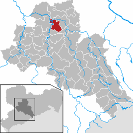
Location of the former municipality of Ziegra-Knobelsdorf in the district of central Saxony
|
|
Ziegra-Knobelsdorf was a municipality in the district of Central Saxony , Free State of Saxony . It belonged to the Waldheim administrative community . The seat of the municipal administration was in the district of Ziegra. The community was formed on January 1, 1994 through the merger of the then independent communities Gebersbach-Knobelsdorf and Ziegra. On January 1, 2013, it was dissolved and divided between the neighboring towns of Döbeln and Waldheim .
geography
The community was about 5 km southwest of the town of Döbeln and 5 km north of Waldheim above the Zschopau valley . The districts of Wöllsdorf and Töpeln were directly in the Zschopau valley. Half of the municipality was in the Zschopautal landscape protection area .
Local division
Districts were
- Forchheim, Kleinlimmritz, Limmritz, Pischwitz, Schweta, Stockhausen, Töpeln, Wöllsdorf and Ziegra (1033 inhabitants on December 31, 2011 on 1327 ha), which are now part of Döbeln
- the places Gebersbach, Heyda, Kaiserburg, Knobelsdorf, Meinsberg , Neuhausen and Rudelsdorf (1110 inhabitants on December 31, 2011 on 1778 ha), which are now part of Waldheim .
There are the following districts in the former municipality :
|
|
Kleinlimmritz and Schweta are in the Limmritz district.
history
Incorporations
All incorporations are listed here that took place before the new formation of the community Ziegra-Knobelsdorf in the later area of this community.
| Former parish | date | annotation |
|---|---|---|
| Forchheim | July 1, 1950 | Incorporation to Ziegra |
| Gebersbach | January 1, 1970 | Merger with Knobelsdorf to Gebersbach-Knobelsdorf |
| Gebersbach-Knobelsdorf | January 1, 1994 | Merger with Ziegra to Ziegra-Knobelsdorf |
| Heyda | July 1, 1950 | Incorporation to Knobelsdorf |
| Kleinlimmritz | before 1880 | Incorporation to Limmritz |
| Knobelsdorf | January 1, 1970 | Merger with Gebersbach to Gebersbach-Knobelsdorf |
| Limmritz (Großlimmritz) | 1st January 1973 | Incorporation to Ziegra |
| Meinsberg | 1st January 1973 | Incorporation to Ziegra |
| Neuhausen | July 1, 1950 | Incorporation to Meinsberg |
| Pischwitz | before 1880 | Incorporation after Töpeln |
| Rudelsdorf | Sept 15, 1961 | Incorporation to Gebersbach |
| Schweta | before 1923 | Incorporation to Limmritz |
| Stockhausen | January 1, 1962 | Incorporation to Limmritz |
| Pottery | January 1, 1991 | Incorporation to Ziegra |
| Wöllsdorf | April 1, 1921 | Incorporation after Töpeln |
| Ziegra | January 1, 1994 | Merger with Gebersbach-Knobelsdorf to Ziegra-Knobelsdorf |
Culture and sights
- Zschopautal
- town hall
- Gebersbach outdoor pool
- Limmritz local recreation area
- Stockhausen Castle
- Stockhausen mill
- Slavic hill fort (Burgward) so-called Schwedenschanze in Ziegra
- Schweta Castle (the foundation walls still preserved)
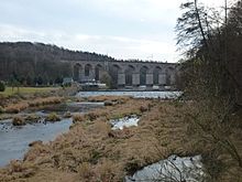
- Viadukt Limmritz ( bankruptcy mile of the Riesa – Chemnitz railway line )
Economy and Infrastructure
traffic
The B 175 runs through the north of the former municipal area, the town of Töpeln, and the B 169 to the east through Heyda . The former municipality can also be reached via the A 14 connections Döbeln-Nord or Döbeln-Ost (around 10 kilometers) or the A 4 connection in Hainichen (around 20 kilometers). Limmritz lies on the Riesa – Chemnitz railway line and is served by regional trains that run every hour from Elsterwerda and Chemnitz .
education
The Kurt Schwabe Institute is located in Meinsberg .
Personalities who come from here
- Jonathan August Weichert (1788–1844), German classical philologist and pedagogue, rector of the Princely School Grimma for 20 years
Web links
- Ziegra-Knobelsdorf in the Digital Historical Directory of Saxony
- Ziegra in the Digital Historical Directory of Saxony
- Knobelsdorf in the Digital Historical Directory of Saxony
Individual evidence
- ↑ StBA: Changes in the municipalities in Germany, see 1994 and 2013
- ↑ Stat. LA Saxony - Area changes 2013 (PDF; 13 kB)
- ↑ Saxony Atlas
- ↑ a b c d e f g h i Federal Statistical Office (ed.): Municipalities 1994 and their changes since 01.01.1948 in the new federal states . Metzler-Poeschel, Stuttgart 1995, ISBN 3-8246-0321-7 .
- ↑ a b c lists of the municipalities incorporated since May 1945 and evidence of the breakdown of the independent manor districts and state forest districts, 1952, publisher: Ministry of the Interior of Saxony
- ↑ a b c State Statistical Office of the Free State of Saxony: Area changes
- ↑ a b c The Saxony Book, Kommunal-Verlag Sachsen KG, Dresden, 1943


